

Our North America Mountains Map helps you explore the continent’s major mountain ranges, highest peaks, and physical geography with a high-quality printable map. Whether you are a student, teacher, traveler, researcher, or geography enthusiast, this map provides an easy way to identify the most important mountain systems across North America.
North America covers approximately 24.7 million square kilometers (9.54 million square miles), making it the third-largest continent in the world. It includes Canada, the United States, Mexico, Greenland, and the countries of Central America and the Caribbean. The continent is known for its diverse landscapes, from towering mountain ranges and volcanic peaks to vast plains and deserts.
Our printable North America Mountains Map is designed for educational purposes, classroom learning, geography projects, travel planning, and reference.
- World coronavirus map
- World geographical map
- World map for kids
- World Map Wallpaper
- World population map
- Accurate map of World
- Ancient World map
Map of North America Mountains

A Map of North America Mountains highlights the major mountain ranges that stretch across the western, eastern, and northern parts of the continent. Most of the highest mountains are located in the western region due to tectonic plate activity along the Pacific Ring of Fire.
Some of the most significant mountain ranges include:
- Rocky Mountains
- Alaska Range
- Cascade Range
- Sierra Nevada
- Coast Mountains
- Brooks Range
- Appalachian Mountains
- Sierra Madre Occidental
- Sierra Madre Oriental
- Trans-Mexican Volcanic Belt
These mountain systems influence the continent’s climate, rivers, wildlife, forests, and ecosystems.
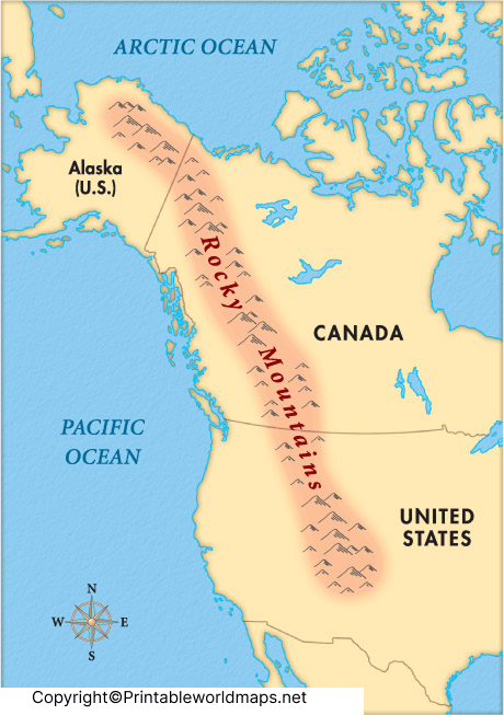
Map of North America Rocky Mountains

The North America Rocky Mountains Map focuses on one of the world’s longest mountain systems.
The Rocky Mountains extend for approximately 4,800 km (3,000 miles) from British Columbia and Alberta in Canada through the western United States to New Mexico.
Some of the famous peaks include:
- Mount Elbert (USA) – 4,401 m
- Longs Peak (USA) – 4,346 m
- Mount Robson (Canada) – 3,954 m
The Rocky Mountains are famous for:
- National Parks
- Ski Resorts
- Wildlife Habitats
- Hiking Trails
- Alpine Lakes
- Glacier Landscapes
They also form the Continental Divide, separating rivers flowing toward the Pacific Ocean from those flowing toward the Atlantic Ocean.
Printable North America Mountains Map
Our printable North America Mountains Map is available in high-resolution format and can be used for:
- School Geography Projects
- Classroom Teaching
- Competitive Exam Preparation
- Physical Geography Studies
- Travel Planning
- Wall Maps
- Homeschool Learning
The printable version makes it easy to label mountain ranges, rivers, neighboring countries, and important physical features.
North America Mountains Map
Well, the physical map is the best tool to explore all the mountains in North America. The continent is home to the number of high peak mountains of the world just like the other continents. The majority of North American mountains are located in the Westernmost region of the continent. For instance, rocky mountains, Sierra Nevada, cascade range, Alaska range are some of the prominent names of mountains in the region.

There are however the tons of mountains in the North America region for the explores. This is where the map of North American mountains can exactly help out the users. In this map, readers can explore the whole extensive view of North American mountains whether it’s in the region of Canada or the USA, etc.
Map of North America Mountains Physical
A Map of North America Mountains Physical displays mountains along with other natural landforms such as:
- Plateaus
- Rivers
- Lakes
- Valleys
- Plains
- Deserts
- Forests
- Coastlines
The western mountain systems were primarily formed by the collision of tectonic plates over millions of years. The eastern Appalachian Mountains, by contrast, are among the oldest mountain ranges on Earth and have experienced significant erosion over time.
This physical map helps users understand how mountain ranges shape weather patterns, biodiversity, and water systems throughout North America.

So, it will subsequently save your efforts so that you can freely explore the mountains of North America. If you like our printable North America mountains map templates then kindly share them with others as well.
Highest Mountains in North America
| Mountain | Height | Country |
|---|---|---|
| Denali | 6,190 m (20,310 ft) | United States (Alaska) |
| Mount Logan | 5,959 m (19,551 ft) | Canada |
| Pico de Orizaba | 5,636 m (18,491 ft) | Mexico |
| Mount Saint Elias | 5,489 m (18,008 ft) | USA/Canada |
| Popocatépetl | 5,426 m (17,802 ft) | Mexico |
Interesting Facts About North America’s Mountains
- The Rocky Mountains stretch across two countries—Canada and the United States.
- Denali is the highest mountain in North America.
- The Appalachian Mountains are more than 480 million years old, making them among the oldest mountain ranges on Earth.
- The Cascade Range contains several active volcanoes, including Mount St. Helens, Mount Rainier, and Mount Hood.
- The Sierra Nevada contains Mount Whitney, the highest peak in the contiguous United States.
- North America’s mountains are home to wildlife such as grizzly bears, mountain goats, bighorn sheep, wolves, and bald eagles.
Why Use Our North America Mountains Map?
Our maps are designed to provide accurate geographic information for educational and reference purposes.
Benefits include:
- High-resolution printable maps
- Easy-to-read mountain labels
- Suitable for students and teachers
- Ideal for research and assignments
- Useful for geography quizzes
- Free download and printing
- Updated using reliable geographic references
Conclusion
Our North America Mountains Map is an excellent educational resource for exploring the continent’s major mountain ranges and physical geography. Whether you’re studying the Rocky Mountains, Alaska Range, Appalachian Mountains, Sierra Nevada, or Mexico’s volcanic ranges, this printable map offers a clear and accurate overview for learning, research, and travel planning.
Reference Links
- U.S. Geological Survey (USGS): https://www.usgs.gov
- National Geographic: https://www.nationalgeographic.com
- Encyclopaedia Britannica – North America: https://www.britannica.com/place/North-America
- NASA Earth Observatory: https://earthobservatory.nasa.gov
