

Explore the Ptolemy World Map with printable map images and PDF downloads inspired by the geographical work of Claudius Ptolemy, a Greco-Roman scholar who lived during the second century CE. His influential work, Geography, organized information about thousands of places using geographical coordinates and explained mathematical methods for representing the known world on a map.
This page brings together several printable versions of the Ptolemaic world map for students, teachers, history enthusiasts, and anyone interested in the evolution of cartography. You can view the maps online, download the available PDFs, and use them for historical study, classroom activities, or personal reference.
Historical note: Ptolemy lived approximately 100–170 CE, but the surviving maps associated with his Geography come from later manuscript and printing traditions. The date 1407 in this page’s title should not be taken as the date of an original map drawn by Ptolemy. The exact date and provenance of each displayed image should be verified against its original source where possible.
Ptolemy World Map Printable
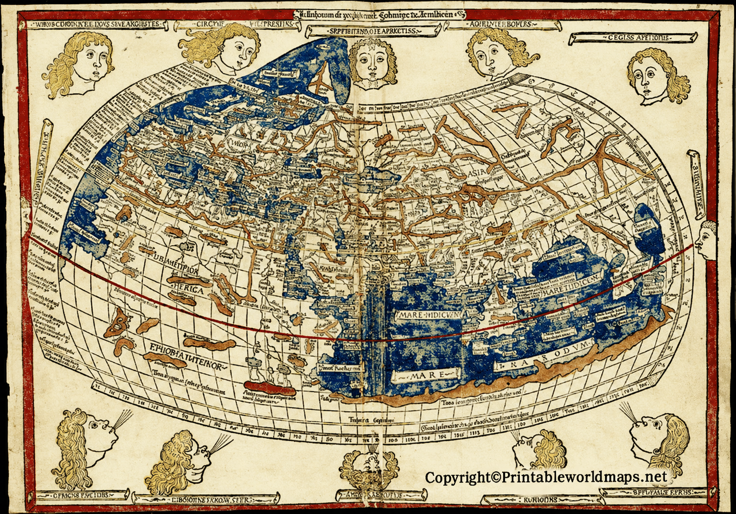
The printable Ptolemy world map provides a visual introduction to the geographical ideas preserved in Ptolemy’s Geography. The work described the inhabited world known to Greco-Roman scholars and provided coordinates that could be used to construct maps.
Use the map as a historical learning resource rather than a modern navigation map. Ancient geographical knowledge was incomplete, and the positions, distances, coastlines, and proportions shown in historical reconstructions may differ considerably from present-day maps.
The PDF version is useful for classroom discussions, geography assignments, historical comparisons, and map-based learning activities. Before printing, check the document’s page size and print settings to ensure that labels and fine details remain legible.
Ptolemy World Map 1407

The Ptolemy world map associated with the year 1407 offers an opportunity to explore the transmission of ancient geographical knowledge through medieval and early Renaissance Europe. Ptolemy’s work became particularly influential when scholars translated and circulated it, and later mapmakers used its geographical data to prepare new maps.
The year 1407 should be understood as a date associated with this particular map version or its presentation, not as the date of Ptolemy’s original work. The historical date of a specific image depends on the manuscript, edition, or reproduction from which it was taken.

Ptolemaic maps are especially interesting because they connect written geographical records with the practical task of representing the world on a flat surface. They also reveal how historical mapmakers interpreted the information available to them.
Different versions of Ptolemaic maps may vary in their layout, lettering, projection, and geographical details. Such differences can reflect the choices of later copyists, translators, engravers, and editors rather than changes made by Ptolemy himself.
When studying these images, compare the overall outline of the known world, the arrangement of regions, the geographical grid, and the labels. These features help explain how cartography developed from the preservation and reinterpretation of earlier geographical knowledge.
Ptolemy Map of World
The Ptolemy map of the world is a useful resource for understanding historical geography. Ptolemy’s Geography combined place names and coordinate tables with instructions for constructing maps. Its surviving map tradition helped preserve and circulate an important approach to representing geographical information.

You can print this version for personal study, school projects, or classroom activities. If you are using it in a history or geography assignment, include a caption identifying it as a historical Ptolemaic map or a later reproduction, depending on the source information available.
For closer examination, open the image at its original resolution or view the PDF. Enlarging a digital map can make small labels easier to inspect, although the quality of the original scan determines how much detail is available.

This alternative version can be used to compare the presentation of Ptolemaic geographical information across different reproductions. Look for differences in the map outline, coordinate markings, labels, and surrounding text.
Keep in mind that a historical map is a record of geographical knowledge at a particular stage in history, not a fully accurate picture of the modern world. Some areas were poorly documented, and estimates of longitude and the size of the known world introduced substantial distortions.

The image format is convenient for viewing on a screen, adding to educational presentations, or examining map details. Check the applicable image licence and usage permissions before republishing the image elsewhere.
Who Was Claudius Ptolemy?
Claudius Ptolemy was a Greek-speaking astronomer, mathematician, and geographer associated with Alexandria in Roman Egypt. His works on astronomy and geography had a lasting influence on scholarship in Europe and the wider Mediterranean world.
His geographical treatise, commonly known as Geography, compiled geographical information and described ways to represent the known world using coordinates and map projections. It provided a systematic framework that later scholars and mapmakers could adapt.
Ptolemy’s work was influential, but it was not free from errors. The information available to ancient geographers was limited, and some of the measurements and geographical estimates used in the work produced distortions. Modern readers should therefore distinguish between the historical importance of the method and the accuracy of the resulting map.
Important Features of Ptolemy’s World Map
1. Latitude and longitude
Ptolemy’s geographical method used numerical coordinates to describe the locations of places. This was a significant development in the history of mathematical cartography. His coordinate framework was an important predecessor to later coordinate-based mapping, although modern geographical reference systems are far more precise.
2. A mathematical approach to mapping
Rather than relying only on symbolic representations, Ptolemy described methods for translating a spherical Earth onto a flat map. Different projection approaches attempted to represent the curved surface in two dimensions, each with its own limitations.
3. The known world of antiquity
The geographical world represented in Ptolemaic materials reflects the information available to scholars in the Greco-Roman period. Regions were not all equally well documented, and some parts of the map contain substantial errors or incomplete geographical information.
4. A long history of reproduction
Ptolemy’s geographical writings were copied, translated, and adapted over many centuries. Later manuscript maps and printed editions reflect the work of subsequent mapmakers as well as the ideas preserved in the ancient text.
5. Influence on Renaissance cartography
The rediscovery and circulation of Ptolemy’s Geography in Renaissance Europe helped renew interest in coordinate-based mapping and mathematical projection. Later cartographers continued to revise geographical representations as new information became available.
How to Use the Ptolemy World Map Printable
- Choose a map version: Select the image that best suits your assignment or historical study.
- Open the PDF: Use the download link provided beneath the relevant map.
- Check print settings: Select a suitable paper size and adjust scaling to preserve labels and details.
- Study the historical features: Observe the geographical outlines, coordinate grid, and regional labels.
- Compare with a modern map: Identify differences in coastlines, proportions, place locations, and the extent of known territory.
- Cite the source: Include the page URL and any available information about the map’s original manuscript or edition when using it in academic work.
Why Study Ptolemy’s World Map?
Studying Ptolemaic maps helps explain how people organized geographical knowledge before modern surveying, satellite imagery, and digital mapping. The maps are valuable for historical research, classroom learning, and understanding the development of mathematical cartography.
They can also encourage critical thinking. Comparing a historical map with a modern one helps students recognize the effects of limited information, measurement errors, projection choices, and changes in geographical knowledge.
Frequently Asked Questions
What is the Ptolemy World Map?
The Ptolemy world map refers to maps associated with the geographical methods and information preserved in Claudius Ptolemy’s Geography, a work composed during the second century CE. Surviving versions were transmitted and adapted by later mapmakers.
Who created the original Ptolemy World Map?
Claudius Ptolemy compiled geographical information and described methods for constructing maps. However, it is uncertain whether he published a finished world map matching the later surviving examples. The authorship and history of individual maps in the later manuscript tradition require careful consideration.
What does 1407 mean in the title?
The year 1407 is associated with the particular map version presented on this page. It should not be confused with the date of Ptolemy’s life or the composition of his Geography. Consult the original source or catalogue record to confirm the precise date and provenance of the displayed map.
Can I download the Ptolemy World Map as a PDF?
Yes. This page provides PDF download links beneath its map images. Open the relevant link to view or download the available file.
Is Ptolemy’s world map geographically accurate?
Not by modern standards. Ptolemy’s work preserved important geographical methods and coordinate data, but many locations, distances, and proportions were inaccurate or based on incomplete information. The map is most useful as a historical resource.
Did Ptolemy invent latitude and longitude?
No. Earlier scholars had contributed to geographical measurement and coordinate-based thinking. Ptolemy organized and developed this tradition in his Geography, which helped transmit these methods to later generations.
How did Ptolemy’s maps influence later cartographers?
His coordinate tables and projection methods influenced medieval and Renaissance mapmakers. Later scholars adapted the material and corrected geographical information as additional observations and exploration improved knowledge of the world.
Who can use a printable Ptolemy world map?
Students, teachers, historians, geography enthusiasts, and researchers can use the map for educational and historical purposes. Check the copyright and licence terms of the particular image before reproducing it publicly or commercially.
Reference links
https://www.loc.gov/item/2021668470
https://guides.loc.gov/ptolemaic-atlases
https://www.cabinet.ox.ac.uk/ptolemy-world-map-1482-0
https://mathshistory.st-andrews.ac.uk/HistTopics/Ptolemy_mss
