

Want to explore the geography of Sri Lanka? This labeled map of Sri Lanka makes it easier to identify the country’s provinces, cities, capital and major geographic features. The printable maps below are useful for students, teachers, researchers, travelers and anyone learning about Sri Lanka.
Sri Lanka is an island country in South Asia in the Indian Ocean. According to Sri Lanka’s official tourism information, the country has 9 provinces and 25 districts, with Sri Jayewardenepura Kotte as the administrative capital and Colombo as the commercial capital.
Sri Lanka’s 2024 Census recorded a population of 21,781,800 at the census moment of December 19, 2024.
Labeled Map of Sri Lanka
The labeled map of Sri Lanka provides a simple way to understand the country’s overall geographic layout. Labels help identify important locations and make the map useful for classroom learning, geography projects, presentations and general reference.
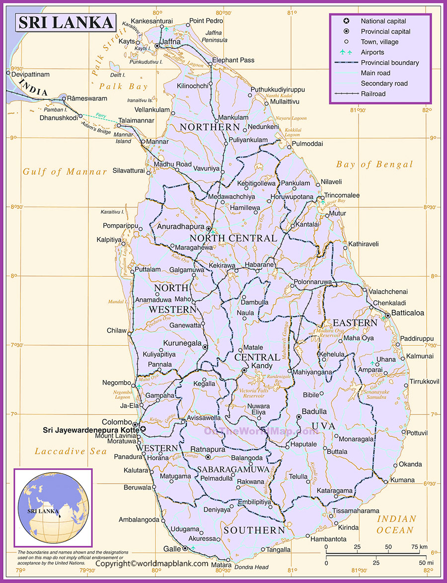
Labeled Map of Sri Lanka with States
Sri Lanka is administratively divided into 9 provinces and 25 districts. In Sri Lankan administrative terminology, provinces and districts are more accurate terms than “states.”
The nine provinces are:
- Central Province
- Eastern Province
- Northern Province
- North Central Province
- North Western Province
- Sabaragamuwa Province
- Southern Province
- Uva Province
- Western Province
This Labeled Sri Lanka Map with States can therefore be understood as a labeled map showing Sri Lanka’s provinces and administrative areas.
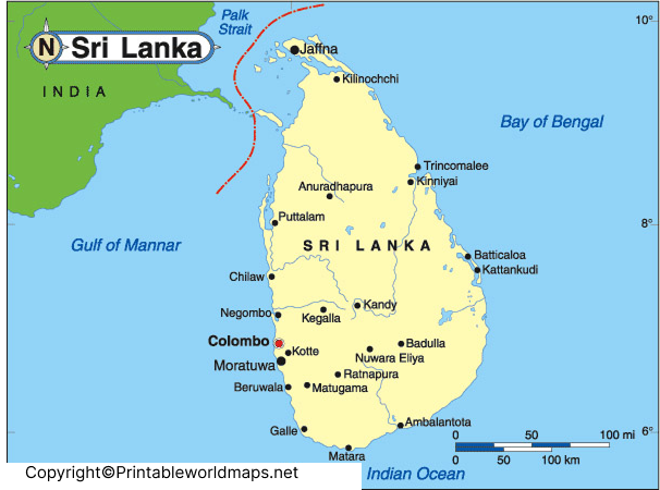
Sri Lanka Map with Cities Labeled
A Sri Lanka map with cities labeled helps readers locate important urban areas and understand their positions across the island.
Cities such as Colombo, Kandy, Galle, Jaffna, Anuradhapura and other major urban centers are useful reference points when studying Sri Lanka’s geography.
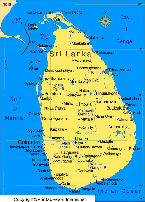
A city-labeled map can be particularly useful for geography lessons, travel planning and understanding the relationship between major cities and administrative areas.
Labeled Sri Lanka Map with Capital
Sri Lanka has an important distinction between its administrative capital and commercial capital.
Sri Jayewardenepura Kotte is the administrative capital, while Colombo is the commercial capital. This distinction is documented by Sri Lanka Tourism’s official country profile.
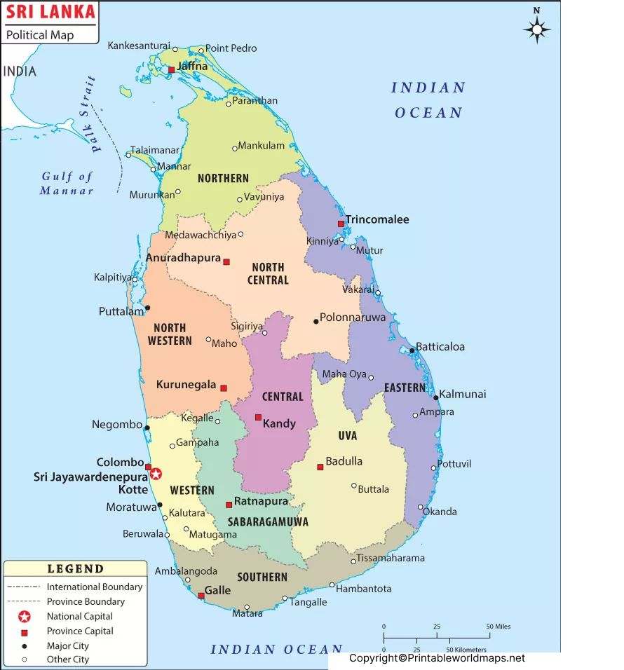
This map is useful for identifying Sri Lanka’s capital and understanding its location relative to other major parts of the country.
Sri Lanka Geography at a Glance
Sri Lanka is located in the Indian Ocean in South Asia. The island covers roughly 65,525 square kilometres, according to Sri Lanka Tourism’s official country profile.
Some useful geographic facts include:
- Region: South Asia
- Location: Indian Ocean
- Administrative capital: Sri Jayewardenepura Kotte
- Commercial capital: Colombo
- Provinces: 9
- Districts: 25
- Highest mountain: Pidurutalagala, 2,524 metres
- Official currency: Sri Lankan Rupee (LKR)
- Population: 21,781,800 according to the 2024 Census
Sri Lanka’s geography includes coastal areas, plains, forests, mountains, tea-growing highlands and diverse natural environments.
Interesting Facts About Sri Lanka
Here are some useful facts that can make a Sri Lanka map easier to understand:
1. Sri Lanka Has 9 Provinces
The country is divided into nine provinces and 25 districts. This administrative structure is useful when reading a political or provincial map.
2. Colombo and Sri Jayewardenepura Kotte Have Different Roles
Colombo is identified as Sri Lanka’s commercial capital, while Sri Jayewardenepura Kotte is the administrative capital.
3. Sri Lanka Is an Island Country
Sri Lanka lies in the Indian Ocean and is geographically part of South Asia.
4. The Country Has Diverse Landscapes
Sri Lanka includes beaches, coastal plains, forests, mountains, waterfalls and tea-growing areas. Its central highlands are particularly known for tea plantations and mountainous landscapes.
5. The 2024 Census Provides Updated Population Data
Sri Lanka’s 2024 Census recorded 21,781,800 people, making it preferable to use this official census figure instead of the older “over 21 million” wording in the original article.
Frequently Asked Questions
What is the capital of Sri Lanka?
Sri Jayewardenepura Kotte is the administrative capital of Sri Lanka, while Colombo is the country’s commercial capital.
How many provinces are there in Sri Lanka?
Sri Lanka has 9 provinces and 25 districts.
Is Colombo the capital of Sri Lanka?
Colombo is the commercial capital of Sri Lanka. Sri Jayewardenepura Kotte is the administrative capital.
What is the population of Sri Lanka?
Sri Lanka’s 2024 Census reported a population of 21,781,800 at the census reference time of December 19, 2024.
Where is Sri Lanka located?
Sri Lanka is an island country located in the Indian Ocean in South Asia.
What are the administrative divisions of Sri Lanka?
Sri Lanka is divided into 9 provinces and 25 districts. Districts are further divided into lower-level administrative areas.
What is the highest mountain in Sri Lanka?
Pidurutalagala is Sri Lanka’s highest mountain, with an elevation of approximately 2,524 metres according to Sri Lanka Tourism.
Can I print the Sri Lanka maps?
Yes. The maps provided above include downloadable image and PDF versions that can be used for educational and reference purposes, subject to the applicable source and copyright terms.
Reference Links
https://www.statistics.gov.lk/Population/StaticalInformation/CPH2024
https://www.statistics.gov.lk/Resource/en/Population/CPH_2024/CPH2024_Final_Eng.pdf
https://srilanka.travel/research_tourism/research_tourism/srilanka-at-a-glance
https://srilanka.travel/tourist-map
