

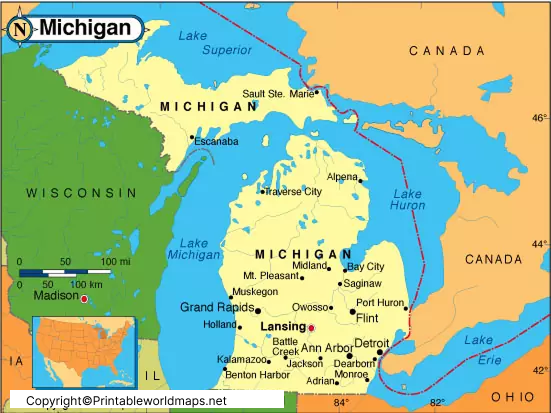
A Labeled Map of Michigan helps you locate the state capital, major cities, counties, highways, and surrounding Great Lakes. Michigan is located in the Great Lakes region of the United States and consists of two distinct peninsulas: the Upper Peninsula and the Lower Peninsula. Its capital is Lansing, while Detroit is its largest city by population.
On this page, you can explore printable Michigan maps showing cities, the state capital, and important geographic features. Use these maps for school projects, geography lessons, travel planning, and general reference.
Labeled Map of Michigan
A labeled map of Michigan identifies the state’s location, boundaries, capital city, major population centers, and important physical features. Depending on the map, it may also show highways, rivers, county boundaries, and surrounding lakes.
Michigan covers approximately 96,714 square miles of total area, including land and water. According to the U.S. Census Bureau, its 2020 census population was 10,077,331, while the bureau’s July 2025 population estimate was 10,127,884.
Michigan became the 26th U.S. state on January 26, 1837. It is widely known as the Wolverine State and is surrounded by the Great Lakes region’s distinctive freshwater geography.

Labeled Map of Michigan Printable
A printable Michigan map is useful for students, teachers, researchers, and travelers who need a clear geographic reference. A labeled version can help you identify cities, counties, rivers, and other important features without having to consult several different maps.
For classroom use, print the map on standard paper and use it to practice locating Michigan’s capital, identifying the two peninsulas, or marking the Great Lakes. For travel planning, a map that includes highways and major cities can help you understand the state’s overall layout.

Printing tip: Choose the PDF version for printing when available. Check the page orientation and print preview before printing so that labels and state boundaries remain easy to read.
Labeled Michigan Map with Cities
A labeled Michigan map with cities helps readers understand where the state’s major urban areas are located. Detroit is Michigan’s largest city by population. Other well-known cities include Grand Rapids, Warren, Sterling Heights, Ann Arbor, Lansing, Dearborn, Livonia, and Flint.
Detroit is located in southeastern Michigan near the Canadian border, across the Detroit River from Windsor, Ontario. Grand Rapids lies farther west, while Lansing is situated inland in the south-central part of the Lower Peninsula.
Ann Arbor is known for the University of Michigan, and Flint is another important city in the state’s southeastern region. The exact cities shown on a map depend on its scale and level of detail.

Labeled Michigan Map with Capital
Lansing is the capital of Michigan and has served as the state capital since 1847. It is located in Ingham County, in the southern part of the Lower Peninsula. Detroit was the original territorial and early state capital before the government moved to Lansing.
The Michigan State Capitol building in Lansing opened on January 1, 1879, and is recognized as a National Historic Landmark. Lansing is also part of a regional center for government, education, manufacturing, and business.
When reading a Michigan capital map, look for Lansing in the southern Lower Peninsula. Do not confuse the state capital with Detroit, which is the state’s largest city by population.
Michigan’s Two Peninsulas and the Great Lakes
One of Michigan’s most distinctive geographic features is its division into two peninsulas. The Lower Peninsula is often described as mitten-shaped, while the Upper Peninsula extends westward from the Straits of Mackinac.
Michigan borders four of the five Great Lakes: Lake Superior, Lake Michigan, Lake Huron, and Lake Erie. Lake Ontario does not border the state. The Straits of Mackinac connect Lake Michigan and Lake Huron and separate the two peninsulas.
These waterways are important for understanding Michigan’s geography, transportation, tourism, and natural environment. A physical or regional map can make the relationship between the lakes and the state’s two peninsulas easier to understand.
Michigan Counties Map
Michigan has 83 counties. County boundaries are useful for locating local governments, understanding administrative divisions, and identifying the county associated with a city or community.
For example, Lansing is in Ingham County, Detroit is in Wayne County, and Grand Rapids is in Kent County. Marquette County is in the Upper Peninsula, while Oakland County is in southeastern Michigan.
The largest county by land area and the most populous county are not necessarily the same. County rankings can also change depending on whether land area, total area, or population is being measured.
For authoritative county boundaries and county names, consult the official Michigan county map.
Important Facts About Michigan
Here are several verified facts that can help readers understand the state shown on a labeled Michigan map:
- Capital: Lansing.
- Largest city by population: Detroit.
- Statehood: January 26, 1837.
- Statehood order: 26th state to join the United States.
- Number of counties: 83.
- Nickname: The Wolverine State.
- Geographic layout: Upper Peninsula and Lower Peninsula.
- Great Lakes bordering Michigan: Superior, Michigan, Huron, and Erie.
- 2020 census population: 10,077,331.
- July 2025 population estimate: 10,127,884.
Population figures are tied to their stated reference dates. For the latest official estimates, use the U.S. Census Bureau’s Michigan QuickFacts page.
How to Use a Labeled Map of Michigan
A labeled Michigan map can support several practical activities:
- Learn state geography: Find Lansing, Detroit, Grand Rapids, and other cities.
- Study the Great Lakes: Identify the four Great Lakes that border Michigan.
- Practice county locations: Use a county map to understand local administrative boundaries.
- Plan a trip: Consult a road map for highways, distances, and routes.
- Complete school assignments: Print a suitable map and label geographic features for practice.
Before using a map for navigation, check whether it includes current roads and transportation information. A general educational map may not show recent road changes or all local routes.
Frequently Asked Questions
What is the capital of Michigan?
Lansing is the capital of Michigan. It has served as the state capital since 1847 and is located in Ingham County.
What is the largest city in Michigan?
Detroit is Michigan’s largest city by population. It is located in southeastern Michigan near the international border with Canada.
How many counties are in Michigan?
Michigan has 83 counties. An official county map can help you identify their names and locations.
What are the two peninsulas of Michigan?
Michigan consists of the Upper Peninsula and the Lower Peninsula. The Straits of Mackinac separate them.
Which Great Lakes border Michigan?
Michigan borders Lake Superior, Lake Michigan, Lake Huron, and Lake Erie. Lake Ontario does not border Michigan.
Can I download a printable map of Michigan?
Yes. The map links above include PNG images and PDF files. PDFs are generally convenient for printing, while PNG files are useful for viewing or inserting into digital documents.
Where can I find an official Michigan road map?
The Michigan Department of Transportation provides state transportation maps and related mapping resources through its official website.
What is Michigan known for geographically?
Michigan is known for its two peninsulas, extensive Great Lakes shoreline, inland lakes, rivers, forests, and distinctive mitten-shaped Lower Peninsula.
Reference links
https://www.michigan.gov/en/About-Michigan/State-Facts-and-Symbols
https://www.census.gov/quickfacts/fact/table/MI/BPS030223
https://www.michigan.gov/lara/bureau-list/bchs/adult/online-lookups/michigan-counties-map
https://www.michigan.gov/mdot/travel/maps
https://en.wikipedia.org/wiki/Michigan
https://en.wikipedia.org/wiki/Geography_of_Michigan

1 thought on “Labeled Map of Michigan with Capital & Cities”