

The Labeled Map of Massachusetts helps you locate the state capital, major cities, counties, rivers, and important geographic features of Massachusetts, United States. Whether you are a student, teacher, traveler, or geography enthusiast, these printable maps make it easier to understand the state’s location and regional layout.
Massachusetts is located in the northeastern United States and is part of the New England region. It borders New Hampshire and Vermont to the north, New York to the west, Connecticut and Rhode Island to the south, and the Atlantic Ocean to the east. Its capital and largest city is Boston.
Explore the labeled maps below to identify important places, study state geography, and download a map for educational or personal reference.
Labeled Map of Massachusetts
A labeled map of Massachusetts provides a visual overview of the state’s boundaries, cities, towns, waterways, and transportation routes, depending on the map version. It is useful for school assignments, geography lessons, trip planning, and general reference.
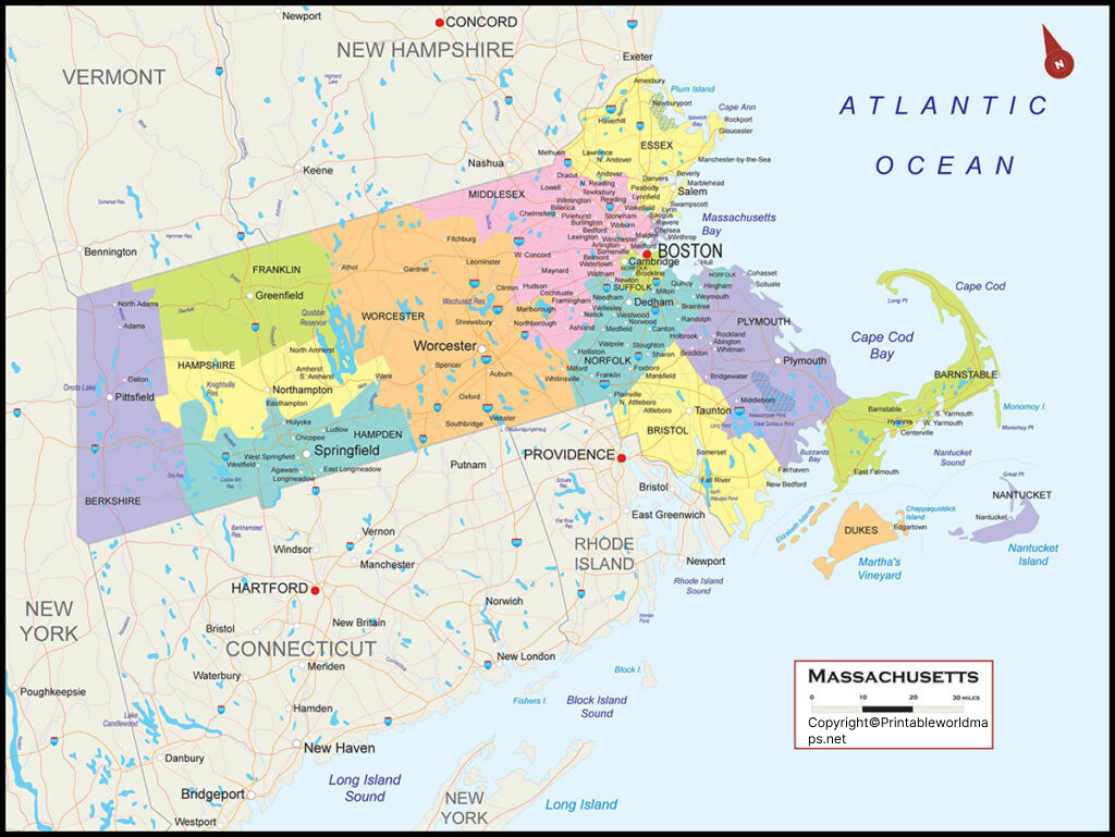
Massachusetts is one of the smallest U.S. states by land area, but it has a varied landscape that includes coastal communities, inland hills, river valleys, and the mountainous Berkshire region in the west.
According to the U.S. Census Bureau, Massachusetts had a population of 7,029,917 in the 2020 Census. Its estimated population reached 7,154,084 on July 1, 2025. Use the Census Bureau’s latest figures when current population information is required.
Labeled Map of Massachusetts Printable
A printable Massachusetts map is useful for students, educators, researchers, and anyone who needs a clear geographic reference. A PDF version is especially convenient for printing, classroom activities, and offline use.
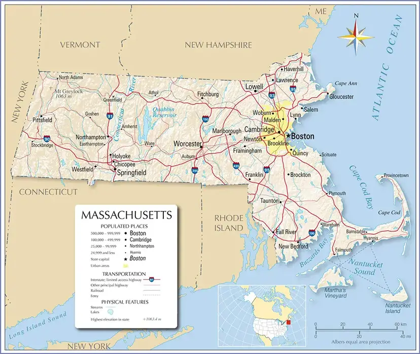
Before printing, check the map’s labels and scale to ensure that the place names are readable at your selected paper size. For classroom use, you can ask students to identify Boston, neighboring states, major rivers, and the Atlantic coastline.
How to Use a Printable Massachusetts Map
- For students: Identify the state capital, neighboring states, and major cities.
- For teachers: Use the map for geography quizzes, classroom activities, and state-location exercises.
- For travelers: Understand the general locations of cities and coastal areas before planning a trip.
- For researchers: Use labeled geographic features as a starting point for further study.
A general reference map should not be used as a substitute for current road maps, navigation directions, property boundaries, or official surveying documents.
Labeled Map of Massachusetts with Cities
The labeled map of Massachusetts with cities helps readers locate important urban centers throughout the state. Boston is the state capital and the largest city by population. Other major cities include Worcester, Springfield, Cambridge, Lowell, and Brockton.
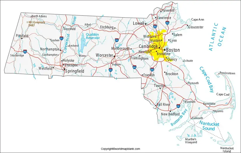
The 2020 Census recorded the following populations for several of Massachusetts’ largest cities:
| City | Population (2020 Census) |
|---|---|
| Boston | 675,647 |
| Worcester | 206,518 |
| Springfield | 155,929 |
| Cambridge | 118,403 |
| Lowell | 115,554 |
| Brockton | 105,643 |
These figures are from the 2020 Census, not current population estimates. City populations can change over time, so consult the U.S. Census Bureau for newer estimates when needed.
Boston is a major center for education, healthcare, finance, history, and tourism. Worcester is an important regional center in central Massachusetts, while Springfield is a major city in the Connecticut River Valley. Cambridge is widely known for its universities and research institutions.
Labeled Massachusetts Map with Capital
Boston is the capital of Massachusetts and serves as the seat of the state government. Founded in 1630, the city is one of the most historically significant urban centers in the United States.

A map highlighting the capital is useful for understanding Massachusetts’ administrative geography. Boston is located in eastern Massachusetts along the Atlantic coast and is part of the Greater Boston metropolitan area.
Visitors can explore historic sites, museums, waterfront areas, and educational institutions in Boston. However, the city is not the geographic center of the state; it is situated in the eastern part of Massachusetts.
Counties of Massachusetts
Massachusetts has 14 counties: Barnstable, Berkshire, Bristol, Dukes, Essex, Franklin, Hampden, Hampshire, Middlesex, Nantucket, Norfolk, Plymouth, Suffolk, and Worcester.
County boundaries remain useful for identifying regions and organizing geographic information. However, county government in Massachusetts differs from that in many other U.S. states. Seven county governments were abolished between 1997 and 2000, while several others continue to operate. County boundaries and county governments should therefore not be treated as the same thing.
Major Rivers and Geographic Features of Massachusetts
Massachusetts includes several important rivers, reservoirs, coastal areas, and upland regions. The Connecticut River runs through western Massachusetts and the Connecticut River Valley. Other notable waterways include the Merrimack, Charles, Housatonic, Deerfield, and Taunton rivers.
The state also contains the Berkshire Mountains in the west, the central uplands, the Atlantic coastline, Cape Cod, Martha’s Vineyard, and Nantucket. These features contribute to the state’s varied geography and regional character.
For additional geographic information, the Massachusetts Office of Travel and Tourism provides an overview of the state’s geography and natural features.
Interesting Facts About Massachusetts
- State capital: Boston.
- Common nickname: The Bay State.
- Region: New England, in the northeastern United States.
- Statehood: Massachusetts became the sixth U.S. state on February 6, 1788.
- Population: 7,029,917 in the 2020 Census.
- 2025 population estimate: 7,154,084, according to the U.S. Census Bureau.
- Counties: Massachusetts has 14 counties, although several no longer have county governments.
- Highest point: Mount Greylock, in the Berkshire region.
- Geographic diversity: The state includes Atlantic coastal areas, islands, river valleys, inland communities, and mountainous terrain.
These facts provide useful context when reading a labeled map of Massachusetts and identifying its important cities and physical features.
How to Download and Print a Massachusetts Map
Follow these simple steps to use the map for schoolwork, reference, or personal study:
- Choose the map that best matches your needs, such as a city map or a capital map.
- Open the image or PDF link provided above.
- Download or save the file to your device.
- Open the downloaded file and check that the labels are readable.
- Select your preferred paper size and print settings before printing.
PDF files are generally convenient for printing, while image files can be useful for viewing or inserting into educational materials. Check the source and any applicable usage permissions before republishing a map on another website.
Frequently Asked Questions
What is the capital of Massachusetts?
Boston is the capital of Massachusetts. It is located in the eastern part of the state and serves as the seat of state government.
What are the largest cities in Massachusetts?
Boston, Worcester, Springfield, Cambridge, Lowell, and Brockton are among the state’s largest cities by population. Their rankings can change when newer population estimates are released.
How many counties are there in Massachusetts?
Massachusetts has 14 counties. However, several county governments were abolished between 1997 and 2000, while the county boundaries remain.
Where can I download a printable map of Massachusetts?
You can use the printable map image and PDF links provided in the sections above. Choose the version that best suits your needs and check the labels before printing.
Which states border Massachusetts?
Massachusetts borders New Hampshire and Vermont to the north, New York to the west, and Connecticut and Rhode Island to the south. The Atlantic Ocean lies to the east.
What are the major rivers in Massachusetts?
Major rivers include the Connecticut, Merrimack, Charles, Housatonic, Deerfield, and Taunton rivers. Their locations can help readers understand the state’s physical geography.
What is Massachusetts known for?
Massachusetts is known for its colonial history, educational institutions, healthcare and research centers, coastal communities, and historic landmarks. Boston is a major destination for visitors interested in American history and culture.
Is a labeled Massachusetts map useful for students?
Yes. A labeled map can help students learn the state’s capital, cities, neighboring states, counties, and geographic features. It can also support classroom assignments and geography quizzes.
Reference links
https://www.census.gov/quickfacts/fact/table/MA/BZA210222
https://www.sec.state.ma.us/divisions/cis/historical/profile.htm
https://www.sec.state.ma.us/divisions/cis/government/politics-counties.htm
https://www.sec.state.ma.us/divisions/cis/government/gov-county.htm
https://www.visitma.com/massachusetts-facts-and-stats/
https://malegislature.gov/Laws/GeneralLaws/PartI/TitleVI/Chapter34B/Section1
