
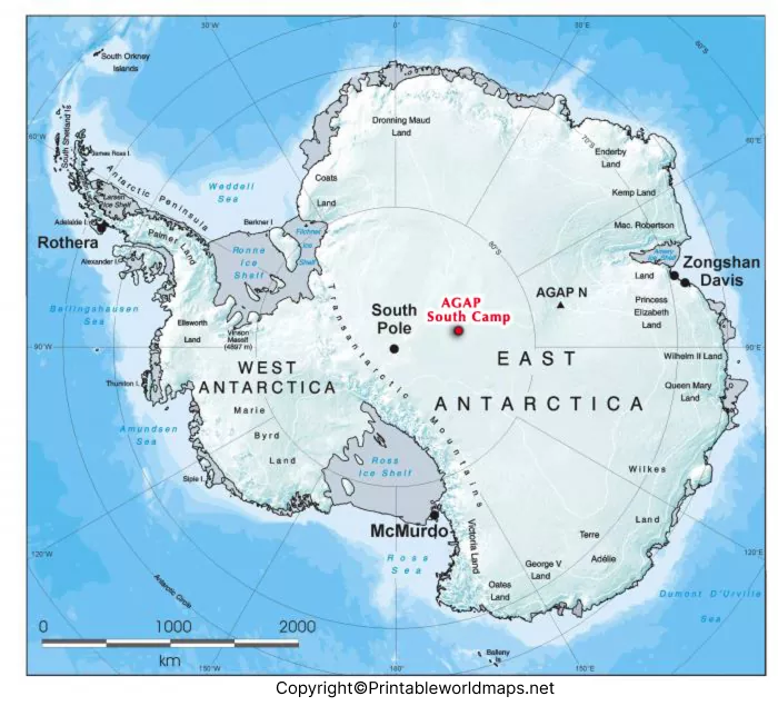

Discover all the available mountains of Africa with our map of Antarctica mountains easily and plan your visit to the content accordingly. We are here going to provide the physical geographical template of Antarctica template for the ease of our readers.
- World coronavirus map
- World geographical map
- World map for kids
- World Map Wallpaper
- World population map
- Accurate map of World
- Ancient World map
Antarctica Mountains Map
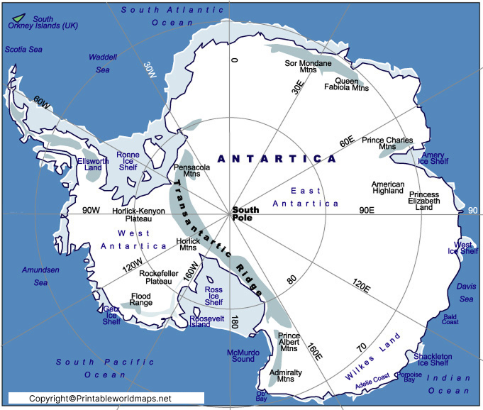
Antarctica Mountains Map helps students, researchers, travelers, and geography enthusiasts explore the major mountain ranges and highest peaks across Antarctica. Although Antarctica is famous for its vast ice sheets, the continent also contains some of the world’s most remarkable mountain systems, many of which remain hidden beneath thick layers of ice.
This detailed map of Antarctica mountains highlights the major mountain ranges, important peaks, and geographical regions, making it an excellent educational resource for schools, colleges, map lovers, and researchers interested in Earth’s southernmost continent.
Antarctica Mountains Map: Major Mountain Ranges
The Antarctica Mountains Map displays several significant mountain systems spread across the continent. These mountains play an important role in Antarctica’s geology, climate, and glaciology.
Some of the most notable mountain ranges include:
- Transantarctic Mountains – One of the longest mountain ranges on Earth, stretching approximately 3,500 km (2,200 miles) and dividing East Antarctica from West Antarctica.
- Ellsworth Mountains – Home to Vinson Massif, the highest mountain in Antarctica.
- Sentinel Range – Located within the Ellsworth Mountains and containing several of Antarctica’s tallest peaks.
- Heritage Range – Another important section of the Ellsworth Mountains.
- Prince Charles Mountains
- Queen Maud Mountains
- Gamburtsev Subglacial Mountains – A hidden mountain range buried beneath Antarctica’s ice sheet.
- Pensacola Mountains
- Shackleton Range
Each of these mountain systems has unique geological characteristics and scientific importance.
Map of Antarctica Mountains
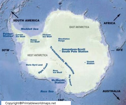
The Map of Antarctica Mountains provides a clear overview of the continent’s rugged terrain despite nearly 98% of Antarctica being covered by ice.
One of the most famous landmarks shown on the map is Vinson Massif, which rises to approximately 4,892 meters (16,050 feet) above sea level, making it the highest peak in Antarctica.
The Transantarctic Mountains divide the continent into East Antarctica and West Antarctica, making them one of the most important geographical features on the continent.
Scientists study these mountain ranges to understand:
Ancient rock formations
Earth’s geological history
Ice sheet movement
Climate change
Glacier dynamics
Printable Antarctica Mountains Map Labeled
A Printable Antarctica Mountains Map Labeled is perfect for classroom learning, geography assignments, competitive exam preparation, and scientific studies.
Our printable map clearly identifies:
Research station locations (where applicable)
Major mountain ranges
Highest peaks
Important glaciers
Geographic regions
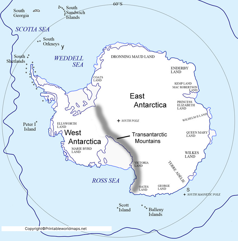
Teachers can use the map during geography lessons, while students can print it for projects, homework, or map practice.
Mountains Map of Antarctica
Our readers can here check out the printable template of the Antarctica mountains map. This printable map template is useful to use as the full-fledged mountain map of the continent. You can easily print it from here and then use it to have a decent look at the Antarctica mountains. If you are a scholar then you can use it as the physical map of Antarctica for your learnings.
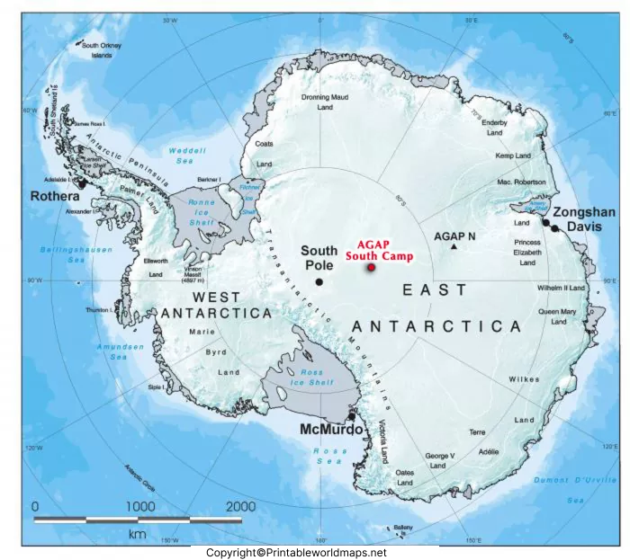
Furthermore, you can also use it for your tourist purpose if you are an explorer. Feel free to get both the printable and digital format of the template. We believe it would save you significant time and money with its decent availability and compatibility.
Why Use an Antarctica Mountains Map?
An Antarctica Mountains Map is useful for many purposes, including:
- Geography education
- School and college projects
- Research on Antarctic landforms
- Expedition planning
- Physical geography studies
- Cartography and map practice
- General knowledge preparation
Whether you are a teacher, student, traveler, or researcher, a detailed mountain map makes it easier to understand Antarctica’s unique landscape.
Interesting Facts About Antarctica Mountains
Here are some fascinating facts:
- Antarctica is the fifth-largest continent on Earth.
- Around 98% of Antarctica is covered by ice.
- The continent contains about 70% of the world’s freshwater locked in ice.
- Vinson Massif is Antarctica’s highest mountain at 4,892 m (16,050 ft).
- The Transantarctic Mountains extend for approximately 3,500 km, making them among the world’s longest mountain ranges.
- Some mountain ranges, including the Gamburtsev Subglacial Mountains, remain completely buried beneath thick ice.
- Antarctica has no permanent human population, but thousands of researchers live there seasonally at scientific research stations.
Frequently Asked Questions (FAQs)
What is the highest mountain in Antarctica?
The highest mountain is Vinson Massif, with an elevation of approximately 4,892 meters (16,050 feet).
What is the longest mountain range in Antarctica?
The Transantarctic Mountains are the longest mountain range in Antarctica, extending about 3,500 kilometers (2,200 miles).
Are Antarctica’s mountains covered by ice?
Yes. Most Antarctic mountains are partially or completely covered by glaciers and thick ice sheets, although some rocky peaks called nunataks rise above the ice.
Can tourists visit Antarctica’s mountains?
Yes, but only through specialized Antarctic expeditions. Access is limited due to extreme weather conditions and strict environmental protection regulations under the Antarctic Treaty System.
Conclusion
The Antarctica Mountains Map is an essential educational and geographical resource for understanding one of Earth’s most fascinating landscapes. From the massive Transantarctic Mountains to Vinson Massif, the continent’s mountain systems provide valuable insights into geology, climate science, and polar exploration. Whether you need a printable labeled map for classroom use or a detailed reference for research, this guide offers accurate and reliable information to support your learning.
