
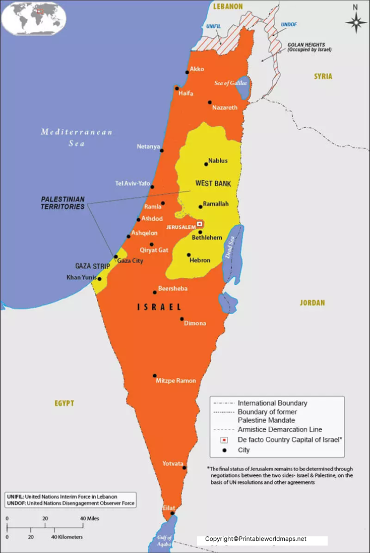
A Labeled Map of Israel helps readers identify the country’s location, major cities, administrative districts, capital, neighboring areas, and important geographic features. Israel is located in the Middle East along the eastern Mediterranean coast.
Israel’s geography includes coastal plains, mountain regions, the Jordan Rift Valley, and the Negev Desert. Because maps can use different political and geographic boundaries, disputed areas should be interpreted according to the map’s stated source and date.
This collection includes a labeled map of Israel, a map showing administrative districts, a map with major cities, and a capital-focused map. Printable and PDF versions are provided for educational, geographic, and reference purposes.
- World map with continents
- Physical world map
- Political world map
- Labeled map of Asia
- Labeled map of Africa
- Labeled map of Europe
- Labeled map of South America
- World time zone map
- Labeled map of world
- Blank map of world
- Labeled map of North America
- Blank map of Asia
- World map with oceans
- World map poster
Labeled Map of Israel
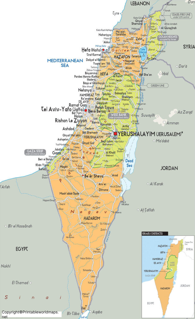
The Labeled Map of Israel identifies important geographic locations and provides a quick visual reference for studying the country.
Israel has a Mediterranean coastline to the west. It shares land boundaries with Lebanon to the north, Syria to the northeast, Jordan to the east, and Egypt to the southwest. The political status and boundaries of some territories in and around Israel are subject to international dispute, so maps may differ depending on the source and purpose.
Labeled Map of Israel with States
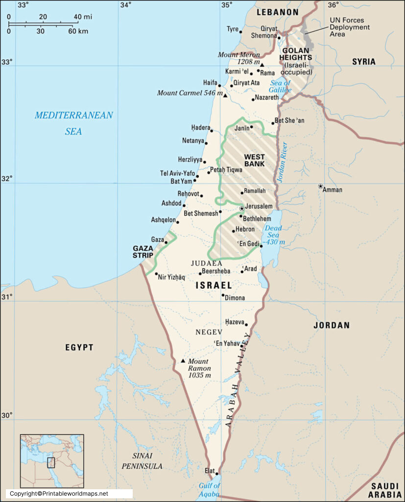
Israel does not officially divide the country into states in the same way as countries such as the United States or India. For administrative purposes, Israel is divided into six main districts: Central, Haifa, Jerusalem, Northern, Southern, and Tel Aviv.
Therefore, a Labeled Map of Israel with States is more accurately understood as a map showing Israel’s administrative districts.
The six districts are:
| Administrative District | Administrative Center |
|---|---|
| Central District | Ramla |
| Haifa District | Haifa |
| Jerusalem District | Jerusalem |
| Northern District | Nazareth |
| Southern District | Beersheba |
| Tel Aviv District | Tel Aviv |
Administrative centers and district boundaries can be useful when studying Israel’s government structure and geography.
Labeled Map of Israel with Cities
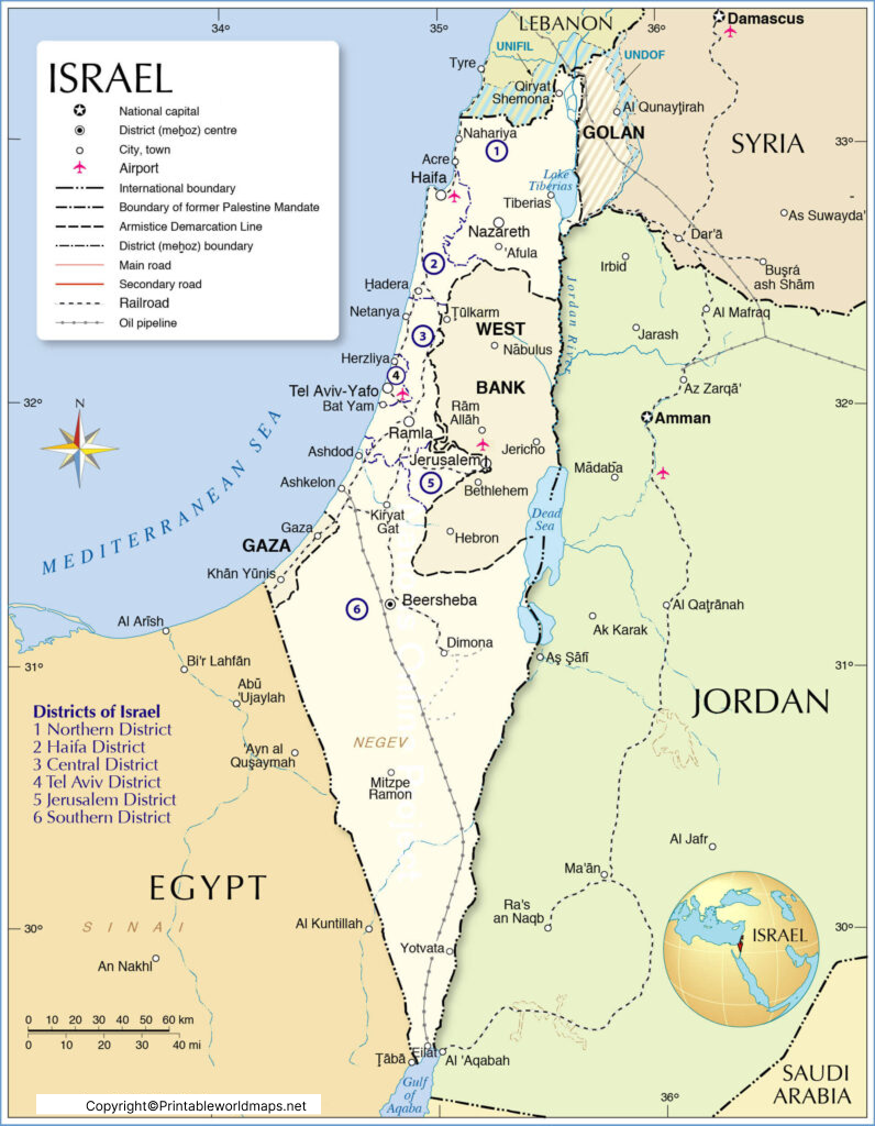
A Labeled Map of Israel with Cities makes it easier to locate major urban centers and understand their geographic distribution.
Important cities and urban areas commonly shown on maps of Israel include Jerusalem, Tel Aviv-Yafo, Haifa, Beersheba, Rishon LeZion, Petah Tikva, Ashdod, Netanya, Holon, Bnei Brak, Ramat Gan, Ashkelon, Rehovot, Bat Yam, Beit Shemesh, and Kfar Saba.
Jerusalem is located in the country’s central highland region, while Tel Aviv-Yafo lies on the Mediterranean coast. Haifa is an important northern coastal city, and Beersheba is a major urban center in the Negev.
Labeled Israel Map with Capital
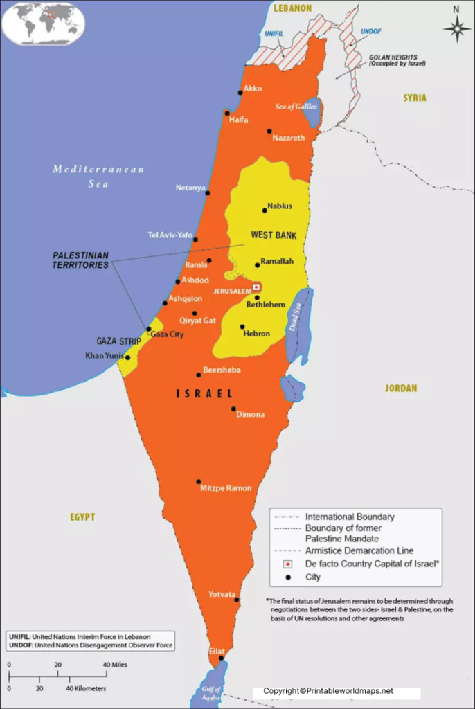
The Labeled Israel Map with Capital identifies Jerusalem, which Israel designates as its capital.
Jerusalem is a historically significant city and an important religious center for Judaism, Christianity, and Islam. Its political status is internationally contested, and different governments and international organizations use different terminology when discussing Jerusalem and its status.
Israel Geography and Location
Israel is situated along the eastern Mediterranean. Its geographic position connects the Mediterranean region with the Middle East.
Key geographic features include:
- Mediterranean Sea – west of Israel
- Jordan River – an important river in the region
- Dead Sea – located along the Israel-Jordan border
- Sea of Galilee – an important freshwater lake in northern Israel
- Negev Desert – covers a large part of southern Israel
- Galilee – a mountainous region in northern Israel
- Coastal Plain – contains many of Israel’s major population centers
The country’s geography varies considerably from the Mediterranean coast to the mountainous interior and arid southern desert.
Major Cities Shown on an Israel Map
Jerusalem
Jerusalem is Israel’s designated capital and one of the world’s most historically significant cities. It is an important religious and cultural center.
Tel Aviv-Yafo
Tel Aviv-Yafo is a major coastal city and a significant economic, technological, and cultural center.
Haifa
Haifa is a major port city on Israel’s northern Mediterranean coast and is situated around Mount Carmel.
Beersheba
Beersheba is an important city in southern Israel and is often associated with the Negev region.
Eilat
Eilat is located at the southern tip of Israel on the Red Sea and is known for its coastal and tourism-related activities.
Israel Administrative Districts
For geographic reference, Israel’s six administrative districts are:
- Central District
- Haifa District
- Jerusalem District
- Northern District
- Southern District
- Tel Aviv District
These districts are administrative divisions rather than “states.” Using the term administrative districts provides more precise geographic terminology.
Interesting Facts About Israel
Israel’s administrative structure includes six main districts.
Israel is located on the eastern coast of the Mediterranean Sea.
Jerusalem is designated by Israel as its capital.
Tel Aviv-Yafo is one of the country’s major coastal urban centers.
The Negev Desert occupies a substantial part of southern Israel.
The Dead Sea is one of the lowest exposed land areas on Earth.
Israel has a highly varied landscape despite its relatively small geographic area.
Hebrew and Arabic are both used in Israel’s public and governmental environment, with Hebrew being the country’s official language and Arabic having a special status under Israeli law.
Why Use a Labeled Map of Israel?
A labeled map can be useful for:
- Students studying Middle Eastern geography
- Teachers preparing geography lessons
- Researchers locating cities and administrative areas
- Travel planning and geographic orientation
- Presentations requiring a clear geographic reference
- Homeschooling and educational worksheets
- Map enthusiasts studying political and physical geography
For educational use, it is useful to compare a labeled political map with a physical map to understand both administrative boundaries and natural features.
Israel Map: Political Boundaries and Map Accuracy
Political maps of Israel can differ because the status and boundaries of certain areas are disputed. For this reason, readers should check the publication date, map source, and labeling conventions when using a map for research or educational work.
For current geographic or political information, authoritative sources such as the United Nations, Israel Central Bureau of Statistics, and other official geographic resources should be consulted alongside a printable reference map.
Frequently Asked Questions
What is the main keyword for this Israel map?
The main SEO keyword is Labeled Map of Israel.
What are the six districts of Israel?
The six main administrative districts are Central, Haifa, Jerusalem, Northern, Southern, and Tel Aviv.
What is the capital of Israel?
Israel designates Jerusalem as its capital. The international status of Jerusalem is subject to dispute.
Does Israel have states?
Israel does not have states as its primary administrative divisions. It is divided into six main administrative districts.
What are the major cities in Israel?
Major cities include Jerusalem, Tel Aviv-Yafo, Haifa, Beersheba, Rishon LeZion, Petah Tikva, Ashdod, Netanya, and Eilat, among others.
Where is Israel located?
Israel is located in the Middle East along the eastern Mediterranean coast.
Can I download a printable Israel map?
Yes. Printable PDF versions of the maps can be provided for educational and reference purposes.
Why can different maps of Israel look different?
Maps can use different boundary conventions, geographic classifications, and treatments of areas whose political status is disputed. Checking the map’s source and date helps explain these differences.









