
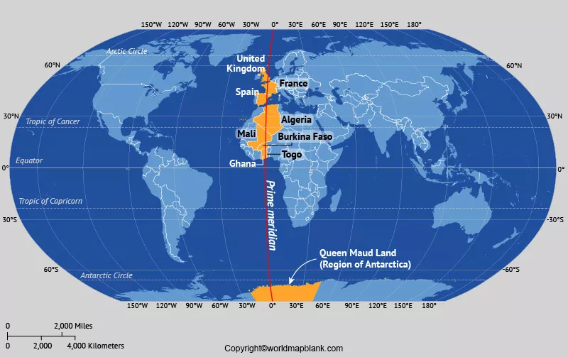

The Prime Meridian Map shows the line of 0° longitude used as the reference for measuring locations east and west around the Earth. The internationally recognized Greenwich meridian passes through the Royal Observatory in Greenwich, London, United Kingdom. It provides a common starting point for geographic coordinates and helps explain how the Eastern and Western Hemispheres are represented on a world map.
On this page, you can explore world maps showing the Prime Meridian, view labeled map images, and access printable PDF versions for geography lessons, school projects, and personal reference.
- World coronavirus map
- World geographical map
- World Map Wallpaper
- World population map
- Accurate map of World
- Ancient World map
World Map with Prime Meridian
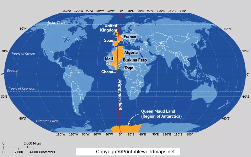
A world map with the Prime Meridian helps you identify the 0° longitude line and understand its relationship with the Equator. The Prime Meridian runs from the North Pole to the South Pole, while the Equator circles the Earth at 0° latitude.
These two reference lines help divide the globe into geographic hemispheres. The Equator separates the Northern and Southern Hemispheres, while the Prime Meridian and its opposite meridian at 180° longitude provide a conventional division between the Eastern and Western Hemispheres.
The map is useful for learning about latitude, longitude, global positioning, and the location of continents and countries in relation to these reference lines.
Prime Meridian Map Labeled
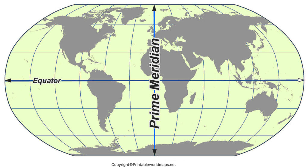
A labeled Prime Meridian Map makes it easier to identify the zero-degree longitude line and understand how longitude is measured. Longitude is expressed in degrees east or west of the selected reference meridian, ranging from 0° to 180° in either direction.
The Prime Meridian forms one half of a great circle around Earth. Its opposite half follows the 180° meridian, commonly called the antimeridian. The International Date Line generally follows this region, although it bends in several places to accommodate political boundaries and local arrangements.
A labeled map is particularly useful for students studying world geography, teachers preparing classroom materials, and anyone learning to interpret geographic coordinates.
Prime Meridian Map
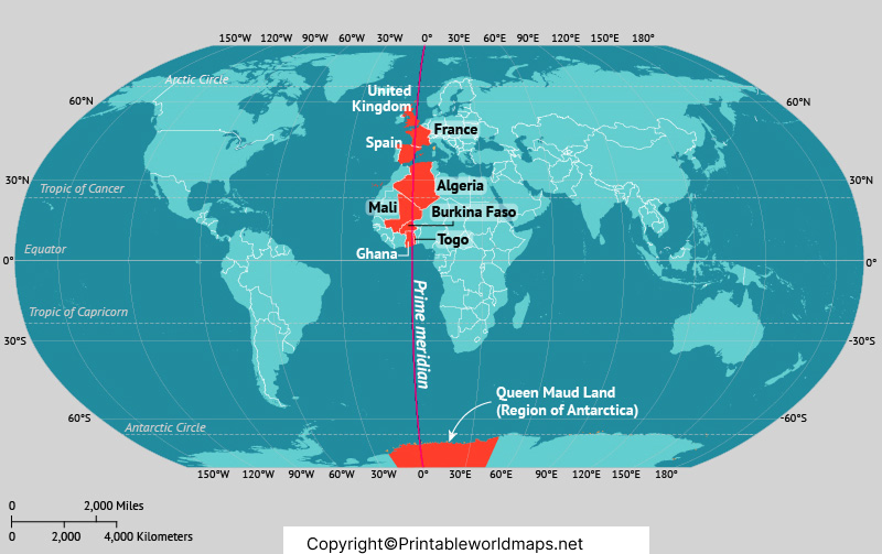
The Prime Meridian is an internationally agreed reference for longitude. It passes through the historic Royal Observatory in Greenwich and continues south through parts of Europe and Africa before crossing the Atlantic Ocean and reaching Antarctica.
The historic Greenwich meridian became the internationally recognized Prime Meridian following the International Meridian Conference in 1884. Before that agreement, different countries used different reference meridians on their maps and navigation charts.
The line crosses eight countries in Europe and Africa: the United Kingdom, France, Spain, Algeria, Mali, Burkina Faso, Togo, and Ghana. It also crosses Antarctica. The exact path shown on a map depends on the geographic reference system used.
Map of the World with Prime Meridian
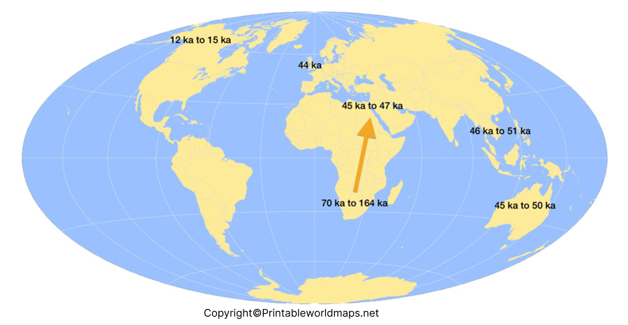
A map of the world with the Prime Meridian helps readers see where 0° longitude runs across continents, countries, and oceans. The line crosses the United Kingdom, France, Spain, Algeria, Mali, Burkina Faso, Togo, and Ghana before continuing across the ocean toward Antarctica.
On a standard north-up world map, the Prime Meridian is usually drawn vertically. However, the left and right sides of a map depend on the map projection and layout, so a country’s position on the page should not be used alone to determine its hemisphere.
The Prime Meridian is an important concept in geography because it provides a shared reference for identifying locations. When combined with latitude, longitude can be used to specify a position on Earth’s surface.
What Is the Prime Meridian?
The Prime Meridian is the reference line at 0° longitude. It is used to measure how far east or west a location lies around the Earth. Unlike the Equator, which is determined by Earth’s rotation, the Prime Meridian is a convention chosen to provide a common geographic reference.
The historic Greenwich meridian was selected internationally in 1884. It was widely used in navigation and mapping, making it a practical choice for establishing a common standard.
For a technical distinction, modern satellite-based coordinate systems use the International Reference Meridian, which lies about 102 metres east of the historic Greenwich Observatory line. Therefore, GPS coordinates may not show precisely 0° longitude when you stand on the historic brass line at Greenwich.
Difference Between the Prime Meridian and the Equator
The Prime Meridian and the Equator are two fundamental reference lines used in geography, but they measure different directions.
- Prime Meridian: Located at 0° longitude, it provides the starting point for measuring positions east and west.
- Equator: Located at 0° latitude, it provides the starting point for measuring positions north and south.
Together, these reference lines help define geographic coordinates. A location’s latitude and longitude can be combined to describe its position on Earth.
Countries Crossed by the Prime Meridian
The Greenwich meridian crosses the following eight countries in Europe and Africa:
- United Kingdom
- France
- Spain
- Algeria
- Mali
- Burkina Faso
- Togo
- Ghana
The line also crosses Antarctica and several bodies of water. These countries are useful reference points when studying a labeled Prime Meridian Map.
Seven Interesting Facts About the Prime Meridian
- Zero degrees longitude: The Prime Meridian is the starting reference for measuring longitude east and west.
- Greenwich, England: The historic Greenwich meridian passes through the Royal Observatory in London.
- International agreement: The Greenwich meridian was selected as the internationally recognized Prime Meridian in 1884.
- Eight countries in Europe and Africa: Its land route crosses the United Kingdom, France, Spain, Algeria, Mali, Burkina Faso, Togo, and Ghana.
- The Equator is different: The Equator marks 0° latitude, while the Prime Meridian marks 0° longitude.
- The opposite meridian: The 180° meridian lies opposite the Prime Meridian and is associated with the general region of the International Date Line.
- GPS coordinates: Modern satellite-based positioning uses a reference meridian slightly east of the historic Greenwich line.
How to Use a Prime Meridian Map for Learning
A Prime Meridian Map can be used for classroom activities, geography assignments, and independent study.
- Locate Greenwich in the United Kingdom.
- Trace the 0° longitude line from the North Pole to the South Pole.
- Identify the countries crossed by the line.
- Compare the Prime Meridian with the Equator.
- Find the 180° meridian on a globe or world map.
- Practice reading latitude and longitude coordinates.
For schoolwork, choose a labeled map when you need country names and a blank map when you want to practice marking locations yourself.
Printable Prime Meridian Map PDF
The printable map PDFs provided above are convenient for offline study, classroom worksheets, presentations, and geography projects. Open the relevant PDF link to check the map layout and print quality before printing.
For the clearest result, use a suitable paper size and the print setting that fits the entire map on the page. If you need to label countries or draw reference lines, select a map version that leaves enough space for annotations.
Frequently Asked Questions About the Prime Meridian Map
1. What is a Prime Meridian Map?
A Prime Meridian Map is a world map that identifies the 0° longitude line. It helps show how locations are measured east and west of the Greenwich reference meridian.
2. Where is the Prime Meridian located?
The historic Prime Meridian passes through the Royal Observatory in Greenwich, London, United Kingdom. The line continues around the Earth from the North Pole to the South Pole.
3. What is the longitude of the Prime Meridian?
The Prime Meridian is located at 0° longitude. Locations east of it are measured in east longitude, while locations west of it are measured in west longitude.
4. What is the difference between the Prime Meridian and the Equator?
The Prime Meridian is at 0° longitude and is used to measure east-west positions. The Equator is at 0° latitude and is used to measure north-south positions.
5. Which countries does the Prime Meridian cross?
The Greenwich meridian crosses the United Kingdom, France, Spain, Algeria, Mali, Burkina Faso, Togo, and Ghana. It also crosses Antarctica and bodies of water.
6. Why is Greenwich important on the world map?
Greenwich is important because its historic meridian became the internationally recognized reference for 0° longitude in 1884. It helped establish a common standard for maps, navigation, and timekeeping.
7. Is the Prime Meridian the same as the International Date Line?
No. The Prime Meridian is at 0° longitude, while the International Date Line generally follows the region around 180° longitude. The date line bends in places to account for political boundaries and local arrangements.
8. Can I download a Prime Meridian Map in PDF format?
Yes. The PDF links provided in this article let you open printable versions of the maps. Check the layout and print settings before printing.
9. Why does GPS sometimes show a different longitude at Greenwich?
Modern satellite navigation uses a geocentric reference system whose zero-longitude meridian lies about 102 metres east of the historic Greenwich meridian. This explains why GPS coordinates may not show exactly 0° longitude on the historic line.
10. Who can use a Prime Meridian Map?
Students, teachers, geography enthusiasts, and people learning about geographic coordinates can use these maps for lessons, assignments, revision, and general reference.
Conclusion
A Prime Meridian Map is a useful resource for understanding longitude, the Equator, hemispheres, and the location of countries around the world. The labeled maps and printable PDFs on this page can support geography lessons and independent learning.
For further accuracy, compare the maps with trusted geographic and scientific references, especially when using coordinates for navigation or technical work.
Reference links
https://education.nationalgeographic.org/resource/prime-meridian
https://oceanservice.noaa.gov/facts/longitude.html
https://www.rmg.co.uk/stories/time/what-prime-meridian-why-it-greenwich
https://www.royalparks.org.uk/visit/parks/greenwich-park/meridian-line
