
Get a labeled map of Haiti to explore the country’s departments, cities, capital, major geographic features, and location within the Caribbean. This page provides printable Haiti maps and PDF versions that can be useful for geography study, classroom activities, travel research, and general reference.
- World coronavirus map
- World geographical map
- World Map Wallpaper
- World population map
- Accurate map of World
- Ancient World map
Haiti’s first-level administrative divisions are officially called departments, not states. Haiti has 10 departments. The term “states” is retained in the page title because it is part of the existing page title, but the article uses the correct geographic terminology.
Labeled Map of Haiti
Our labeled map of Haiti shows the country’s overall geographic layout and helps identify important places and geographic features.
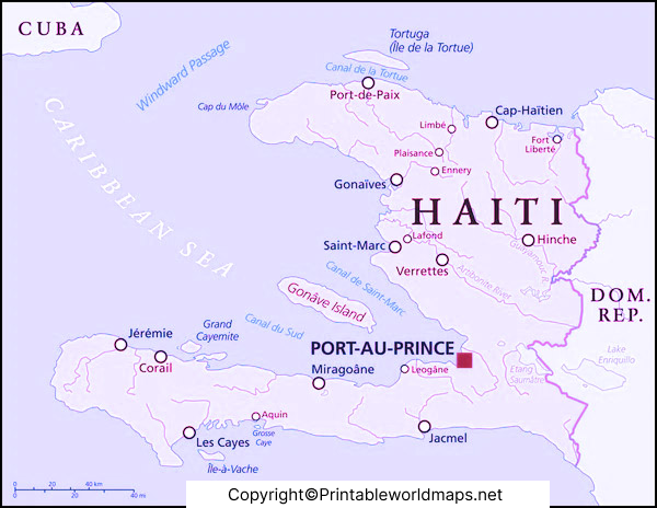
The map can be used to identify Haiti’s position on the island of Hispaniola, which Haiti shares with the Dominican Republic. Haiti occupies the western portion of Hispaniola in the Caribbean.
Haiti has an area of approximately 27,750 square kilometres and its capital city is Port-au-Prince. UN data identifies Haiti as a Caribbean country and lists Port-au-Prince as its capital.
A labeled geographic map is useful for understanding the country’s coastline, mountains, plains, islands, and major population centres.
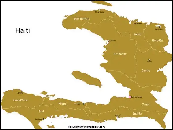
Labeled Map of Haiti with Departments
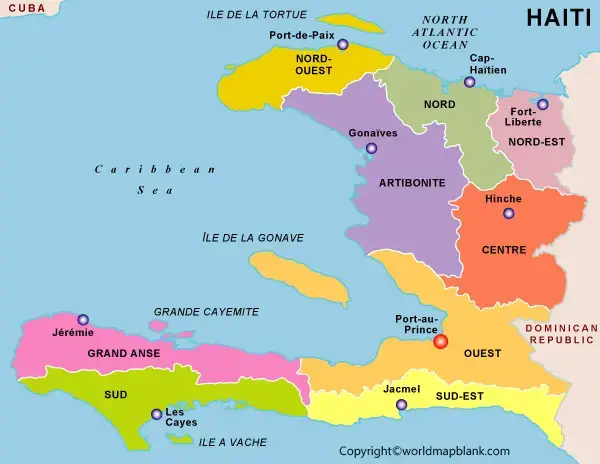
The labeled map of Haiti with departments is useful for studying Haiti’s administrative geography.
Haiti is divided into 10 departments:
- Artibonite
- Centre
- Grand’Anse
- Nippes
- Nord
- Nord-Est
- Nord-Ouest
- Ouest
- Sud
- Sud-Est
The United Nations Geospatial map of Haiti shows these departmental boundaries together with major towns, roads, coastlines, and geographic features.
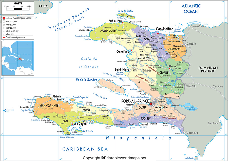
Why Use a Department Map of Haiti?
A departmental map can help students and researchers:
- Locate Haiti’s 10 departments
- Compare the country’s administrative regions
- Identify major towns and cities
- Understand Haiti’s regional geography
- Study departmental boundaries
- Prepare geography assignments and presentations
- Use a printable reference map for classroom activities
The country’s mountainous terrain is an important part of its geography. Haiti’s landscape includes several mountain ranges, coastal plains, valleys, and islands. A United Nations geographic reference describes the country’s rugged terrain and identifies major mountain systems and the Central Plateau.
Labeled Map of Haiti with States
Haiti Map with Cities Labeled
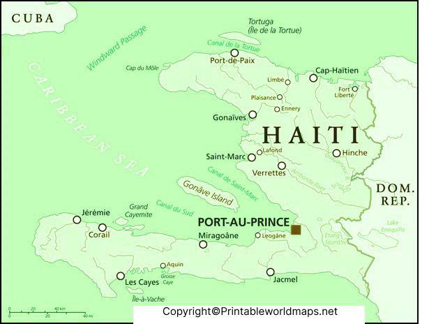
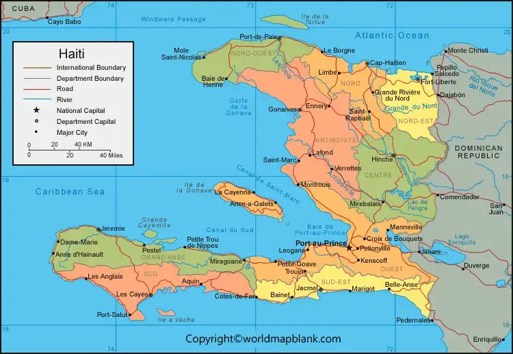
A Haiti map with cities labeled helps users locate major urban centres and other important places.
Some of the major cities and urban areas commonly shown on maps of Haiti include:
- Port-au-Prince
- Cap-Haïtien
- Gonaïves
- Les Cayes
- Jacmel
- Jérémie
- Hinche
- Port-de-Paix
- Pétion-Ville
- Carrefour
- Delmas
Port-au-Prince is the national capital and is located in the Ouest Department.
A city map can be particularly useful for students learning the locations of Haitian cities and for readers who want a visual overview of the country’s urban geography.
Labeled Map of Haiti with Capital
The capital of Haiti is Port-au-Prince.
Our labeled map of Haiti with capital highlights Port-au-Prince and provides a simple way to understand its location within the country.
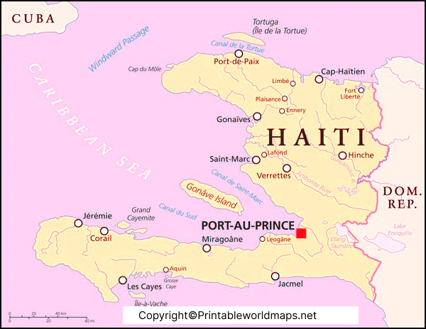
Port-au-Prince is located in the Ouest Department on the Gulf of Gonâve. The city is an important political, economic, and population centre of Haiti.
For a broader geographic reference, the United Nations map of Haiti identifies Port-au-Prince along with departmental boundaries, major towns, roads, coastlines, and surrounding geographic features.
Geography of Haiti
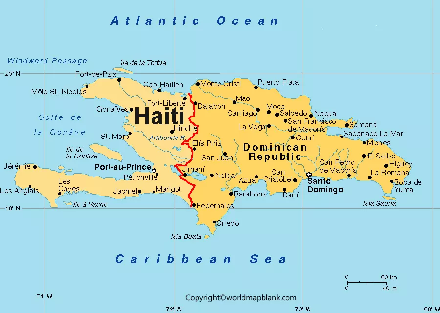
Haiti occupies the western part of the island of Hispaniola, which it shares with the Dominican Republic.
The country’s geography includes:
- Mountain ranges
- Coastal plains
- Valleys and plateaus
- The Gulf of Gonâve
- Several offshore islands
- Caribbean Sea coastline
- Major urban centres
- Departmental boundaries
Haiti’s highest mountain is Pic la Selle, located in the Massif de la Selle. UN geographic material describes Haiti as a predominantly mountainous country and identifies Mount La Selle as reaching approximately 2,674 metres.
The country’s physical geography makes a detailed map particularly useful for understanding the relationship between mountains, plains, coastal areas, cities, and administrative regions.
Haiti Map for Students and Teachers
A labeled map of Haiti can be useful in geography and social studies lessons.
Teachers can use these maps for:
- Geography worksheets
- Classroom presentations
- Map-labeling exercises
- Country research projects
- Department identification activities
- Caribbean geography lessons
- Printable homework resources
Students can use the maps to practice identifying Haiti’s capital, departments, cities, surrounding waters, and major physical features.
Printable Map of Haiti PDF
Printable PDF versions are provided for users who want to save or print the maps.
PDF maps are useful when you need:
- A classroom handout
- A geography worksheet
- A printable country reference
- A study resource
- An offline map
- A high-quality document for printing
Use the PDF links provided below each map to access the corresponding printable version.
Haiti Map: Key Facts
Here are several useful facts to keep with the map:
| Fact | Information |
|---|---|
| Country | Haiti |
| Region | Caribbean |
| Island | Hispaniola |
| Capital | Port-au-Prince |
| Administrative divisions | 10 departments |
| Area | 27,750 km² |
| Currency | Haitian gourde (HTG) |
| Official languages | Haitian Creole and French |
| Highest mountain | Pic la Selle |
| Main surrounding waters | Caribbean Sea and Atlantic Ocean |
UN data lists Haiti’s surface area at 27,750 km², its capital as Port-au-Prince, and its currency as the Haitian gourde.
Haiti Population and Current Data
For current demographic and economic information, it is better to use regularly updated statistical sources rather than relying on an old map page.
The World Bank’s latest available data lists Haiti’s 2025 population at approximately 11.91 million. Its 2025 data also reports GDP of approximately US$32.08 billion and annual GDP growth of -2.7%.
Because population and economic indicators change over time, readers should check the latest World Bank or United Nations data when using these figures for research.
Interesting Facts About Haiti
Haiti became independent in 1804.
Haiti shares the island of Hispaniola with the Dominican Republic.
Port-au-Prince is the capital of Haiti.
Haiti has 10 departments.
Haiti is located in the Caribbean region.
The country has a mountainous landscape with several major ranges.
Pic la Selle is Haiti’s highest mountain.
The Gulf of Gonâve is an important geographic feature along Haiti’s western coast.
Haiti includes several islands in addition to its mainland territory.
Haitian Creole and French are the country’s official languages.
How to Use the Labeled Map of Haiti
You can use the maps on this page for several purposes:
For students: Identify the capital, departments, cities, and physical features.
For teachers: Download the printable PDF and use it for classroom activities or geography worksheets.
For researchers: Use the map as a visual geographic reference alongside authoritative statistical and geographic sources.
For general readers: Explore Haiti’s location, major cities, departments, and physical geography.
Frequently Asked Questions About the Labeled Map of Haiti
How many departments does Haiti have?
Haiti has 10 departments: Artibonite, Centre, Grand’Anse, Nippes, Nord, Nord-Est, Nord-Ouest, Ouest, Sud, and Sud-Est.
What is the capital of Haiti?
The capital of Haiti is Port-au-Prince.
Is Haiti divided into states?
No. Haiti’s first-level administrative divisions are called departments, not states.
What island is Haiti located on?
Haiti occupies the western portion of Hispaniola, an island it shares with the Dominican Republic.
What is the largest city in Haiti?
Port-au-Prince is the country’s capital and its principal urban centre.
What is the highest mountain in Haiti?
Pic la Selle is Haiti’s highest mountain, with an elevation of approximately 2,674 metres according to UN geographic material.
Can I print the Haiti map?
Yes. The printable PDF versions provided with the maps can be downloaded and printed for personal, educational, or reference use, subject to the site’s applicable usage terms.
Who can use a labeled map of Haiti?
Students, teachers, researchers, travelers, geography enthusiasts, and anyone looking for a visual reference of Haiti can use a labeled map.
Reference Links
United Nations Haiti Country Data:
https://data.un.org/legacy/en/iso/ht.html
United Nations Haiti Country Profile:
https://data.un.org/CountryProfile.aspx?crName=Haiti
United Nations Geospatial Haiti Map:
https://haiti.un.org/sites/default/files/2023-12/Results%20Report%202022%20-%20Final.pdf
World Bank Haiti Data:
https://data.worldbank.org/country/haiti
World Bank Haiti Country Overview:
https://www.worldbank.org/ext/en/country/haiti
UN Digital Library — Haiti Geographic Information:
https://digitallibrary.un.org/record/4025757/files/Americas%20Book.pdf
CIA World Factbook — Map References:
https://www.cia.gov/the-world-factbook/about/archives/2024/field/map-references/









