

Discover all the available mountains of Africa with our map of Antarctica mountains easily and plan your visit to the content accordingly. We are here going to provide the physical geographical template of Antarctica template for the ease of our readers.
- World coronavirus map
- World geographical map
- World Map Wallpaper
- World population map
- Accurate Map of the World
- Ancient World map
Antarctica Mountains Map
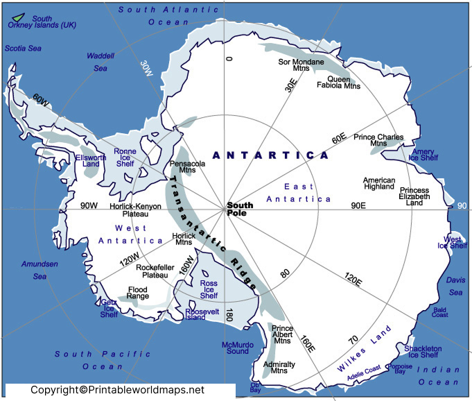
The Antarctica Mountains Map shows the major mountain systems and notable peaks across the world’s southernmost continent. Although Antarctica is largely covered by a vast ice sheet, its landscape includes extensive mountain ranges, isolated peaks, volcanic mountains, nunataks, and mountain systems partly hidden beneath the ice.
Antarctica is the coldest, driest, windiest, and highest continent on Earth by average elevation. The British Antarctic Survey reports that Antarctica covers about 13.94 million km², while only around 0.33% of its surface is ice-free. The Antarctic ice sheet can reach several kilometres in thickness, meaning many geological features are hidden beneath the ice.
This Antarctica mountain map provides a useful geographical reference for students, teachers, researchers, map enthusiasts, and anyone interested in Antarctic geography.
Map of Antarctica Mountains
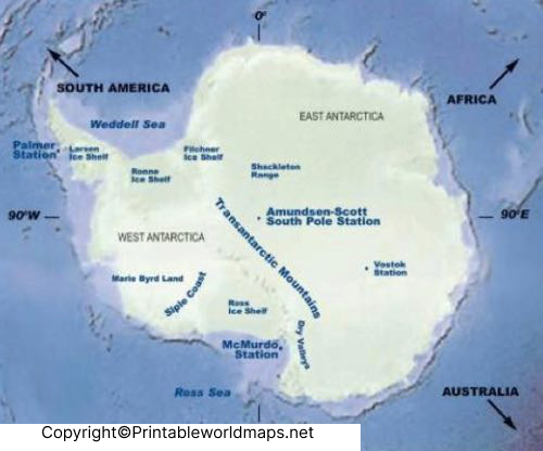
The mountains of Antarctica are distributed across several major geographical regions. Some of the most important mountain systems include the Transantarctic Mountains, Ellsworth Mountains, Antarctic Peninsula mountain ranges, and numerous ranges and isolated peaks in East Antarctica.
The Transantarctic Mountains are among the continent’s most important geographical features. They extend for approximately 3,300 km and form a major divide between East Antarctica and West Antarctica.
The Ellsworth Mountains contain the highest mountains in Antarctica, including Mount Vinson. The Ellsworth Mountains are located in West Antarctica and are particularly significant for Antarctic exploration and mountaineering.
Major Antarctic Mountain Regions
| Mountain region | Location / significance |
|---|---|
| Ellsworth Mountains | Home to Mount Vinson, Antarctica’s highest mountain |
| Transantarctic Mountains | Approximately 3,300 km long; separates East and West Antarctica |
| Queen Alexandra Range | Part of the Transantarctic Mountains |
| Queen Elizabeth Range | Mountain range within the Transantarctic system |
| Antarctic Peninsula ranges | Mountainous region extending toward the tip of the peninsula |
| Sentinel Range | Major range within the Ellsworth Mountains |
| Heritage Range | Mountain system within the Ellsworth Mountains |
| Queen Maud Mountains | Major section of the Transantarctic Mountains |
Printable Antarctica Mountains Map Labeled
A printable Antarctica Mountains Map can be useful for geography lessons, classroom activities, research, presentations, and general reference.
When using a printable map, it is important to distinguish between mountain peaks, mountain ranges, ice-covered terrain, and subglacial topography. Antarctica’s visible surface does not reveal all of the continent’s underlying geography because most of the land is covered by ice.
For educational use, a labeled map can help users identify important mountain systems such as the Transantarctic Mountains and Ellsworth Mountains, as well as notable peaks such as Mount Vinson and Mount Erebus.
If you provide multiple map versions on the page, consider offering:
- Labeled Antarctica Mountains Map
- Blank Antarctica Mountains Map
- Printable Antarctica Mountains Map
- High-resolution Antarctica Mountains Map
- Antarctica physical map
- Antarctica mountain ranges map
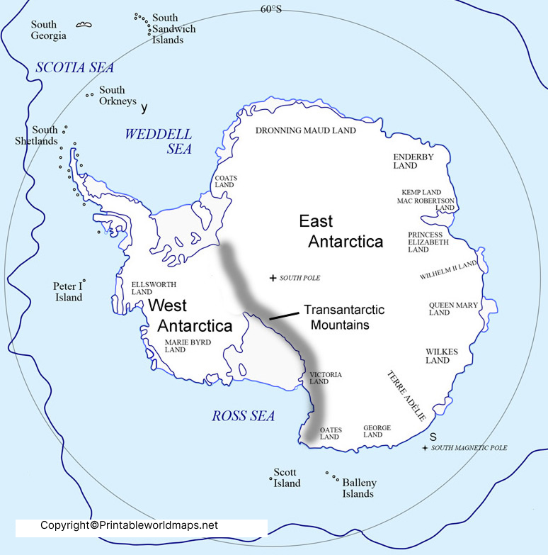
Highest Mountains in Antarctica
According to the British Antarctic Survey’s February 2026 Antarctic Factsheet, Mount Vinson is the highest mountain in Antarctica at 4,892 metres above sea level. The same source provides the following ranking of the highest Antarctic peaks.
| Rank | Mountain | Elevation | Mountain system |
|---|---|---|---|
| 1 | Mount Vinson | 4,892 m | Ellsworth Mountains |
| 2 | Mount Tyree | 4,852 m | Ellsworth Mountains |
| 3 | Mount Shinn | 4,661 m | Ellsworth Mountains |
| 4 | Mount Craddock | 4,650 m | Ellsworth Mountains |
| 5 | Mount Gardner | 4,587 m | Ellsworth Mountains |
| 6 | Mount Kirkpatrick | 4,528 m | Queen Alexandra Range |
| 7 | Mount Elizabeth | 4,480 m | Queen Alexandra Range |
| 8 | Mount Epperly | 4,359 m | Ellsworth Mountains |
| 9 | Mount Markham | 4,350 m | Queen Elizabeth Range |
| 10 | Mount Bell | 4,303 m | Queen Alexandra Range |
Elevations are based on the British Antarctic Survey’s 2026 geographical statistics; BAS notes that some mountain elevations are based on surveys of variable accuracy.
Mountains Map of Antarctica
Our readers can here check out the printable template of the Antarctica mountains map. This printable map template is useful to use as the full-fledged mountain map of the continent. You can easily print it from here and then use it to have a decent look at the Antarctica mountains. If you are a scholar then you can use it as the physical map of Antarctica for your learnings.
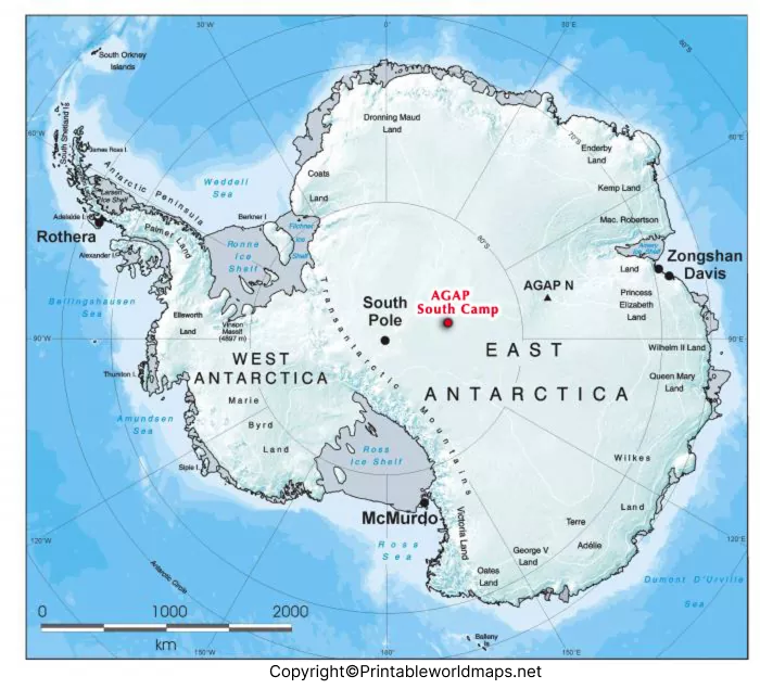
Furthermore, you can also use it for your tourist purpose if you are an explorer. Feel free to get both the printable and digital format of the template. We believe it would save you significant time and money with its decent availability and compatibility.
Mount Vinson – Highest Mountain in Antarctica
Mount Vinson is the highest mountain in Antarctica, reaching 4,892 metres (16,050 feet) above sea level. It is located in the Ellsworth Mountains of West Antarctica.
Mount Vinson is part of the Vinson Massif, one of the best-known mountain areas on the continent. Its extreme altitude, remote location, cold temperatures, and difficult logistics make climbing Mount Vinson a significant mountaineering challenge.
The British Antarctic Survey confirms that Mount Vinson remains the highest mountain in Antarctica.
Transantarctic Mountains
The Transantarctic Mountains are one of the most prominent mountain systems shown on an Antarctica Mountains Map.
They stretch for approximately 3,300 km across Antarctica and divide the continent into the broad regions of East Antarctica and West Antarctica.
The range includes several important mountain groups, including the Queen Alexandra Range, Queen Elizabeth Range, and Queen Maud Mountains.
The Transantarctic Mountains are also important to glaciology because they influence the movement and drainage of Antarctic ice.
Ellsworth Mountains
The Ellsworth Mountains are located in West Antarctica and contain Antarctica’s highest peaks.
The range includes two major sections commonly identified as the Sentinel Range and Heritage Range. Mount Vinson and several of Antarctica’s other highest peaks are located in this mountain system.
The concentration of very high peaks in the Ellsworth Mountains makes this one of the most important regions to identify on an Antarctica Mountains Map.
Antarctic Peninsula Mountains
The Antarctic Peninsula extends northward from the main Antarctic landmass toward South America and contains extensive mountainous terrain.
The region has numerous peaks exceeding 3,000 metres. Modern satellite mapping has also improved the accuracy of Antarctic mountain elevations.
For example, British Antarctic Survey mapping identified Mount Hope as the highest mountain in the British Antarctic Territory at 3,239 metres, replacing the previously mapped Mount Jackson as the highest in that territory.
This demonstrates why modern satellite-based mapping is important for accurately representing Antarctic geography.
Mount Erebus and Antarctic Volcanoes
Not all important Antarctic mountains are part of the continent’s major mountain ranges.
Mount Erebus, located on Ross Island, is a major Antarctic volcano and one of the world’s southernmost active volcanoes. It is also an important geographical landmark in the Ross Sea region.
Antarctica contains several volcanic features in addition to its extensive non-volcanic mountain ranges. The British Antarctic Survey identifies active volcanoes among Antarctica’s geological features.
Mountains Hidden Beneath Antarctica’s Ice
One of the most fascinating aspects of Antarctic geography is that not all mountains are visible at the surface.
Huge areas of the Antarctic bedrock are covered by ice. Scientists use aircraft surveys, satellites, radar measurements, and other geophysical techniques to reconstruct the landscape underneath the ice.
The Bedmap3 project, led by the British Antarctic Survey and published in 2025, combines more than six decades of survey information to produce a detailed picture of the landscape beneath Antarctica’s ice sheet.
The newer MEaSUREs BedMachine Antarctica Version 4, released through the National Snow and Ice Data Center in January 2026, provides updated information about Antarctic bed topography and bathymetry.
This means an Antarctica Mountains Map can represent more than just the mountains visible above the ice—it can also support understanding of the hidden geological landscape beneath the Antarctic Ice Sheet.
Why Are Mountains Important in Antarctica?
Antarctic mountains are important for several scientific and geographical reasons.
1. They influence ice movement
Mountain ranges can affect the pathways followed by glaciers and ice streams as ice moves toward the coast.
2. They divide major Antarctic regions
The Transantarctic Mountains form a major geographical boundary between East and West Antarctica.
3. They reveal geological history
Exposed rocks and mountain formations provide scientists with evidence about Antarctica’s geological past.
4. They affect climate and weather
Mountain topography influences wind patterns, snowfall, glacier flow, and local climatic conditions.
Modern radar and satellite observations allow scientists to map terrain beneath kilometres of ice.
Antarctica Mountains Map Facts
Here are some useful facts for students and geography enthusiasts:
- Antarctica covers approximately 13.94 million km², including ice shelves and islands.
- Antarctica’s average elevation, including ice shelves, is approximately 1,958 metres.
- The average elevation excluding ice shelves is approximately 2,194 metres.
- Mount Vinson is the highest mountain in Antarctica at 4,892 metres.
- The Transantarctic Mountains extend about 3,300 km.
- Only about 0.33% of Antarctica is ice-free according to the February 2026 BAS factsheet.
- The Antarctic Ice Sheet can reach several kilometres in thickness.
- The Transantarctic Mountains separate the major East and West Antarctic regions.
- Modern satellite and radar mapping has significantly improved knowledge of Antarctic terrain.
- Some Antarctic mountains and geological structures remain concealed beneath the ice sheet.
Antarctica Mountains Map for Students
The map can be particularly useful for geography and earth-science education.
Students can use an Antarctica Mountains Map to:
- Locate Mount Vinson.
- Identify the Ellsworth Mountains.
- Locate the Transantarctic Mountains.
- Compare East and West Antarctica.
- Study Antarctic elevation.
- Understand mountain and glacier relationships.
- Learn about Antarctic volcanic features.
- Identify major geographical regions.
- Practice map-reading skills.
- Study the relationship between ice sheets and underlying terrain.
For teachers, a labeled and blank version can be particularly useful for classroom exercises and geography assignments.
Antarctica Mountain Mapping and Modern Technology
Mapping Antarctica is considerably more difficult than mapping most populated continents because much of the terrain is covered by thick ice and the environment is extremely remote.
Scientists therefore use a combination of:
- Satellite imagery
- Radar sounding
- Digital elevation models
- Airborne surveys
- GPS measurements
- Ice-penetrating radar
- Historical surveying
- Remote sensing
The NSIDC’s Antarctic digital elevation datasets incorporate satellite-derived elevation information, while newer datasets such as BedMachine Antarctica provide information about the bedrock and subglacial landscape.
The development of Bedmap3 is particularly significant because it combines decades of observations to improve understanding of the landscape beneath Antarctica’s ice.
How to Use an Antarctica Mountains Map
An Antarctica Mountains Map can be used for both educational and research-oriented purposes.
For students: use the map to identify mountain ranges and important peaks.
For teachers: use a labeled map for explanation and a blank map for quizzes or assignments.
For researchers: use authoritative elevation and topographic datasets rather than relying solely on simplified educational maps.
For travelers and mountaineers: use specialist Antarctic expedition and safety information in addition to general geographical maps. A general map should not be treated as a navigation or expedition-safety resource.
Frequently Asked Questions About Antarctica Mountains
What is the highest mountain in Antarctica?
Mount Vinson is the highest mountain in Antarctica. Its elevation is 4,892 metres (16,050 feet) above sea level according to the British Antarctic Survey’s 2026 geographical statistics.
Where are the highest mountains in Antarctica?
Most of Antarctica’s highest peaks are concentrated in the Ellsworth Mountains in West Antarctica. Mount Vinson, Mount Tyree, Mount Shinn, and several other high peaks are located there.
What is the largest mountain range in Antarctica?
The Transantarctic Mountains are one of Antarctica’s largest and most significant mountain systems, extending approximately 3,300 km across the continent.
Does Antarctica have mountains?
Yes. Antarctica contains extensive mountain ranges, individual peaks, volcanic mountains, and mountain systems hidden beneath the ice sheet.
What are the major mountain ranges in Antarctica?
Important mountain systems include the Transantarctic Mountains, Ellsworth Mountains, Sentinel Range, Heritage Range, Queen Alexandra Range, Queen Elizabeth Range, and mountain ranges of the Antarctic Peninsula.
Is Mount Everest higher than Mount Vinson?
Yes. Mount Everest is higher above sea level than Mount Vinson. Mount Vinson’s elevation is 4,892 metres, while Mount Everest is approximately 8,849 metres above sea level.
Is Mount Vinson an active volcano?
No. Mount Vinson is a high mountain in the Ellsworth Mountains, not an active volcano. Antarctica does, however, contain active volcanic features, including Mount Erebus.
Are there mountains underneath the Antarctic ice?
Yes. Large areas of Antarctic bedrock and mountain terrain are concealed beneath the ice sheet. Modern radar and satellite-based datasets are used to reconstruct this hidden landscape.
What separates East and West Antarctica?
The Transantarctic Mountains form a major geographical division between East Antarctica and West Antarctica.
A general educational map should not be used as the sole source for navigation or expedition planning. Antarctic travel requires current specialist maps, route information, weather information, and professional safety guidance.
Sources and Reference Links
- British Antarctic Survey – Antarctic Factsheet: Antarctic Factsheet
- British Antarctic Survey – 2026 Geographical Statistics: Antarctic Factsheet 2026 PDF
- British Antarctic Survey – Antarctica: Antarctica Geography and Geology
- British Antarctic Survey – Antarctic Mountain Mapping: New Satellite Mapping of Antarctic Mountains
- British Antarctic Survey – Bedmap3: Bedmap3: Mapping the Landscape Beneath Antarctica
- NSIDC – Why Ice Sheets Matter: National Snow and Ice Data Center – Antarctica Ice Sheets
- NSIDC – BedMachine Antarctica: MEaSUREs BedMachine Antarctica Version 4
- NSIDC – Antarctic Digital Elevation Model: Antarctic Digital Elevation Model
