

A labeled map of Syria helps readers identify the country’s capital, major cities, administrative divisions, neighboring countries, and important geographical features. This collection includes printable maps of Syria with city labels, governorate boundaries, and the capital marked for easy reference.
Syria, officially known as the Syrian Arab Republic, is located in Western Asia along the eastern coast of the Mediterranean Sea. Its geography includes a Mediterranean coastline, mountain ranges, fertile agricultural areas, river valleys, and extensive dry regions. Damascus is the country’s capital, while Aleppo, Homs, Hama, Latakia, and Deir ez-Zor are among its other notable cities.
Syria is administratively divided into 14 governorates, rather than states. The maps below can help students, teachers, researchers, and geography enthusiasts understand the country’s administrative and physical geography.
- World coronavirus map
- World geographical map
- World population map
- Accurate map of World
- Ancient World map
- World Map Wallpaper
Labeled Map of Syria
A labeled map of Syria displays geographical names directly on the map, making it easier to identify important locations without constantly referring to a separate legend. Depending on the map, labels may show the country’s borders, major cities, administrative divisions, neighboring countries, and geographical features.
Use the following map to explore Syria’s overall geographical layout.
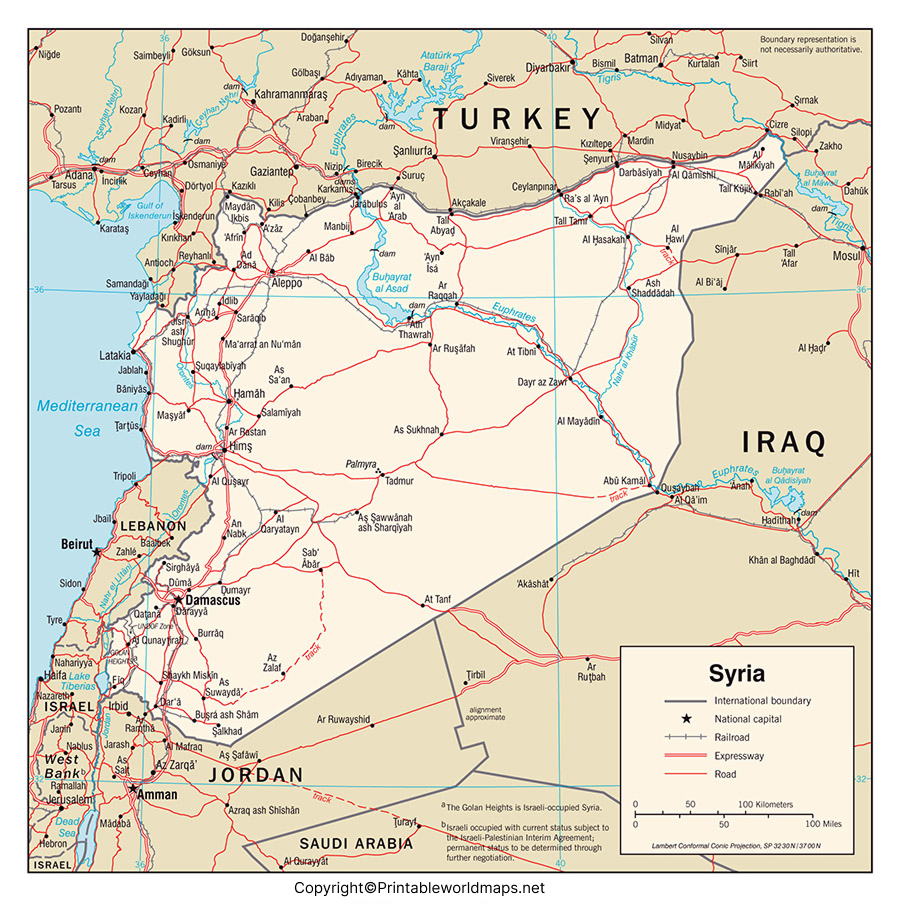
This map is useful for school assignments, geography lessons, country studies, and general reference. Before using it for detailed research, check which boundaries and place names are included in the particular map.
Labeled Map of Syria with States

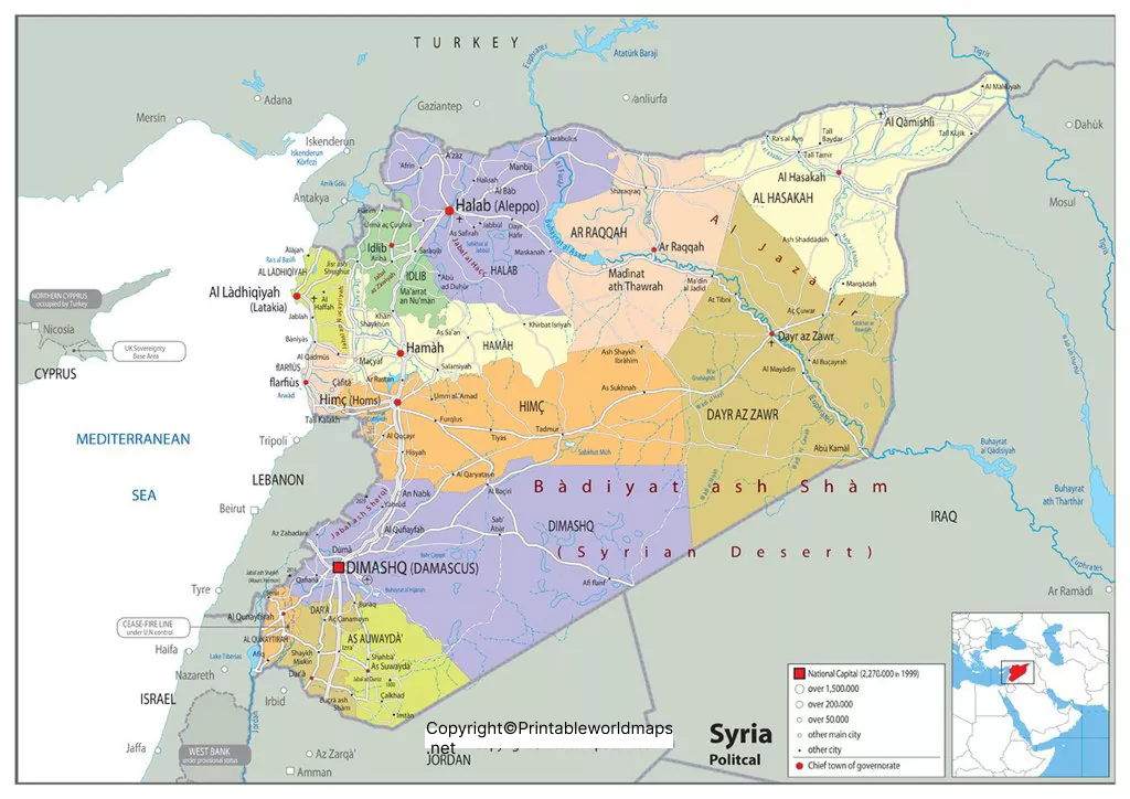
Syria does not use states as its main administrative divisions. Instead, the country is divided into 14 governorates, also known as muhafazat in Arabic. A governorate map helps readers understand the administrative organization of the country and locate major regions.
For accuracy, the term “governorates” is preferable to “states” when describing Syria’s administrative divisions. The original map heading may still use the word “states,” but readers should understand that it refers to governorates in this context.
The 14 governorates are Al-Hasakah, Aleppo, Ar-Raqqah, As-Suwayda, Damascus, Daraa, Deir ez-Zor, Hama, Homs, Idlib, Latakia, Quneitra, Rural Damascus, and Tartus. English spellings can vary between maps and reference sources.
Labeled Map of Syria with Cities
A labeled map of Syria with cities helps readers locate urban centers and understand their positions relative to one another. City maps are particularly useful for educational activities, regional comparisons, and introductory studies of Syrian geography.
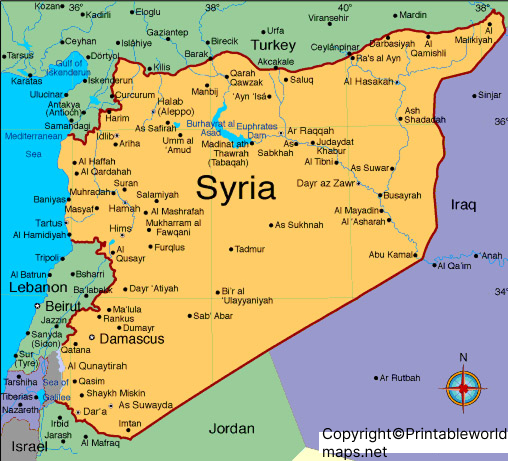
Some of Syria’s best-known cities include:
- Damascus: The national capital, located in southwestern Syria.
- Aleppo: A major city in northern Syria with a long history of trade and cultural exchange.
- Homs: An important city in western-central Syria.
- Hama: A city in western Syria known for its historic waterwheels along the Orontes River.
- Latakia: A coastal city on the Mediterranean Sea.
- Tartus: A coastal city and port in western Syria.
- Deir ez-Zor: A major urban center in eastern Syria, near the Euphrates River.
- Ar-Raqqah: A city in northern Syria, also associated with the Euphrates River.
City names and their spellings may differ between English-language maps. For detailed research, compare map labels with a reliable geographical reference.
Labeled Syria Map with Capital
Damascus is the capital of Syria and one of its most historically significant cities. A map highlighting the capital helps readers distinguish the national capital from other major urban centers and understand its location within the country.
Damascus is situated in southwestern Syria, in an area associated with the Barada River and an oasis environment. Its long history makes it an important location in studies of Middle Eastern geography, settlement, and cultural heritage.
When reading a capital map, look for the symbol or label used to distinguish Damascus from other cities. Some maps mark the capital with a star, while others use a larger dot or a different label style.
Geography Facts About Syria
These basic facts provide additional context for interpreting a labeled map of Syria.
- Official name: Syrian Arab Republic.
- Continent: Asia, specifically Western Asia.
- Capital: Damascus.
- Administrative divisions: 14 governorates.
- Coastline: Along the eastern Mediterranean Sea.
- Neighboring countries and territories: Turkey, Iraq, Jordan, Lebanon, and Israel; the status of some border areas is politically disputed.
- Major river: The Euphrates is one of Syria’s most important rivers.
- Geographical features: Coastal plains, mountain ranges, inland plateaus, river valleys, and arid regions.
Syria’s landscapes vary considerably from west to east. The coastal region is influenced by the Mediterranean, while inland and eastern areas include drier terrain. The Euphrates River is an important geographical feature that can help readers orient themselves on a physical map.
For additional verified information, consult the CIA World Factbook entry for Syria and the UN Humanitarian Atlas for Syria.
How to Use and Print These Maps
These maps can support classroom learning, personal study, presentations, and general geographical reference.
- Choose the map that best matches your needs, such as a city map, governorate map, or capital map.
- Open the PNG or JPG image to view it online.
- Use the PDF version when you need a printable document.
- Select landscape or portrait orientation according to the map’s proportions.
- Check the labels and source information before using the map in a formal report or publication.
For clearer printed labels, use a high-resolution file and select a suitable print size. Small labels may become difficult to read when the map is reduced to fit a page.
Map boundaries and place names can vary by publication date and source. For academic, humanitarian, or professional work, confirm administrative information with a current authoritative reference.
Frequently Asked Questions
1. What does a labeled map of Syria show?
A labeled map of Syria identifies geographical features and locations using names printed directly on the map. Depending on its design, it may show cities, the capital, governorate boundaries, neighboring countries, rivers, and other features.
2. What is the capital of Syria?
Damascus is the capital of Syria. It is located in the southwestern part of the country.
3. How many states does Syria have?
Syria has 14 governorates, not states. Governorates are the country’s principal administrative divisions.
4. Which are the major cities shown on a Syria map?
Commonly identified cities include Damascus, Aleppo, Homs, Hama, Latakia, Tartus, Deir ez-Zor, and Ar-Raqqah. The exact cities shown depend on the map.
5. Can I download a printable map of Syria in PDF format?
Yes. The PDF links in this article provide printable versions of the supplied maps. Open a link to view the file and use your browser’s download or print option if the file is accessible.
6. Which countries border Syria?
Syria borders Turkey, Iraq, Jordan, Lebanon, and Israel. Some boundaries and territorial questions in the region are politically disputed, so consult a current authoritative map for legal or official use.
7. What is the best map of Syria for students?
A labeled map showing the capital, major cities, and governorate boundaries is a useful starting point. A physical map can provide additional information about mountains, rivers, plains, and other landforms.
8. Why is Damascus important on a map of Syria?
Damascus is the national capital and a major historical urban center. Marking it on a map helps readers identify the country’s capital in relation to other cities and administrative regions.
Reference links
https://www.cia.gov/the-world-factbook/countries/syria
https://humanitarianatlas.org/syria
