

West Virginia is a mountainous state in the eastern United States. This Labeled Map of West Virginia makes it easier to identify the state capital, major cities, counties, rivers, neighboring states, and other important geographic features.
West Virginia is bordered by Ohio, Kentucky, Virginia, Maryland, and Pennsylvania. The state is known for its Appalachian Mountain landscape and is commonly called the Mountain State.
A labeled map is useful for students, teachers, researchers, travelers, and anyone who needs a clear geographic reference for West Virginia.
Labeled Map of West Virginia
The Labeled Map of West Virginia shows important geographic locations across the state, including Charleston, Huntington, Morgantown, Parkersburg, Wheeling, and other populated places.
The map can also help users understand the relationship between West Virginia’s cities, surrounding states, major waterways, and transportation routes.
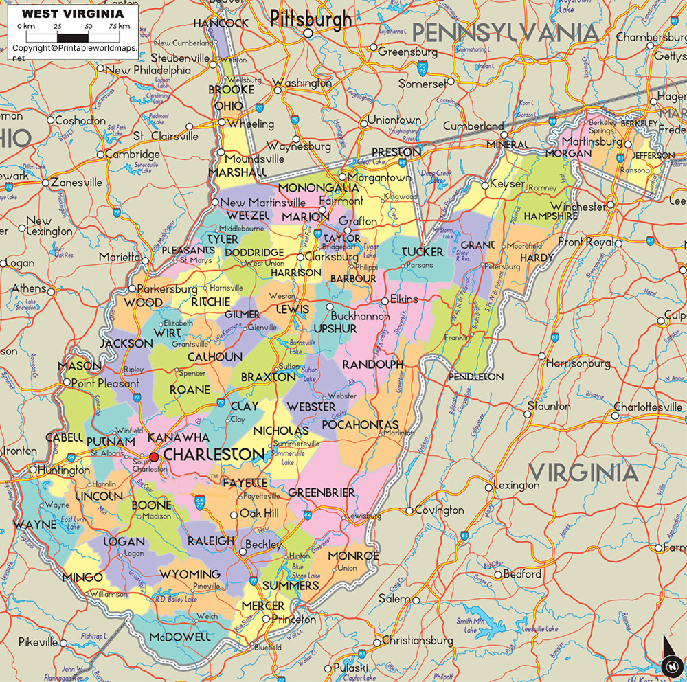
West Virginia Map Facts
According to U.S. Census Bureau data, West Virginia has approximately 24,041.3 square miles of land area and 188.7 square miles of water area. It ranks as the 40th-largest U.S. state by area.
The 2020 Census recorded a population of 1,793,716. The Census Bureau’s July 1, 2025 population estimate is 1,766,147.
West Virginia has 55 counties, making a county map particularly useful for understanding the state’s administrative geography.
Labeled Map of West Virginia Printable
A printable Labeled Map of West Virginia is useful for classroom assignments, geography lessons, state studies, presentations, and personal reference.
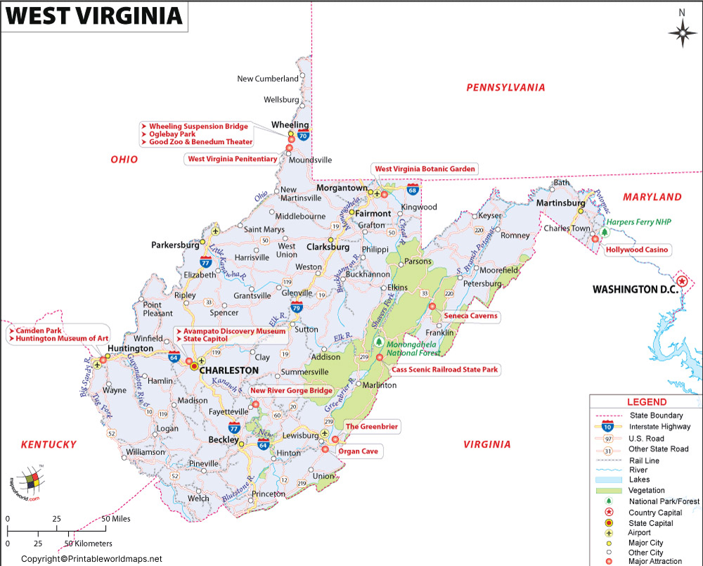
West Virginia has 55 counties. The state’s county structure provides a useful way to organize geographic information and locate communities throughout the Mountain State.
Labeled Map of West Virginia with Cities
The Labeled Map of West Virginia with Cities helps users locate major population centers and understand their geographic distribution.
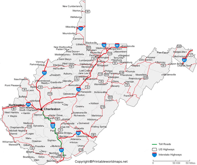
Some of the state’s notable cities include Charleston, Huntington, Morgantown, Parkersburg, Wheeling, Martinsburg, Fairmont, Beckley, Clarksburg, and Bluefield.
USGS geographic research identifies Charleston, Huntington, Parkersburg, Wheeling, and Morgantown among West Virginia’s larger cities and population centers.
Labeled West Virginia Map with Capital
The Labeled West Virginia Map with Capital identifies Charleston, the state capital.
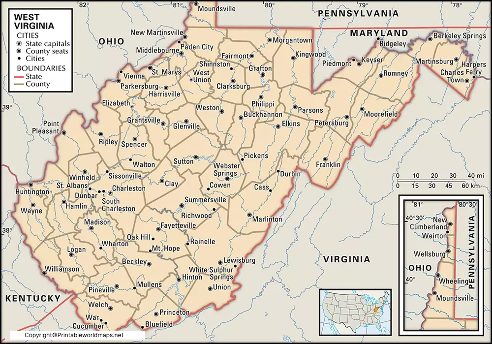
Charleston is located along the Kanawha River in Kanawha County. The Kanawha River is an important part of West Virginia’s geography and joins the Ohio River near Point Pleasant. USGS research describes the Kanawha-New River system as an important drainage network spanning West Virginia, Virginia, and North Carolina.
West Virginia Rivers and Waterways
West Virginia’s mountainous landscape is closely connected to its rivers and watersheds.
Important rivers associated with the state include:
- Ohio River
- Kanawha River
- New River
- Gauley River
- Monongahela River
- Little Kanawha River
- Greenbrier River
- Elk River
- Guyandotte River
The New River flows northward through North Carolina, Virginia, and West Virginia before joining the Gauley River to form the Kanawha River. The Kanawha then flows toward the Ohio River.
The USGS also identifies the Kanawha-New River basin as a mountainous watershed containing portions of three physiographic regions: the Blue Ridge, Valley and Ridge, and Appalachian Plateaus.
West Virginia Geography
West Virginia is strongly associated with the Appalachian Mountains. Much of the state consists of hills, ridges, valleys, plateaus, and river corridors.
The state’s terrain varies considerably by region. The Eastern Panhandle contains long ridges and valleys, while central and southern portions include extensive mountainous terrain. USGS research also documents elevations exceeding 4,000 feet in parts of the state.
This geographic variation makes a labeled state map particularly helpful when studying West Virginia’s physical geography.
Why Use a Labeled Map of West Virginia?
A labeled map can be useful for:
- Students: Learn cities, counties, rivers, and state geography.
- Teachers: Prepare geography worksheets and classroom activities.
- Researchers: Quickly reference locations and regional relationships.
- Travelers: Understand the locations of major cities and geographic areas.
- Presentations: Use a visual reference when explaining West Virginia geography.
- Homeschooling: Support state and U.S. geography lessons.
- Map study: Compare physical and political features of the state.
Interesting Facts About West Virginia
- West Virginia is known as the Mountain State.
- Charleston is the state capital.
- West Virginia has 55 counties.
- The state borders five states: Ohio, Kentucky, Virginia, Maryland, and Pennsylvania.
- The 2020 Census recorded a population of 1,793,716.
- The New River and Kanawha River are important parts of the state’s river system.
- West Virginia contains portions of several Appalachian physiographic regions.
Frequently Asked Questions
What is the capital of West Virginia?
Charleston is the capital of West Virginia. It is located in Kanawha County along the Kanawha River.
How many counties are in West Virginia?
West Virginia has 55 counties.
What states border West Virginia?
West Virginia shares borders with Ohio, Kentucky, Virginia, Maryland, and Pennsylvania.
What is the largest city in West Virginia?
Charleston is the state capital, while Huntington is one of the state’s major cities. City population rankings can vary depending on the Census dataset and reference year, so current Census data should be used when comparing city populations.
What rivers are shown on a West Virginia map?
Important waterways associated with West Virginia include the Ohio, Kanawha, New, Gauley, Monongahela, Little Kanawha, Greenbrier, Elk, and Guyandotte rivers.
Where can I download a printable West Virginia map?
Printable PNG and PDF versions are provided above. They can be used for educational, reference, and map-study purposes.
Why is West Virginia called the Mountain State?
West Virginia’s landscape is dominated by Appalachian mountain terrain, including ridges, valleys, plateaus, and mountainous areas.
What is the population of West Virginia?
The 2020 U.S. Census counted 1,793,716 people in West Virginia. The Census Bureau estimated the population at 1,766,147 on July 1, 2025.
Reference Links
https://data.census.gov/profile/West_Virginia?g=0400000US54
https://www.census.gov/quickfacts/fact/csv/WV/LND110210
