

The Labeled Map of Vermont helps you locate the state’s capital, cities, counties, major rivers, lakes, highways, and surrounding states. Vermont is one of the six New England states and is located in the northeastern United States.
Vermont shares its northern border with Quebec, Canada, while New York lies to the west, New Hampshire to the east, and Massachusetts to the south. Montpelier is the state capital, while Burlington is the state’s largest city by population.
Vermont became an independent republic in 1777 and joined the United States as the 14th state on March 4, 1791.
Labeled Map of Vermont
The Labeled Map of Vermont shows important geographic features and locations throughout the state, including the state capital, cities, towns, major waterways, highways, and county boundaries.
Vermont covers approximately 9,616 square miles (24,923 square kilometers) of land and water area. It is the 45th-largest U.S. state by total area.
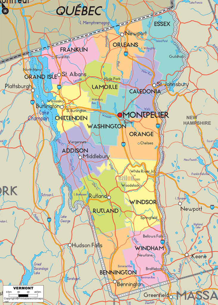
Labeled Map of Vermont Printable
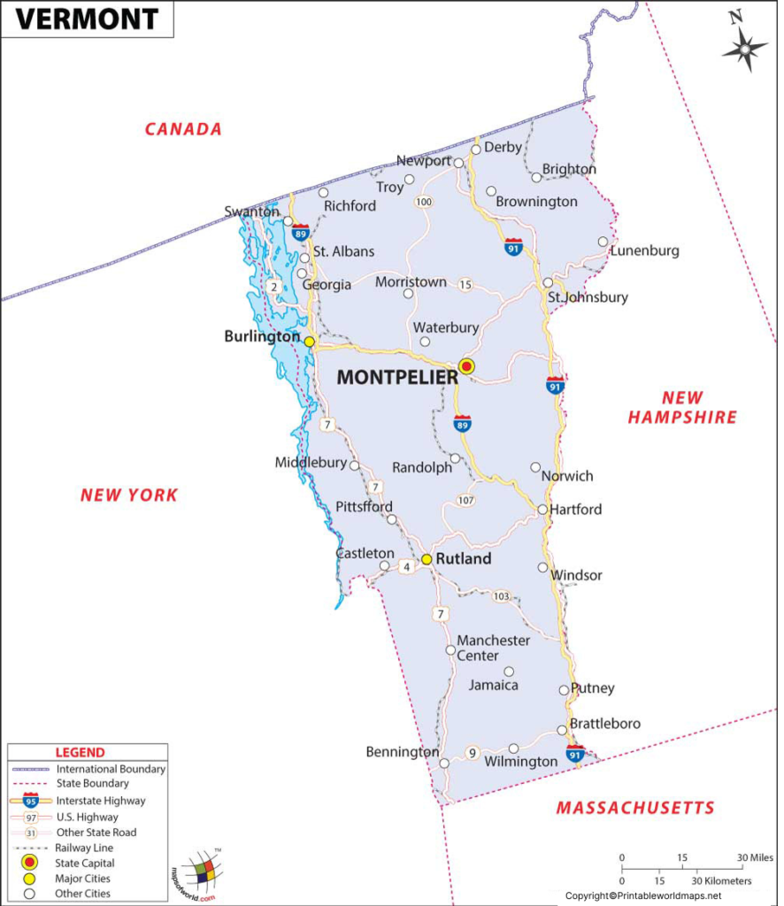
The Labeled Map of Vermont Printable is useful for students, teachers, researchers, travelers, and anyone studying Vermont geography.
The printable map can help identify Vermont’s location within New England, its neighboring states, major cities, counties, rivers, and other geographic features.
Vermont has 14 counties and numerous incorporated municipalities, including cities, towns, and villages.
Labeled Map of Vermont with Cities
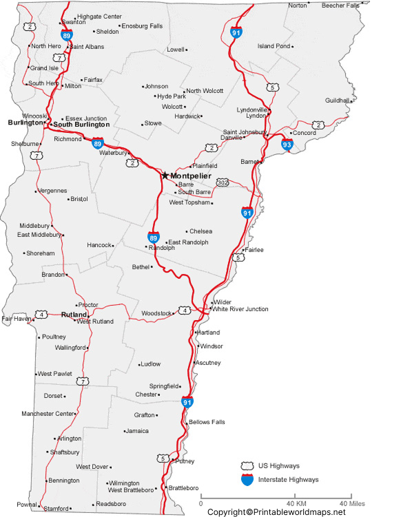
The Labeled Map of Vermont with Cities identifies important population centers throughout the state.
Some of Vermont’s notable cities and population centers include:
- Burlington
- South Burlington
- Rutland
- Barre
- Montpelier
- Winooski
- St. Albans
- Newport
- Vergennes
- Middlebury
Population figures should be taken from the latest U.S. Census Bureau estimates rather than the older 2016 figures previously used on this page.
Labeled Vermont Map with Capital
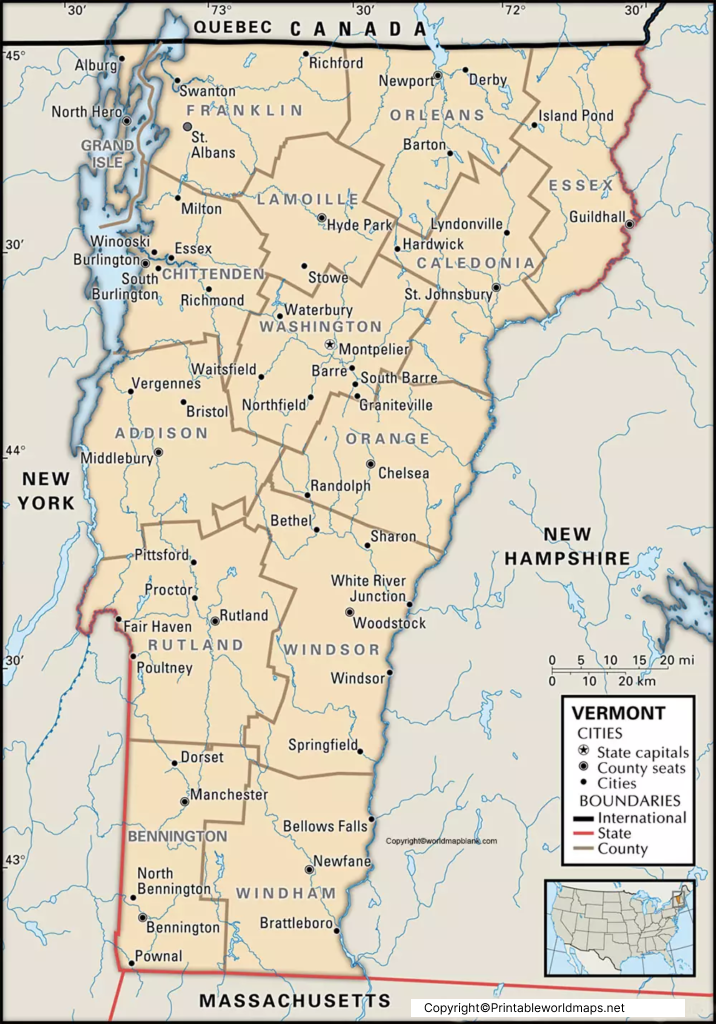
The Labeled Vermont Map with Capital highlights Montpelier, the capital city of Vermont.
Montpelier is located in Washington County along the Winooski River. It is notable for being the smallest U.S. state capital by population.
The Vermont State House is located in Montpelier and is recognized for its distinctive gold-colored dome. Other notable locations in the city include Hubbard Park and the Vermont Historical Society Museum.
Vermont Geography and Location
Vermont is located in the northeastern United States within the New England region.
Its borders are:
| Direction | Neighbor |
|---|---|
| North | Quebec, Canada |
| East | New Hampshire |
| West | New York |
| South | Massachusetts |
Lake Champlain is one of Vermont’s most prominent geographic features and forms part of the state’s western landscape. The Connecticut River forms much of the eastern boundary between Vermont and New Hampshire.
Vermont Counties
Vermont is divided into 14 counties:
- Addison County
- Bennington County
- Caledonia County
- Chittenden County
- Essex County
- Franklin County
- Grand Isle County
- Lamoille County
- Orange County
- Orleans County
- Rutland County
- Washington County
- Windham County
- Windsor County
A labeled county map can make it easier to understand Vermont’s administrative geography and the locations of its major communities.
Major Rivers and Lakes in Vermont
The map of Vermont can also help users identify important waterways.
Major waterways include:
- Connecticut River
- Winooski River
- Otter Creek
- Missisquoi River
- Lamoille River
- Lake Champlain
- Lake Memphremagog
Lake Champlain is particularly significant because it extends along Vermont’s western side and continues north into Quebec.
Interesting Facts About Vermont
- Vermont became the 14th state of the United States in 1791.
- Montpelier is Vermont’s state capital.
- Burlington is the state’s largest city by population.
- Vermont is part of the New England region.
- Vermont borders Canada to the north.
- Lake Champlain is one of the state’s most prominent natural features.
- Vermont is widely associated with the Green Mountains, which run through much of the state.
- The state is known for its maple syrup production, forests, and mountain landscapes.
Why Use a Labeled Map of Vermont?
A Labeled Map of Vermont can be useful for several purposes:
Education
Students can use labeled maps to learn Vermont’s cities, counties, waterways, and neighboring states.
Travel Planning
Travelers can identify major communities, highways, geographic regions, and attractions before visiting Vermont.
Research
Researchers can use maps to understand the state’s geographic and administrative organization.
Printing and Projects
Printable Vermont maps can be useful for classroom assignments, presentations, worksheets, and geography projects.
frequently asked questions
What is the capital of Vermont?
Montpelier is the capital of Vermont.
What does a labeled map of Vermont show?
A labeled map can show Vermont’s capital, cities, counties, rivers, lakes, highways, neighboring states, and other geographic features.
How many counties are in Vermont?
Vermont has 14 counties.
What states border Vermont?
Vermont borders New York, New Hampshire, and Massachusetts. It also shares an international border with Quebec, Canada.
What is the largest city in Vermont?
Burlington is Vermont’s largest city by population.
When did Vermont become a state?
Vermont became the 14th U.S. state on March 4, 1791.
What is Vermont known for?
Vermont is known for the Green Mountains, maple syrup, forests, Lake Champlain, and its New England landscape.
Where is Montpelier located?
Montpelier is located in Washington County in central Vermont.
Can I print a Vermont map?
Yes. Printable Vermont maps can be used for education, geography projects, travel planning, and reference purposes.
What is the main lake in Vermont?
Lake Champlain is the state’s most prominent lake and is located along Vermont’s western border.
Reference Links
https://www.census.gov/quickfacts/fact/table/VT/PST045225
