

The Labeled Map of Washington helps identify the state’s location, capital, major cities, counties, rivers, and surrounding geography. Washington is located in the Pacific Northwest of the United States. It borders Canada to the north, Idaho to the east, Oregon to the south, and the Pacific Ocean to the west.
Washington became the 42nd state of the United States on November 11, 1889. Its state capital is Olympia, while Seattle is the state’s largest city by population.
These labeled maps are useful for students, teachers, researchers, travelers, and anyone who needs a clear geographical reference for Washington.
Labeled Map of Washington
A labeled map makes it easier to identify Washington’s major geographic features and understand its position in the Pacific Northwest.
Washington shares its northern boundary with the Canadian province of British Columbia. Idaho lies to the east, Oregon borders the state to the south, and the Pacific Ocean forms much of the western boundary.
The Columbia River is an important geographic feature along parts of the Washington–Oregon border. Other significant rivers include the Snake River, Yakima River, Spokane River, Skagit River, and Okanogan River.
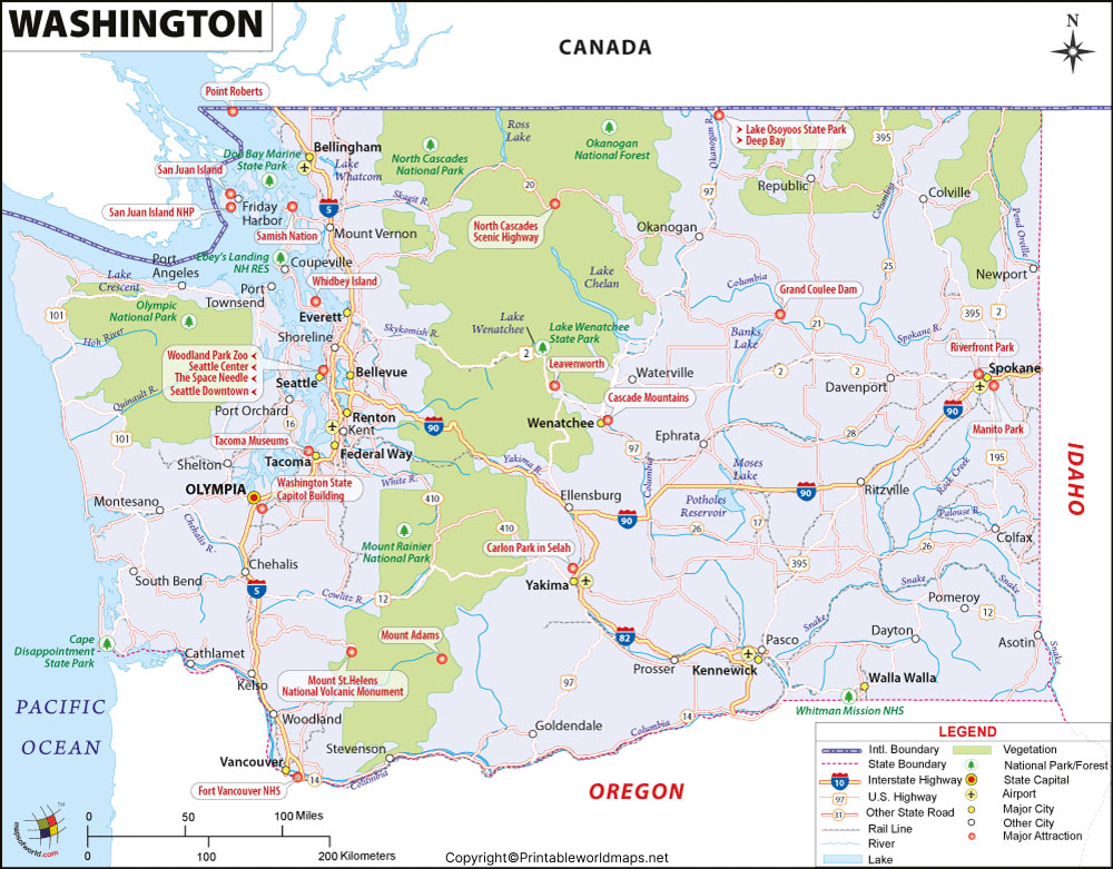
Washington covers approximately 66,455 square miles of land area, according to U.S. Census Bureau data. The state has 39 counties and includes diverse geographic regions ranging from the Pacific coastline and Puget Sound to the Cascade Range and inland areas.
Labeled Map of Washington Printable
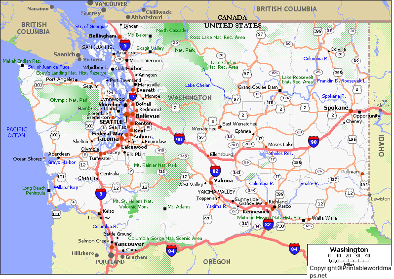
A Labeled Map of Washington Printable is useful when you need a physical reference for classroom activities, geography assignments, presentations, or personal study.
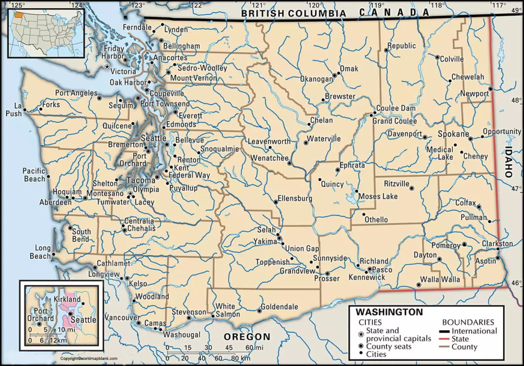
The state is divided into 39 counties. A county map can help users locate county boundaries and understand how Washington is organized administratively.
Washington’s counties vary considerably in size, geography, population, and land use. Okanogan County, for example, is located in the north-central part of the state and extends to the Canadian border.
For educational use, a printable labeled map can be combined with a blank map worksheet so students can practice identifying counties, cities, rivers, and other geographic features.
Labeled Map of Washington with Cities
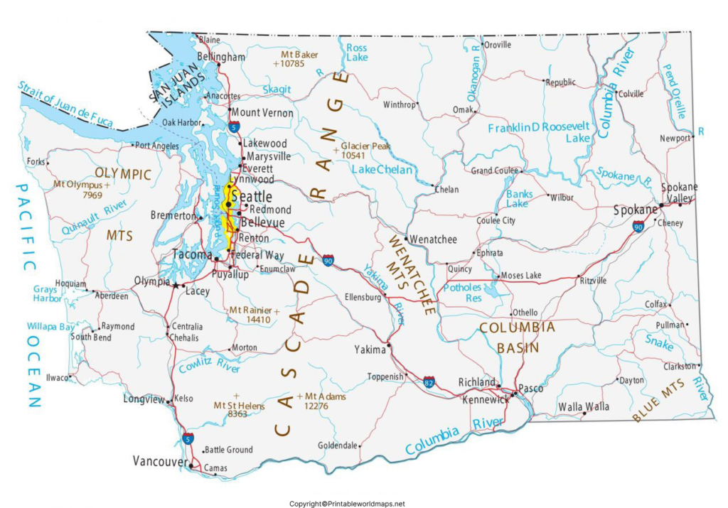
The Labeled Map of Washington with Cities identifies important population centers across the state.
Major Washington cities include:
- Seattle
- Spokane
- Tacoma
- Vancouver
- Bellevue
- Kent
- Everett
- Spokane Valley
- Renton
- Federal Way
Seattle is the state’s largest city by population. Spokane is a major population center in eastern Washington, while Tacoma, Bellevue, Everett, Vancouver, and other cities are important parts of the state’s urban and economic geography.
City populations change over time, so current population figures should be checked against the latest U.S. Census Bureau or Washington State Office of Financial Management data.
Labeled Map of Washington with Capital
The Labeled Map of Washington with Capital highlights Olympia, the capital of Washington state.
Olympia is located in Thurston County at the southern end of Puget Sound. It has served as Washington’s state capital since statehood.
A capital map is particularly useful for students learning about U.S. states and capitals because it shows the location of Olympia in relation to Seattle, Tacoma, other cities, and the state’s surrounding geography.
Washington Map Facts
Here are some useful facts to remember when studying the Labeled Map of Washington:
- State: Washington
- Region: Pacific Northwest
- Capital: Olympia
- Largest city: Seattle
- Statehood: November 11, 1889
- Statehood number: 42nd state
- Counties: 39
- Northern neighbor: British Columbia, Canada
- Eastern neighbor: Idaho
- Southern neighbor: Oregon
- Western boundary: Pacific Ocean
- Important rivers: Columbia, Snake, Yakima, Spokane, Skagit, and Okanogan
- Land area: approximately 66,455 square miles
According to the Washington State Office of Financial Management, the state’s estimated population reached 8,176,300 on April 1, 2026. Population figures can change annually, so current official estimates are preferable to older figures.
Why Use a Labeled Map of Washington?
A labeled map provides an easy visual reference for understanding the state’s geography.
It can be useful for:
- Geography lessons and school projects
- Identifying Washington’s capital and major cities
- Studying county boundaries
- Understanding neighboring states and Canada
- Locating major rivers and geographic features
- Planning educational presentations
- Printing classroom worksheets
- Comparing different regions of Washington
For students, combining a labeled map with a blank Washington map can make geography practice more interactive.
Interesting Facts About Washington
Washington has a varied landscape that includes the Pacific coastline, Puget Sound, the Cascade Range, forests, mountains, agricultural areas, and inland plateaus.
The state is also geographically distinctive because the Cascade Range divides much of western and eastern Washington. Western Washington is strongly influenced by the Pacific Ocean and Puget Sound, while eastern Washington contains extensive inland agricultural areas and a drier climate.
Washington’s geography is therefore more diverse than a simple state-boundary map might suggest.
Frequently Asked Questions
What is the capital of Washington?
The capital of Washington state is Olympia.
How many counties are in Washington?
Washington has 39 counties.
What is the largest city in Washington?
Seattle is the largest city in Washington by population.
When did Washington become a state?
Washington became the 42nd state on November 11, 1889.
What states border Washington?
Washington borders Oregon to the south and Idaho to the east. To the north, it borders British Columbia, Canada. The Pacific Ocean is to the west.
What are the major rivers shown on a Washington map?
Important rivers include the Columbia River, Snake River, Yakima River, Spokane River, Skagit River, and Okanogan River.
Is Olympia the largest city in Washington?
No. Olympia is the state capital, while Seattle is the largest city by population.
Is Washington, D.C. part of Washington state?
No. Washington, D.C. is a separate federal district and is not located within Washington state.
Can I print a labeled Washington map?
Yes. A labeled Washington map can be used as a printable geography reference for classrooms, study, projects, and presentations.
Reference Links
U.S. Census Bureau – Washington QuickFacts
https://www.census.gov/quickfacts/fact/table/WA/HSG445223
U.S. Census Bureau – Washington State Profile
https://data.census.gov/profile?q=Washington+state
Washington State Office of Financial Management – 2026 Population
https://ofm.wa.gov/news-publications/washingtons-population-continues-to-grow/
Washington State Office of Financial Management – Population Estimates
https://ofm.wa.gov/data-research/population-demographics/estimates/
Washington State Geospatial Open Data – Counties
https://geo.wa.gov/datasets/counties/explore
U.S. Senate – Washington State History
https://www.senate.gov/states/WA/timeline.htm
