
The Labeled Map of Virginia shows the Commonwealth of Virginia and identifies its major cities, capital, counties, waterways, transportation routes, and other geographic features. Virginia is located in the Mid-Atlantic and Southeastern United States, bordering West Virginia, Maryland, North Carolina, Tennessee, Kentucky, and the Atlantic Ocean.
Virginia’s capital is Richmond, while Virginia Beach is the state’s most populous city. The state has a diverse landscape that includes the Appalachian Mountains in the west, the Piedmont, and the Coastal Plain along the Chesapeake Bay and Atlantic coast.
This labeled Virginia map is useful for students, teachers, researchers, travelers, and anyone who needs a quick geographic reference.
Labeled Map of Virginia
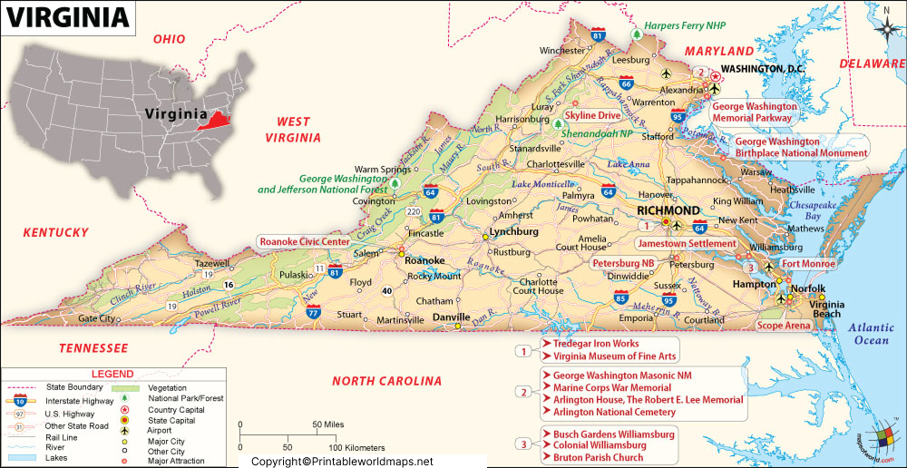
The map can be used to identify Virginia’s major geographic locations and understand the state’s position within the United States.
Labeled Map of Virginia Printable
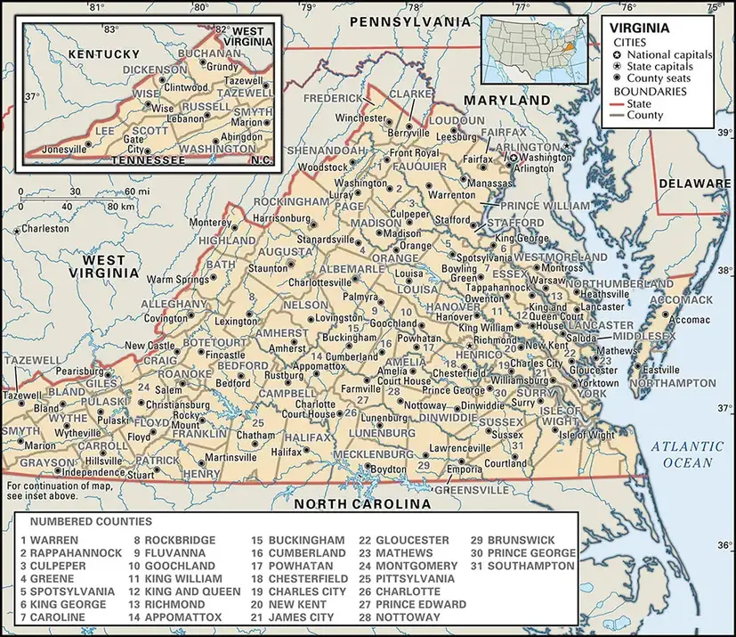
A Labeled Map of Virginia is particularly useful when you need a printable geographic reference for classroom activities, geography projects, state studies, or general reference.
The printable version can be downloaded and printed for educational or personal use, subject to the publisher’s stated usage terms.
Labeled Map of Virginia with Cities
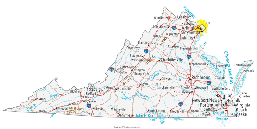
The Labeled Map of Virginia with Cities helps locate major population centers throughout the state. Important cities shown on Virginia maps can include Richmond, Virginia Beach, Norfolk, Chesapeake, Newport News, Alexandria, Hampton, and Roanoke.
Virginia’s independent cities are legally separate from counties and function as county-equivalent jurisdictions for many statistical purposes.
Major Cities in Virginia
| City | Location / significance |
|---|---|
| Richmond | State capital |
| Virginia Beach | Largest city by population |
| Norfolk | Major coastal and port city |
| Chesapeake | Large independent city in Hampton Roads |
| Arlington | Urban county bordering Washington, D.C. |
| Alexandria | Independent city in Northern Virginia |
| Newport News | Hampton Roads city and port |
| Hampton | Coastal city in Hampton Roads |
| Roanoke | Major city in western Virginia |
Population figures change over time, so current Census Bureau estimates should be used when an exact population figure is required.
Labeled Virginia Map with Capital
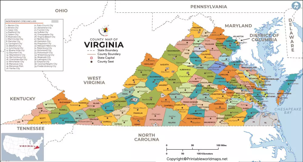
The Labeled Virginia Map with Capital identifies Richmond as the capital of the Commonwealth of Virginia.
Richmond is located along the James River in central Virginia. It became Virginia’s capital in 1780 after the capital was moved from Williamsburg. Richmond remains the center of Virginia’s state government, with the Virginia State Capitol located in the city.
Virginia Counties and Independent Cities
Virginia has a distinctive local-government structure. The Commonwealth currently has 95 counties and 38 independent cities. Unlike most states, Virginia’s independent cities are not part of counties.
This distinction is important when reading a Labeled Map of Virginia, because cities such as Richmond, Norfolk, Virginia Beach, and Alexandria appear as independent jurisdictions rather than municipalities located inside counties.
For official geographic and population information, the U.S. Census Bureau provides current data and geographic resources.
Virginia Geography and Major Rivers
A Labeled Map of Virginia can also help identify important physical features.
Virginia’s geography extends from the Atlantic coastal area and Chesapeake Bay through the Piedmont to the Blue Ridge and Appalachian regions in the west.
Important rivers associated with Virginia include:
- James River
- York River
- Rappahannock River
- Potomac River
- Shenandoah River
The Chesapeake Bay is one of the state’s most important geographic features and influences Virginia’s coastal geography, transportation, ecosystems, and economy.
Virginia Map for Students and Teachers
The Labeled Map of Virginia can be used for:
- Virginia geography lessons
- State capital activities
- Identifying major cities
- Geography worksheets
- Classroom presentations
- State research projects
- Homeschooling resources
- Travel and trip planning
- Printable geography references
A labeled map is especially useful when students need to connect place names with their geographic locations.
Interesting Facts About Virginia
Here are several useful facts that can add geographic context to the map:
- Richmond is the capital of Virginia.
- Virginia is officially known as the Commonwealth of Virginia.
- Virginia has 95 counties and 38 independent cities.
- Virginia borders the Atlantic Ocean through its eastern coastline.
- The Chesapeake Bay extends deeply into eastern Virginia and Maryland.
- Virginia’s landscape ranges from coastal lowlands to mountainous terrain in the west.
- Virginia is one of the states that form the broader Mid-Atlantic region.
- Virginia’s western boundary includes parts of the Appalachian Mountain system.
Why Use a Labeled Map of Virginia?
A labeled map provides more information than an outline map because important geographic names are already identified. Users can quickly locate cities, the state capital, rivers, boundaries, and other features without having to label the map themselves.
For students, it can support geography assignments. For travelers and researchers, it provides a convenient visual reference.
Frequently Asked Questions
What is the capital of Virginia?
Richmond is the capital of the Commonwealth of Virginia.
What does a labeled map of Virginia show?
A labeled Virginia map can show cities, the capital, boundaries, rivers, highways, counties, independent cities, and other geographic features depending on the map.
How many counties are in Virginia?
Virginia has 95 counties.
How many independent cities are in Virginia?
Virginia has 38 independent cities.
What is the largest city in Virginia?
Virginia Beach is Virginia’s most populous city according to recent U.S. Census Bureau population estimates.
What states border Virginia?
What states border Virginia?
Can I print the Virginia map?
Yes. The printable PDF versions provided on this page can be used as a convenient reference for printing, subject to the applicable usage terms.
Where is Richmond located?
Richmond is located in central Virginia along the James River.
Reference Links
https://www.census.gov/quickfacts/fact/table/VA
https://www.census.gov/geographies/reference-files/time-series/geo/gazetteer-files.html









