
Tennessee is a state in the southeastern United States. The Labeled Map of Tennessee below helps identify the state’s location, capital, major cities, counties, neighboring states, and important geographic features.
Tennessee became the 16th state of the United States on June 1, 1796. Its official nickname is the Volunteer State.
Labeled Map of Tennessee
The Labeled Map of Tennessee can be used to identify Tennessee’s position within the United States and understand its neighboring states and major geographic areas.
Tennessee borders eight states:
- Kentucky
- Virginia
- North Carolina
- Georgia
- Alabama
- Mississippi
- Arkansas
- Missouri
The Tennessee state government lists these eight states as its bordering states.
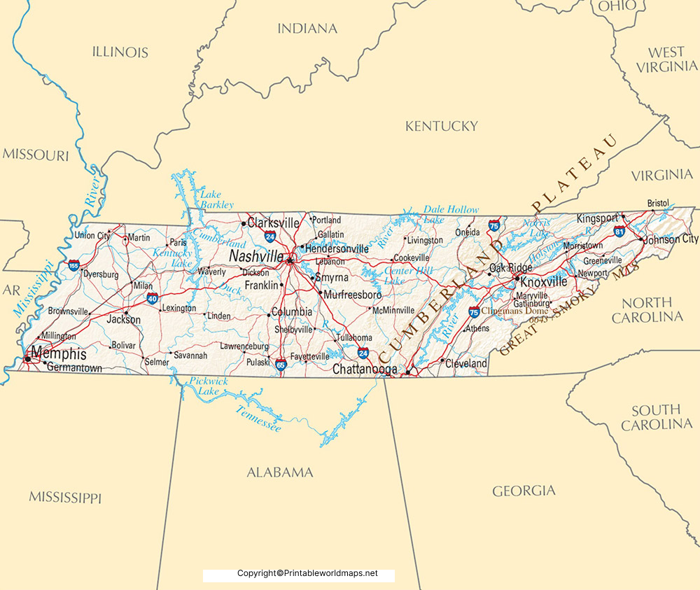
Tennessee Geography Facts
According to the State of Tennessee, the state covers approximately 42,146 square miles, including about 41,220 square miles of land and 926 square miles of water. Tennessee is approximately 491 miles long and 115 miles wide.
The state extends across three major geographic divisions:
- East Tennessee
- Middle Tennessee
- West Tennessee
These divisions are also represented by the three stars on the Tennessee state flag.
Labeled Map of Tennessee Printable
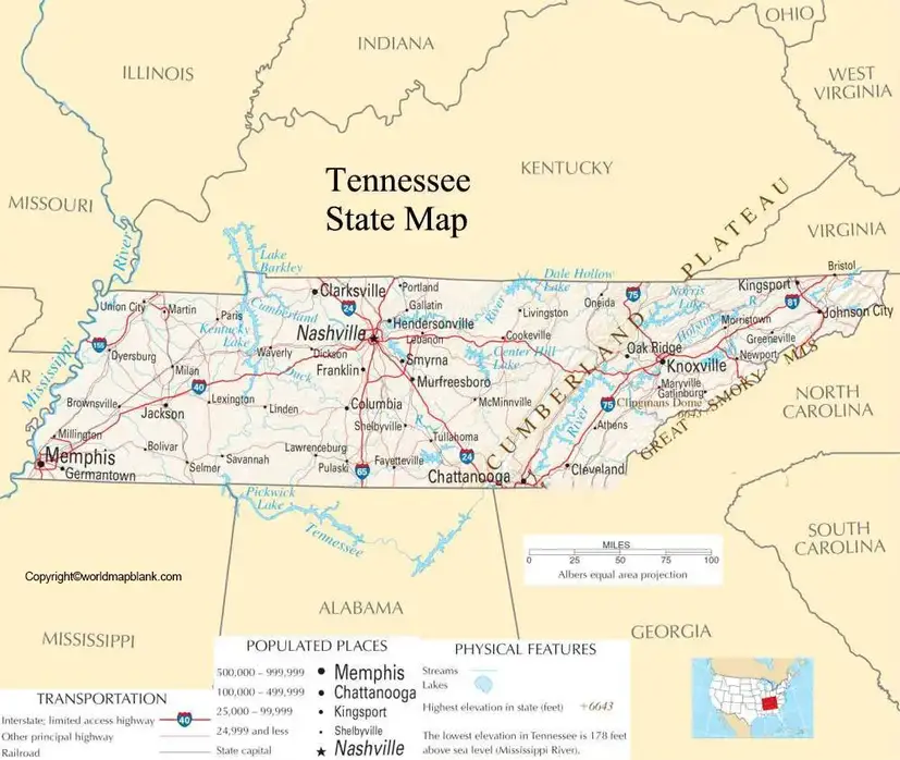
A printable Labeled Map of Tennessee can be useful for classroom activities, geography assignments, state studies, presentations, and general reference.
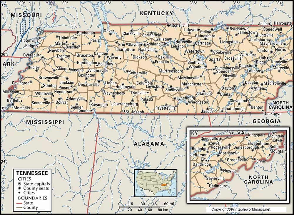
Tennessee has 95 counties. The 2020 Census recorded a total Tennessee population of 6,910,840. The U.S. Census Bureau’s latest QuickFacts page lists a July 1, 2025 population estimate of 7,315,076.
Because population figures change over time, current estimates should be distinguished from decennial Census counts.
Labeled Map of Tennessee with Cities
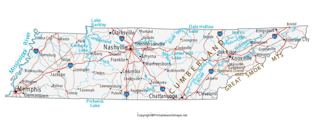
The Labeled Map of Tennessee with Cities makes it easier to locate some of the state’s best-known population centers.
Important Tennessee cities include:
- Nashville — state capital
- Memphis — major city in West Tennessee
- Knoxville — major city in East Tennessee
- Chattanooga — city in southeastern Tennessee
- Clarksville — city in northern Middle Tennessee
- Murfreesboro — city southeast of Nashville
For accurate current population figures, it is better to use U.S. Census Bureau data rather than older population estimates.
Labeled Tennessee Map with Capital
Nashville is the capital of Tennessee.
Nashville became Tennessee’s permanent capital in 1843. The Tennessee State Capitol was subsequently constructed in Nashville.
Nashville is also widely associated with the state’s music industry and is home to important cultural and educational institutions.
When using the Labeled Tennessee Map with Capital, Nashville can be identified in the central part of the state.
Major Rivers in Tennessee
Tennessee has several significant rivers and waterways that are important to the state’s geography and history.
Major rivers listed by the State of Tennessee include:
- Mississippi River
- Tennessee River
- Cumberland River
- Clinch River
- Duck River
- Hatchie River
- French Broad River
The state’s geography ranges from the Appalachian Mountains in the east to the flatter landscape of West Tennessee.
The Mississippi River forms part of Tennessee’s western boundary.
Tennessee’s Highest Point
The highest point in Tennessee is Clingmans Dome, located in the Great Smoky Mountains National Park.
The State of Tennessee lists its elevation as 6,643 feet.
This makes eastern Tennessee particularly important when studying the state’s physical geography.
Tennessee Counties
Tennessee is divided into 95 counties.
The 2020 Census recorded notable county populations including:
| County | 2020 Census population |
|---|---|
| Shelby County | 929,744 |
| Davidson County | 715,884 |
| Knox County | 478,971 |
| Hamilton County | 366,207 |
| Rutherford County | 341,486 |
| Williamson County | 247,726 |
| Montgomery County | 220,069 |
These figures are from the 2020 Census and should not be confused with newer population estimates.
For county-level geographic information, the U.S. Census Bureau provides official geographic and demographic datasets.
Tennessee State Nickname and Symbols
Tennessee is known as the Volunteer State. The nickname is associated with the state’s history of volunteer military service, particularly during the War of 1812.
Some official Tennessee symbols include:
- State nickname: Volunteer State
- State tree: Tulip Poplar
- State wild animal: Raccoon
- State flower: Iris
- State rock: Limestone
- State flag: Three stars representing East, Middle, and West Tennessee
The Tennessee government provides official information about the state’s symbols.
7 Useful Facts About Tennessee
- Tennessee became a U.S. state on June 1, 1796.
- Tennessee was the 16th state admitted to the Union.
- Nashville is the state capital.
- Tennessee has 95 counties.
- The 2020 Census recorded 6,910,840 residents.
- Tennessee borders eight states.
- Clingmans Dome is Tennessee’s highest point at 6,643 feet.
How to Use a Labeled Map of Tennessee
A Labeled Map of Tennessee can be useful for:
- School geography projects
- State reports
- Classroom worksheets
- Locating Tennessee cities
- Identifying neighboring states
- Learning Tennessee’s counties
- Studying rivers and physical geography
- Planning educational presentations
- Printing a reference map
For educational use, a labeled map can be combined with an unlabeled or blank Tennessee map to create geography practice exercises.
Frequently Asked Questions About the Labeled Map of Tennessee
What is the capital of Tennessee?
Nashville is the capital of Tennessee. The city was designated the state’s permanent capital in 1843.
How many states border Tennessee?
Tennessee borders eight states: Kentucky, Virginia, North Carolina, Georgia, Alabama, Mississippi, Arkansas, and Missouri.
How many counties are in Tennessee?
Tennessee has 95 counties.
When did Tennessee become a state?
Tennessee became the 16th U.S. state on June 1, 1796.
What is the largest city in Tennessee?
Memphis is the largest Tennessee city by population based on the 2020 Census city population data. For current city populations, consult the latest Census estimates.
What is Tennessee’s nickname?
Tennessee’s official nickname is the Volunteer State.
What is the highest point in Tennessee?
Clingmans Dome, in the Great Smoky Mountains National Park, is the highest point in Tennessee at 6,643 feet.
What are the three Grand Divisions of Tennessee?
Tennessee is commonly divided into East Tennessee, Middle Tennessee, and West Tennessee. The state’s flag represents these three divisions with three stars.
Where can I download a printable Tennessee map?
You can use the PNG and PDF map resources provided above to view or print the Labeled Map of Tennessee.
Reference Links
https://www.tn.gov/directory/county-city-web-sites.html
https://www.census.gov/quickfacts/fact/table/TN/PST040224
https://tigerweb.geo.census.gov/tigerwebmain/Files/acs26/tigerweb_acs26_county_2020_tab20_tn.html
https://www.tn.gov/about-tn/state-symbols.html
https://www.tn.gov/military/who-we-are/our-history-military.html









