
The Viking Map of the World helps readers explore the regions connected with Viking voyages, settlements, trade, and raids during the Viking Age. These historical maps offer a useful way to understand how Norse seafarers travelled from Scandinavia across parts of Europe and the North Atlantic.
Whether you are a student, teacher, history enthusiast, or geography learner, a printable Viking map can help you identify important locations and understand the geographical reach of Viking exploration. Explore the maps and PDF options below to support your historical research, classroom activities, and learning projects.

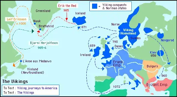
Viking Map of the World
A Viking map of the world is a visual guide to the regions associated with Viking-era travel, settlements, trading networks, and military expeditions. It can help readers understand the geographical connections between Scandinavia, the British Isles, continental Europe, Iceland, Greenland, and parts of the North Atlantic.
The Viking Age is commonly dated from approximately AD 800 to 1050, although historians use different dates depending on the region and historical event being studied. During this period, Norse communities developed extensive maritime networks that connected distant settlements and trading centres.
Viking expeditions were not limited to raiding. Norse people also traded goods, established settlements, explored new territories, served as mercenaries, and participated in political and cultural exchanges.
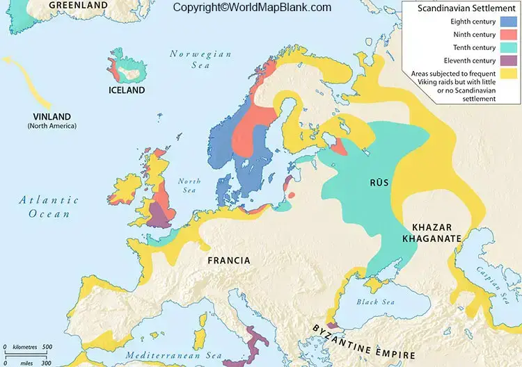
Old World Viking Map
An Old World Viking map illustrates the regions of Europe and the North Atlantic associated with Norse activity during the Viking Age. Depending on the map, it may highlight Scandinavian homelands, overseas settlements, trading centres, or areas reached by Viking expeditions.
Scandinavia, comprising present-day Norway, Denmark, and Sweden, was the main homeland of Viking communities. From this region, seafarers travelled along coastlines, crossed the North Sea, navigated European rivers, and sailed westward across the North Atlantic.
Historical maps should be interpreted carefully. A shaded region or marked territory does not necessarily indicate permanent Viking rule. Some places experienced raids, others developed trading connections or settlements, and some came under Norse political control for particular periods.
Printable Vikings Map of the World
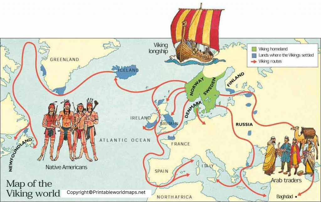
A printable Vikings map of the world is useful for geography lessons, history assignments, classroom displays, and personal research. A clear map can help learners locate Scandinavian countries and trace the broad directions of Viking travel.
Use the printable map to:
- Identify Norway, Denmark, and Sweden as the main Scandinavian homelands.
- Locate Iceland and Greenland in the North Atlantic.
- Explore Norse connections with the British Isles and continental Europe.
- Discuss the difference between raiding areas, trading networks, and permanent settlements.
- Compare historical Viking-era geography with a modern political map.
- For a convenient offline reference, download the PDF and print it using the paper size and orientation supported by your printer. Check the map’s labels and legend before using it in a school assignment or research project.
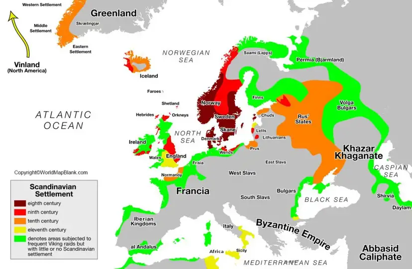
Viking Exploration Routes and Important Regions
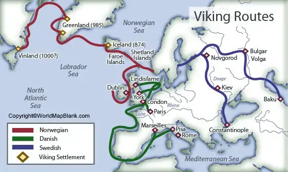
Viking travel connected several important regions across Europe and the North Atlantic. Understanding these connections provides more historical context than viewing a map as a simple illustration of conquered territory.
Norway, Denmark, and Sweden formed the central Scandinavian region associated with Viking communities. Coastal geography, shipbuilding, maritime knowledge, and access to the North Sea and Baltic Sea supported long-distance travel.
The British Isles
Viking expeditions reached parts of England, Scotland, Ireland, and surrounding islands. Some expeditions involved raids, while others led to settlements, trade, and lasting political changes.
Dublin became an important Norse settlement and trading centre, illustrating that Viking activity involved more than warfare.
Continental Europe
Norse groups travelled to coastal areas and navigable rivers in continental Europe. River routes connected the North Sea and Baltic regions with inland trading centres. Viking activity in these areas included commerce, warfare, political alliances, and settlement.
Iceland and Greenland
Norse settlers established communities in Iceland and Greenland during the Viking Age. These settlements formed important links in the North Atlantic, connecting Scandinavia with lands farther west.
North America
Archaeological evidence confirms a Norse presence at L’Anse aux Meadows in Newfoundland, Canada, around the year AD 1000. This UNESCO World Heritage Site is the earliest known evidence of European presence in North America.
The site demonstrates the remarkable maritime reach of Norse explorers. However, it should not be interpreted as proof that Vikings controlled the wider North American continent.
Important Facts About the Viking Age
The following facts provide additional historical context for readers studying a Viking map of the world.
- Historical period: The Viking Age is commonly dated to approximately AD 800–1050.
- Scandinavian origins: Viking communities originated primarily in present-day Norway, Denmark, and Sweden.
- Maritime expertise: Norse ships supported travel across open water, along coastlines, and through navigable rivers.
- Trade and exploration: Vikings participated in commercial networks as well as raids, warfare, and settlement.
- North Atlantic expansion: Norse communities established settlements in Iceland and Greenland and reached Newfoundland in North America.
- Changing political influence: Viking activity did not create one unified empire covering every region shown on a historical map.
- Cultural transformation: Scandinavia experienced major religious and political changes during the Viking Age, including the gradual adoption of Christianity.
How to Use a Viking Map for Learning
A printable Viking map can be used for more than identifying locations. Follow these steps to get more value from the map:
- Locate Scandinavia and identify Norway, Denmark, and Sweden.
- Find the British Isles, Iceland, Greenland, and Newfoundland.
- Trace any routes or regions marked on the map.
- Check whether the symbols indicate raids, settlements, trade routes, or areas of political control.
- Compare the historical map with a modern map to understand changes in borders and place names.
- Use reputable historical sources to verify important locations and dates.
For students, teachers, and history enthusiasts, combining a printable map with archaeological evidence and museum resources provides a more reliable understanding of Viking history.
Frequently Asked Questions About the Viking Map of the World
What is a Viking map of the world?
A Viking map of the world is a historical or educational map showing regions associated with Viking voyages, settlements, trading networks, and raids during the Viking Age.
Which countries were the Vikings originally from?
Viking communities originated primarily in Scandinavia, corresponding to present-day Norway, Denmark, and Sweden.
When was the Viking Age?
The Viking Age is commonly dated from approximately AD 800 to 1050. The exact dates can vary according to the region and the historical events being discussed.
Did Vikings reach North America?
Yes. Archaeological remains at L’Anse aux Meadows in Newfoundland, Canada, confirm a Norse presence in North America around AD 1000.
Can I download a printable Viking map of the world?
Yes. You can use the PDF links provided in this article to access the available printable maps. Check each file for readability, map labels, and print quality before using it for educational purposes.
Did Vikings control all the areas shown on Viking maps?
No. A map may show locations reached through voyages, raids, trade, or settlement. These activities did not necessarily mean that Vikings permanently ruled every marked region.
Why are Viking maps useful for students?
Viking maps help students understand historical geography, maritime exploration, settlement patterns, and the connections between Scandinavia, Europe, and the North Atlantic.
Where can I find reliable information about Viking history?
Reliable sources include UNESCO World Heritage Centre, the National Museum of Denmark, Parks Canada, and peer-reviewed archaeological research. These sources can help verify the dates, locations, and historical interpretations presented on educational maps.
Reference links
https://whc.unesco.org/en/list/4Copy link
https://parks.canada.ca/lhn-nhs/nl/meadows/culture/sagaCopy link
https://whc.unesco.org/en/list/1660/Copy link









