


The Jordan World Map helps you locate Jordan in Western Asia and understand its position in the Middle East. Jordan, officially known as the Hashemite Kingdom of Jordan, shares land borders with Syria, Iraq, Saudi Arabia, Israel, and the West Bank. It also has a short coastline along the Gulf of Aqaba, which connects the country to the Red Sea.
This guide includes a Jordan world map, printable map images, PDF resources, and geographical facts for students, teachers, travelers, and anyone learning about world geography.
Use the maps below to identify Jordan’s location, explore its neighboring countries, and understand its position on a world political map.
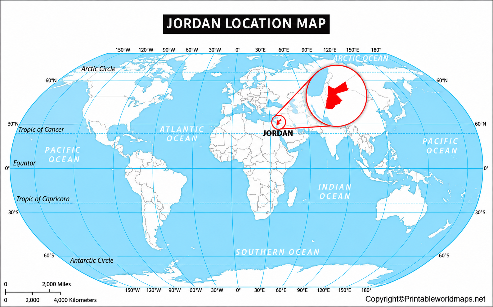
Jordan World Map
The Jordan world map highlights the country’s location within Western Asia. Jordan lies east of Israel and the West Bank, south of Syria, west of Iraq, and north of Saudi Arabia.

A world map is useful for understanding Jordan’s location relative to Asia, Africa, and Europe. Although Jordan is situated in Asia, its position near the eastern Mediterranean makes it an important geographical link between neighboring regions.
Where Is Jordan Located on the World Map?
A labeled Jordan world map helps readers identify the country’s location and nearby borders. It is particularly useful for school assignments, geography lessons, and reference work.

Jordan’s position is especially interesting because its western landscape includes the Jordan Valley and the Dead Sea, while large areas in the east and south consist of dry plateau and desert terrain.
When studying a political map, look for the country boundaries, capital city, neighboring countries, and major bodies of water. These features make it easier to understand Jordan’s regional position.
Jordan’s Neighboring Countries
Jordan shares land borders with several territories and countries:
- Syria: Located to the north.
- Iraq: Located to the northeast.
- Saudi Arabia: Located to the south and southeast.
- Israel: Located to the west.
- West Bank: Located along Jordan’s western side.
The political status and representation of international boundaries can vary between maps. For educational or official use, refer to a reputable map source and its boundary notes.

Printable Jordan on World Map
A printable Jordan world map is a practical resource for classroom activities, homework, travel preparation, and personal geography study. You can view the map online or download the available PDF for printing.

For the best printing results, check the PDF’s page size and print preview before printing. Use a color version when you need to distinguish Jordan from surrounding countries. A grayscale version may be sufficient for worksheets and labeling exercises.
A printable map is also useful for marking Amman, Aqaba, the Dead Sea, and Jordan’s neighboring countries. If you use a blank map, add a north arrow and labels to make your study activity more informative.
Jordan Map World Atlas
An atlas-style map provides a closer look at Jordan’s location, regional geography, and major places. Depending on the map’s level of detail, it may show cities, governorates, boundaries, rivers, and nearby countries.

Amman is Jordan’s capital and largest city. Other important places include Irbid in the north and Aqaba in the south. The country is divided into 12 governorates, which are administrative divisions used for local government and public services.
For students, an atlas-style map can help connect political geography with physical geography. Compare the location of settlements with the Jordan Valley, the Dead Sea, the highlands, and the eastern desert plateau.
Important Geographical Facts About Jordan
Jordan has a varied landscape despite its relatively small size. The country’s western side includes highlands and the Jordan Rift Valley, while much of the east and south is arid or semi-arid.
Here are some useful facts to remember when studying the Jordan world map:
- Official name: Hashemite Kingdom of Jordan.
- Capital and largest city: Amman.
- Official language: Arabic.
- Currency: Jordanian dinar (JOD).
- Administrative divisions: 12 governorates.
- Highest mountain: Jabal Umm ad Dami, approximately 1,854 metres above sea level.
- Notable geographical feature: The Dead Sea, located in the Jordan Rift Valley.
- Sea access: Jordan has a short coastline on the Gulf of Aqaba, an extension of the Red Sea.
The Dead Sea is famous for its exceptionally low elevation, while the Gulf of Aqaba gives Jordan access to maritime trade and coastal tourism. These features make the country particularly interesting to study on both political and physical maps.
Why Use a Jordan World Map?
A Jordan world map is helpful for more than simply finding a country. It can support several types of learning and research:
- School and college assignments: Identify Jordan and its neighboring countries.
- Political geography: Study country boundaries and regional relationships.
- Physical geography: Locate the Jordan Valley, Dead Sea, and Gulf of Aqaba.
- Travel planning: Understand the relative positions of Amman, Aqaba, and other destinations.
- Printable learning activities: Use labeled or blank maps for quizzes, worksheets, and classroom exercises.
Choose a map that matches your purpose. A world map is best for understanding Jordan’s global location, a political map is useful for boundaries, and a detailed atlas map is more suitable for studying cities and physical features.
Frequently Asked Questions
1. Where is Jordan located on the world map?
Jordan is located in Western Asia, in the Middle East. It borders Syria, Iraq, Saudi Arabia, Israel, and the West Bank.
2. What is the capital of Jordan?
Amman is the capital and largest city of Jordan. It is located in the northwestern part of the country.
3. Which continent is Jordan in?
Jordan is in Asia, specifically Western Asia.
4. Does Jordan have access to the sea?
Yes. Jordan has a short coastline on the Gulf of Aqaba, which connects to the Red Sea. Aqaba is the country’s principal coastal port.
5. Can I download a printable Jordan world map?
Yes. The map resources provided in this article include image and PDF versions. Open the relevant PDF link to view or print the map.
6. Which countries border Jordan?
Jordan shares land borders with Syria, Iraq, Saudi Arabia, Israel, and the West Bank. Maps may represent politically sensitive boundaries differently, so consult the map legend and source.
7. What is the Dead Sea’s importance to Jordan’s geography?
The Dead Sea lies along Jordan’s western side and is one of the region’s most distinctive geographical features. Its very low elevation makes it important in physical geography studies.
8. What is the highest mountain in Jordan?
Jabal Umm ad Dami, in southern Jordan, is commonly identified as the country’s highest mountain, at approximately 1,854 metres above sea level.
Reference links
https://jordan.gov.jo/En/Pages/About_Jordan
https://mota.gov.jo/EN/Pages/Welcome_To_Jordan
https://jordan.unfpa.org/en/about-jordan
https://jordanexportportal.gov.jo/menu-1/1-discover-facts-about-jordan
https://www.britannica.com/place/Jordan
https://www.cia.gov/the-world-factbook/countries/jordan/
