

Labeled Map of North Dakota helps you locate the state’s capital, major cities, counties, highways, rivers, and other geographic features. North Dakota is a landlocked state in the north-central United States, bordering South Dakota, Montana, Minnesota, and the Canadian provinces of Saskatchewan and Manitoba.
This page provides several Labeled Map of North Dakota options, including maps showing cities, the state capital, state boundaries, and other geographic information. Printable PNG and PDF versions are also provided for convenient reference.
North Dakota became a U.S. state on November 2, 1889. Its capital is Bismarck. The U.S. Census Bureau recorded a population of 779,094 in the 2020 Census and estimated the state’s population at 799,358 on July 1, 2025.
Labeled Map of North Dakota
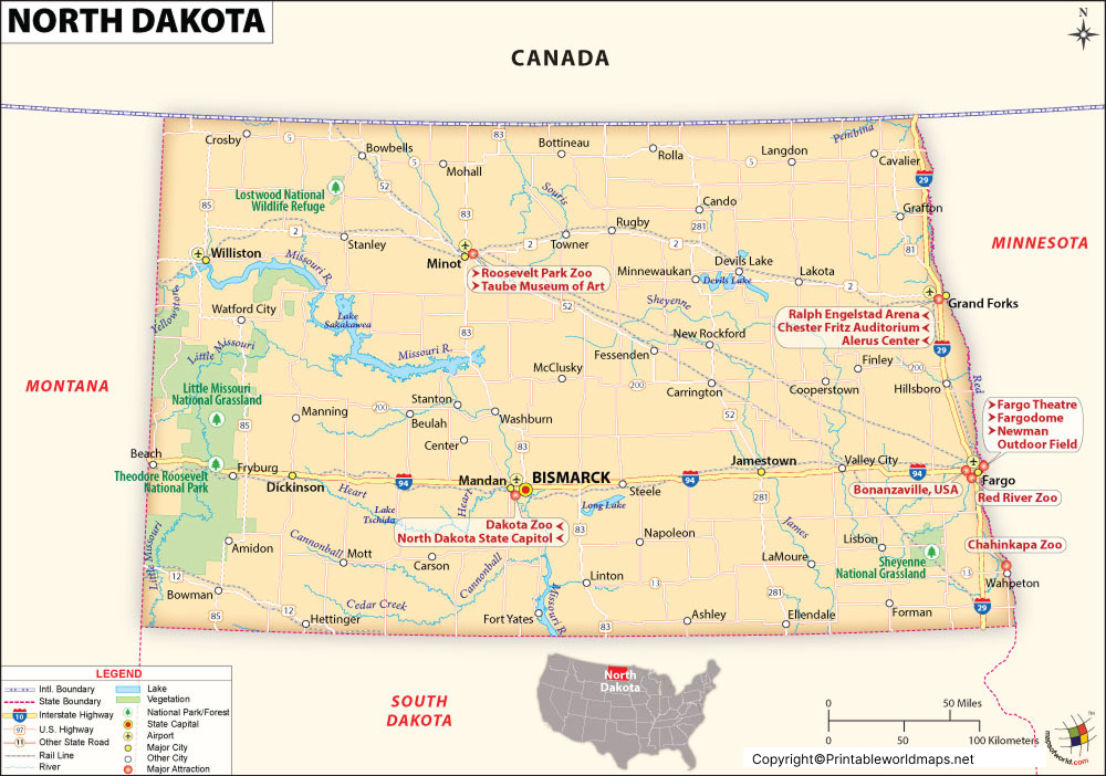
The Labeled Map of North Dakota below identifies important geographic features, including the state capital, cities, county boundaries, major highways, and other transportation features.
North Dakota covers approximately 70,704 square miles, according to the North Dakota Department of Transportation’s state transportation map.
The state’s eastern boundary follows the Red River, separating North Dakota from Minnesota. The Missouri River is another major geographic feature and flows through the central and western parts of the state.
North Dakota Geography at a Glance
| Feature | Information |
|---|---|
| State | North Dakota |
| Capital | Bismarck |
| Statehood | November 2, 1889 |
| 2020 Census population | 779,094 |
| 2025 population estimate | 799,358 |
| Area | About 70,704 square miles |
| Counties | 53 |
| Region | Northern Great Plains |
| Eastern border | Minnesota |
| Southern border | South Dakota |
| Western border | Montana |
| Northern border | Canada |
The capital city, Bismarck, had a 2020 Census population of 73,622, while Fargo had 125,990 residents in the 2020 Census. The Census Bureau estimated Fargo’s population at 136,275 in 2025.
Labeled Map of North Dakota Printable
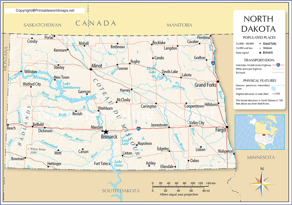
The Labeled Map of North Dakota Printable is useful for students, teachers, travelers, researchers, and anyone who needs a clear state reference map.
The state is divided into 53 counties. Official North Dakota mapping resources provide county boundaries, cities, highways, roads, and other geographic information.
What This Printable Map Shows
- North Dakota state boundaries
- Neighboring states and Canadian provinces
- County boundaries
- Major cities
- State capital
- Major highways
- Geographic orientation
- Selected transportation features
For authoritative geographic and transportation information, the North Dakota Department of Transportation provides downloadable GIS data and mapping resources.
Labeled Map of North Dakota with Cities
The Labeled Map of North Dakota with Cities makes it easier to identify important population centers throughout the state.
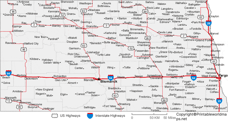
Some of the state’s best-known cities include:
- Fargo
- Bismarck
- Grand Forks
- Minot
- West Fargo
- Williston
- Dickinson
- Mandan
- Jamestown
- Wahpeton
The North Dakota Department of Commerce identifies Fargo, Bismarck, Grand Forks, Minot, West Fargo, Williston, Dickinson, Mandan, Jamestown, Wahpeton, Devils Lake, Watford City, and Valley City among communities included in its population-focused state data resources.
The U.S. Census Bureau’s 2020 incorporated-place data provides population and geographic information for cities throughout North Dakota.
Labeled North Dakota Map with Capital
The Labeled North Dakota Map with Capital identifies Bismarck, the capital of North Dakota.
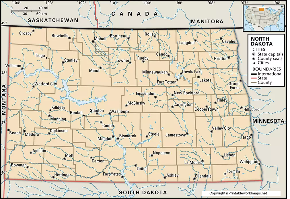
Bismarck is located along the Missouri River and serves as the state capital. North Dakota’s official state government identifies Bismarck as the capital city.
According to the U.S. Census Bureau, Bismarck had 73,622 residents in the 2020 Census, and its estimated population was 77,963 on July 1, 2025.
Bismarck is also the seat of Burleigh County and an important center for government, business, healthcare, transportation, and services in central North Dakota.
North Dakota Map with Counties
North Dakota has 53 counties, each with its own county government and geographic boundaries.
A county map can be useful when studying:
- County locations
- County seats
- Regional geography
- Transportation networks
- Population distribution
- Local government areas
The official North Dakota Department of Transportation state base map displays county boundaries, county names, cities, interstate highways, U.S. highways, and state highways.
For users requiring GIS information, the NDDOT also provides downloadable geographic data and mapping applications.
Major Rivers and Geographic Features of North Dakota
North Dakota’s geography includes broad plains, agricultural areas, river valleys, and important waterways.
Major rivers associated with the state include:
- Missouri River
- Red River
- Sheyenne River
- James River
The Red River forms much of the eastern boundary between North Dakota and Minnesota, while the Missouri River is a major waterway crossing the state.
These geographic features can be useful when interpreting a Labeled Map of North Dakota, particularly maps showing physical geography or transportation routes.
Major Cities in North Dakota
For a quick geographic reference, these are several major North Dakota cities:
| City | 2020 Census population |
|---|---|
| Fargo | 125,990 |
| Bismarck | 73,622 |
| Grand Forks | 59,166 |
| Minot | 48,377 |
| West Fargo | 38,626 |
| Williston | 29,160 |
| Dickinson | 25,679 |
| Mandan | 24,206 |
Population figures above refer to the 2020 U.S. Census rather than current estimates. For current population figures, the Census Bureau’s Quick Facts pages should be consulted.
North Dakota Map for Students and Teachers
A Labeled Map of North Dakota can be useful in geography and social studies lessons.
Students can use the map to identify:
- North Dakota’s capital
- Major cities
- Counties
- Neighboring states
- Canada
- Major rivers
- Highways
- Geographic regions
Teachers can use the printable PNG and PDF maps for classroom worksheets, geography assignments, presentations, and study materials.
North Dakota Map for Travel and Planning
A labeled state map can also help with basic trip planning and geographic orientation.
The North Dakota Department of Transportation publishes official state transportation maps showing highways, roads, cities, county boundaries, and other transportation information.
For detailed route planning, users should verify current road conditions and transportation information through official North Dakota resources rather than relying solely on a static map.
North Dakota Map Facts
Here are some useful facts to remember:
- Bismarck is the capital of North Dakota.
- North Dakota became a state on November 2, 1889.
- The state has 53 counties.
- The 2020 Census population was 779,094.
- The 2025 Census Bureau population estimate was 799,358.
- Fargo was the largest North Dakota city by 2020 Census population among the cities listed above, with 125,990 residents.
- Bismarck is located along the Missouri River.
- North Dakota borders South Dakota, Montana, Minnesota, Saskatchewan, and Manitoba.
- North Dakota is part of the Great Plains.
- Official state transportation maps include highways, cities, county boundaries, and other map features.
How to Use the Labeled Map of North Dakota
You can use these maps for several purposes:
Education: Identify cities, counties, rivers, and state boundaries.
Research: Use the map as a geographic reference when studying North Dakota.
Travel: Understand the general location of cities and transportation routes.
Printing: Download the available PNG or PDF versions for offline use.
Presentations: Use a labeled state map when explaining North Dakota geography.
Frequently Asked Questions
What is the capital of North Dakota?
Bismarck is the capital city of North Dakota.
How many counties are in North Dakota?
North Dakota has 53 counties.
What is the largest city in North Dakota?
Fargo had 125,990 residents in the 2020 Census, making it the largest incorporated city in the state by that Census count.
What is the population of North Dakota?
The 2020 Census counted 779,094 people in North Dakota. The U.S. Census Bureau estimated the population at 799,358 on July 1, 2025.
When did North Dakota become a state?
North Dakota became a state on November 2, 1889.
What cities are shown on a North Dakota cities map?
Commonly identified cities include Fargo, Bismarck, Grand Forks, Minot, West Fargo, Williston, Dickinson, Mandan, and Jamestown.
Where is Bismarck located?
Bismarck is located in central North Dakota along the Missouri River and is the state’s capital.
Does the North Dakota map include counties?
Yes. North Dakota has 53 counties, and official state maps can display county boundaries and county names.
Can I print the North Dakota map?
Yes. The maps on this page can be provided in PNG and PDF formats for printing and offline reference.
Where can I find official North Dakota map data?
The North Dakota Department of Transportation provides official GIS data, mapping applications, and transportation maps.
Reference Links
https://www.census.gov/quickfacts/fact/map/ND/POP010220
https://www.census.gov/quickfacts/fact/table/bismarckcitynorthdakota/POP060220
https://www.census.gov/quickfacts/fact/table/fargocitynorthdakota/PST040224
https://tigerweb.geo.census.gov/tigerwebmain/Files/acs26/tigerweb_acs26_incplace_2020_tab20_nd.html
https://www.nd.gov/government/fun-facts
https://www.nd.gov/state-facts/origin-name
https://www.dot.nd.gov/construction-and-planning/planning-process/gis-and-mapping
https://www.dot.nd.gov/sites/www/files/documents/gis%20and%20mapping/ND-Tourism-Road-Map.pdf
