

The Labeled Map of Idaho helps you locate Idaho’s state capital, major cities, county boundaries, rivers, and neighboring states. Whether you are studying U.S. geography, planning a trip, or looking for a printable reference, these Idaho maps make it easier to understand the state’s layout.
Idaho is located in the northwestern United States and is known for its mountains, forests, rivers, farmland, and outdoor recreation areas. It shares borders with Washington, Oregon, Nevada, Utah, Wyoming, Montana, and the Canadian province of British Columbia.
Idaho’s capital and most populous city is Boise, located in the southwestern part of the state. Idaho has 44 counties and became the 43rd state of the United States on July 3, 1890. According to the U.S. Census Bureau’s July 2025 population estimate, Idaho had approximately 2.03 million residents.
Use the labeled maps below to explore Idaho’s cities, counties, state capital, and important geographic features.
Labeled Map of Idaho
The labeled map of Idaho shows the state’s outline and the locations of important cities and geographic features. Depending on the map version, labels may identify the state capital, city names, rivers, highways, lakes, and surrounding state boundaries.
Idaho’s landscape varies considerably from north to south. The northern region contains extensive forests, lakes, and mountainous terrain, while southwestern Idaho includes the Boise metropolitan area and productive agricultural land. The Snake River Plain crosses much of southern Idaho and contains several of the state’s important population centers.
Use this map as a general geographic reference for identifying Idaho’s location and understanding how its cities and physical features are distributed.

Labeled Map of Idaho Printable
A printable Idaho map is useful for classroom activities, geography assignments, trip planning, and personal reference. You can print the map to identify the state’s outline, locate major cities, and review the relationships between Idaho and its neighboring states.
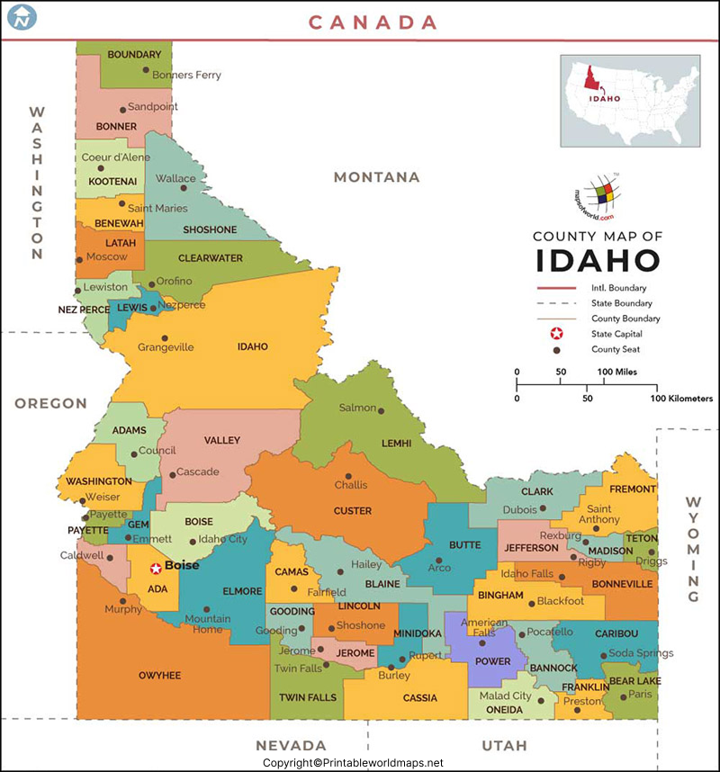
Idaho covers approximately 83,557 square miles of land, according to Idaho’s official state facts. Its nickname is the Gem State, reflecting its association with a variety of gemstones and natural resources.
For the clearest results, choose a PDF when printing a map for a worksheet or study guide. Check the map legend and labels before using it for detailed navigation, because a general-purpose map may not show every road, settlement, or boundary.
Labeled Map of Idaho with Cities
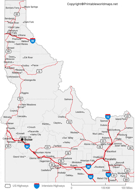
The labeled map of Idaho with cities helps readers identify important urban areas across the state. Boise is Idaho’s capital and largest city by population. Other major population centers include Meridian, Nampa, Idaho Falls, Caldwell, Pocatello, Coeur d’Alene, and Twin Falls.
These cities serve different regional roles. Boise is a major center for government, business, and services. Meridian and Nampa are part of the rapidly growing southwestern metropolitan area, while Idaho Falls is an important regional center in eastern Idaho. Coeur d’Alene serves northern Idaho, and Twin Falls is a prominent city in the south-central region.
The map is helpful for comparing city locations and understanding the distances between Idaho’s principal urban areas. Remember that city boundaries, metropolitan areas, and population rankings are different measures, so a city map should be read alongside the relevant geographic or census data when precise information is required.
Labeled Idaho Map with Capital
Boise is the capital of Idaho and the seat of Ada County. It lies in southwestern Idaho along the Boise River, near the western edge of the Rocky Mountain region. The city is an important center for state government, education, commerce, healthcare, and transportation.
The Idaho State Capitol building is located in downtown Boise. Other notable attractions include the Boise Art Museum and the Idaho Botanical Garden. Boise Airport provides commercial air service to the region.
A labeled Idaho capital map helps you find Boise in relation to other major cities and neighboring states. It is particularly useful for students learning U.S. state capitals, visitors planning a trip, and readers who need a quick geographic overview.
Idaho Counties Map: Understanding the 44 Counties
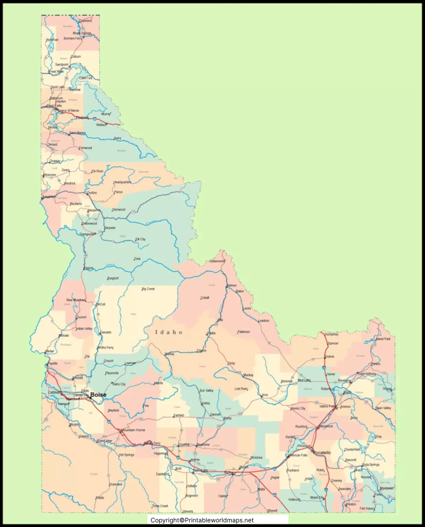
Idaho is divided into 44 counties, each with its own local government structure. County boundaries help identify local administrative areas and are useful for studying demographics, public services, elections, and regional geography.
Ada County includes Boise, while Canyon County includes Nampa and Caldwell. In northern Idaho, Kootenai County includes Coeur d’Alene. Bonneville County includes Idaho Falls, and Bannock County includes Pocatello.
A county map differs from a city map: counties cover larger administrative areas and can contain multiple cities, towns, and unincorporated communities. If you need county seats, official boundaries, or local road information, consult an authoritative state or federal mapping source.
For official geographic data, visit the U.S. Census Bureau’s Idaho geographic profile.
Major Rivers and Geographic Features of Idaho
Idaho’s rivers, mountains, valleys, and plains are important features to look for on a physical or labeled map. The Snake River is one of the state’s principal waterways and flows across southern Idaho. Other significant rivers include the Salmon, Clearwater, Boise, Payette, and Bear rivers.
The Snake River Plain is a major geographic feature of southern Idaho. The central and northern parts of the state include rugged mountain ranges and extensive forested areas. These physical features influence transportation routes, agriculture, recreation, and the distribution of communities.
A general labeled map may show only selected rivers and landmarks. For detailed hydrology, terrain, or elevation information, use a specialized physical map or official geographic dataset.
Neighboring States and Idaho’s Location
Idaho borders six U.S. states: Washington, Oregon, Nevada, Utah, Wyoming, and Montana. It also shares an international boundary with British Columbia, Canada.
Its location makes Idaho a useful geographic connection between the Pacific Northwest and the interior western United States. Highways and other transport routes connect its population centers with surrounding states.
When using a state map for travel, remember that a simple labeled map is not a substitute for current road conditions, construction notices, or turn-by-turn navigation. Check official transportation resources before beginning a journey.
How to Use and Print an Idaho Map
Follow these steps to get the most value from the maps on this page:
- Choose the right map. Use a city map to locate population centers, a capital map to identify Boise, or a county map to study administrative boundaries.
- Open the full-size image. This makes small city names and geographic labels easier to read.
- Download the PDF version. A PDF is often more convenient for printing and classroom use.
- Check the legend and date. Map details can differ by edition, and road networks or administrative information may change.
- Use official sources for detailed work. Consult government mapping resources when you need current transportation data, official boundaries, or census figures.
For travel planning, consider using the official Idaho state highway map and travel resources.
Frequently Asked Questions About Idaho Maps
What is the capital of Idaho?
Boise is the capital of Idaho. It is located in southwestern Idaho and is also the state’s most populous city.
How many counties are there in Idaho?
Idaho has 44 counties. County maps help readers identify administrative boundaries and understand how local areas are organized.
What are the major cities in Idaho?
Major cities include Boise, Meridian, Nampa, Caldwell, Idaho Falls, Pocatello, Coeur d’Alene, Twin Falls, and Post Falls. Their populations and rankings vary by census year.
Where is Idaho located in the United States?
Idaho is in the northwestern United States. It borders Washington, Oregon, Nevada, Utah, Wyoming, Montana, and British Columbia in Canada.
Can I print the labeled map of Idaho?
Yes. The map links on this page include printable PDF versions. Open a PDF and use your browser’s print option or save the file for later use.
What is Idaho’s nickname?
Idaho is commonly known as the Gem State.
What is the largest city in Idaho?
Boise is Idaho’s largest city by population. The U.S. Census Bureau estimated Boise’s population at approximately 238,429 in July 2025.
Where can I find an official Idaho road map?
The Idaho Transportation Department provides official road and geographic mapping resources. Visit its GIS Maps and Data page for transportation-related information.
Reference links
https://www.census.gov/quickfacts/fact/table/ID/SBO020223
https://data.census.gov/profile?g=040XX00US16
https://itd.idaho.gov/gis-maps
https://visitidaho.org/explore-idaho/maps-and-publications
https://apps.itd.idaho.gov/Apps/info/Idaho_State_Map.pdf
https://developers.google.com/search/docs/fundamentals/creating-helpful-content
