

Alaska is the largest U.S. state by total area and is located in the far northwestern part of North America. This Labeled Map of Alaska helps identify the state’s capital, major cities, geographic regions, rivers, and other important locations.
Alaska covers 665,384 square miles (1,723,337 square kilometers), including land and water area, according to U.S. Census Bureau geographic measurements.
Unlike most U.S. states, Alaska does not share a land border with another U.S. state. It borders Canada to the east and has maritime boundaries across the Bering Strait region toward Russia.
Alaska became the 49th U.S. state on January 3, 1959. Its nickname is “The Last Frontier,” and its state motto is “North to the Future.”
Labeled Map of Alaska
This Labeled Map of Alaska shows the state’s geographic position and provides a useful reference for locating major areas and communities.
Alaska is separated from the contiguous United States by Canada and has coastlines along the Arctic Ocean, Pacific Ocean, Bering Sea, and associated waters.
According to the U.S. Census Bureau, Alaska had a population of 733,391 in the 2020 Census and an estimated population of 737,270 on July 1, 2025.
Alaska’s total area is 665,384 square miles (1,723,337 square kilometers), making it the largest U.S. state by area.
The state is geographically diverse, with Arctic tundra in the north, large interior regions, extensive mountain ranges, glaciers, forests, islands, and coastal communities.
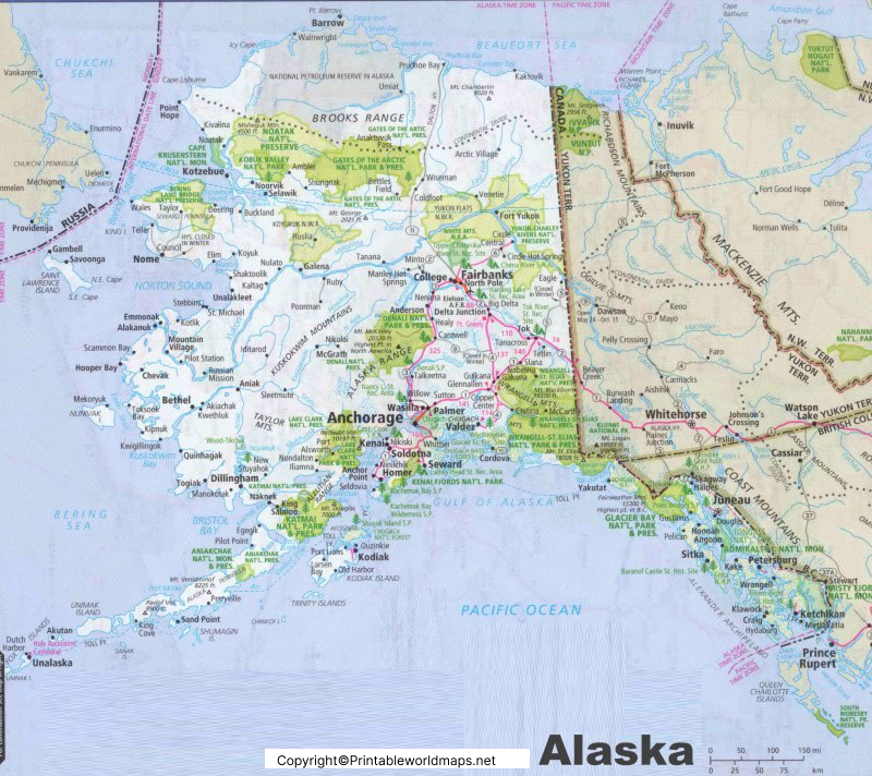
What Does a Labeled Map of Alaska Show?
A labeled map can help users quickly locate:
- Alaska’s capital city, Juneau
- Major cities such as Anchorage and Fairbanks
- Important rivers and mountain ranges
- Major geographic regions
- Coastal areas and island groups
- National parks and other prominent landmarks
- Major communities and transportation routes
For students, teachers, travelers, and geography researchers, a labeled map provides a convenient visual reference alongside Alaska’s geographic facts.
Labeled Alaska Map Printable
A Labeled Alaska Map Printable is useful for classroom activities, geography assignments, travel planning, and general reference.
The map can be used to identify major geographic features, cities, waterways, and regions without requiring an online interactive map.
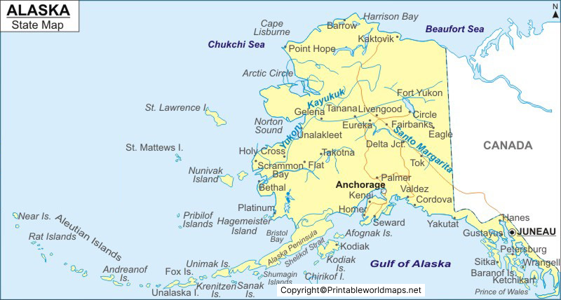
Major Rivers in Alaska
Alaska has an extensive network of rivers and streams. Some important rivers associated with the state include:
- Yukon River
- Kuskokwim River
- Copper River
- Tanana River
- Susitna River
- Colville River
- Noatak River
- Koyukuk River
The Yukon River is one of Alaska’s most important river systems. Its basin covers more than 330,000 square miles across Alaska and Canada, according to the U.S. Geological Survey.
Alaska’s Geographic Regions
Alaska is commonly discussed through broad geographic areas, although different government agencies and organizations may divide the state into regions differently.
For general map-reading purposes, major areas include:
- Arctic Alaska
- Interior Alaska
- Southcentral Alaska
- Southwest Alaska
- Southeast Alaska
Southeast Alaska includes the Inside Passage and communities such as Juneau, Sitka, and Ketchikan. The region contains extensive coastal mountains, islands, forests, and waterways.
Labeled Map of Alaska with Cities
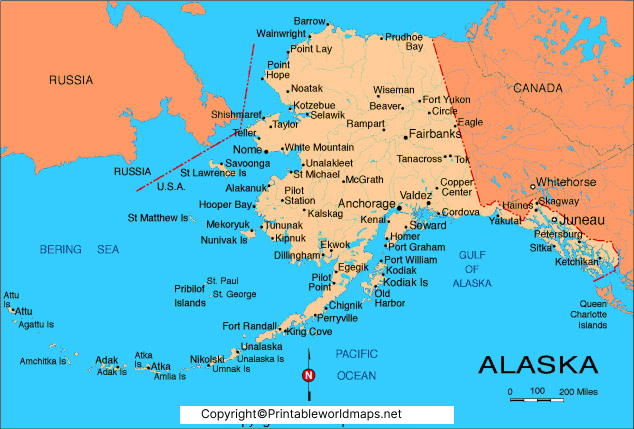
The Labeled Map of Alaska with Cities helps users locate major population centers and communities throughout the state.
Important cities and communities shown or commonly referenced on Alaska maps include:
- Anchorage
- Fairbanks
- Juneau
- Wasilla
- Sitka
- Ketchikan
- Kenai
- Kodiak
- Bethel
- Nome
- Palmer
- Soldotna
- Valdez
Anchorage is Alaska’s largest city and the state’s primary population and economic center. Fairbanks is a major Interior Alaska city, while Juneau serves as the state capital.
When using a city map, remember that Alaska’s communities are widely dispersed across a very large geographic area.
Labeled Alaska Map with Capital
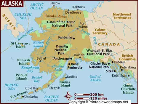
Juneau is the capital of Alaska. It is located in Southeast Alaska along the Gastineau Channel.
Juneau became Alaska’s political center after government offices moved from Sitka in 1906. Juneau was subsequently retained as the capital when Alaska became a territory and later achieved statehood in 1959.
One distinctive feature of Juneau is its geographic setting. The city is surrounded by mountains and waterways and is not connected to Alaska’s road network with a highway extending to the rest of the state. Alaska’s official information also identifies Juneau as the state capital.
Why Is Juneau the Capital of Alaska?
Juneau’s importance developed during the late 19th-century gold-mining period. The city grew as a center of government, mining, commerce, and transportation.
The move of government offices from Sitka to Juneau took place in 1906. The city’s role as the political center continued through Alaska’s territorial period and statehood.
Alaska Map: Important Geographic Facts
Here are some useful facts to understand while reading an Alaska map:
| Feature | Alaska Fact |
|---|---|
| U.S. State | 49th state |
| Statehood | January 3, 1959 |
| Capital | Juneau |
| Largest City | Anchorage |
| Nickname | The Last Frontier |
| Motto | North to the Future |
| Total Area | 665,384 sq mi / 1,723,337 sq km |
| 2020 Census Population | 733,391 |
| 2025 Population Estimate | 737,270 |
| Highest Mountain | Denali / Mount McKinley |
| Highest Elevation | 20,310 ft / 6,190 m |
| Major River | Yukon River |
| Federally Recognized Tribes | 229 |
| Official Alaska Native Languages | 20 |
Population figures above use the latest U.S. Census Bureau QuickFacts data available for Alaska.
Interesting Facts About Alaska
1. Alaska Is the Largest U.S. State
Alaska has a total area of 665,384 square miles, more than twice the area of Texas. The U.S. Census Bureau’s state-area measurements place Alaska first among U.S. states by total area.
2. Alaska Has North America’s Highest Mountain
Denali, also known as Mount McKinley, reaches 20,310 feet (6,190 meters) above sea level. It is the highest mountain in North America.
3. Alaska Has 229 Federally Recognized Tribes
Alaska is home to 229 federally recognized Tribes, representing diverse Indigenous communities and cultures.
4. Alaska Recognizes 20 Alaska Native Languages
The State of Alaska recognizes 20 Alaska Native languages. These languages represent a major part of Alaska’s Indigenous cultural heritage.
5. The Yukon River Is a Major Alaska Waterway
The Yukon River flows through Canada and Alaska and drains a basin of more than 330,000 square miles. It is one of the major river systems of the region.
6. Alaska Has 30 Borough/Census-Area Geographic Units
Unlike most states, Alaska does not use counties in the same way as the contiguous states. Alaska’s Department of Health describes 19 boroughs and 11 Census Bureau-designated census areas, totaling 30 geographic units equivalent to counties for many statistical purposes.
7. Juneau Has a Unique Location
Juneau is the state capital, but its geographic location means it is not connected by a conventional road network to the rest of Alaska. Its history as the political center dates to the early 20th century.
Alaska Map for Students and Geography Research
A labeled Alaska map can be useful for:
- School geography projects
- U.S. state map assignments
- Learning Alaska’s major cities
- Identifying the state capital
- Understanding Alaska’s geographic regions
- Locating major rivers and mountains
- Travel and trip planning
- Printable classroom activities
- Geography quizzes and worksheets
For educational use, pairing the map with official population, area, geographic, and government information provides a more reliable reference than relying on map labels alone.
Frequently Asked Questions About a Labeled Map of Alaska
What is the capital of Alaska?
Juneau is the capital of Alaska. Government offices moved from Sitka to Juneau in 1906, and Juneau remained the capital through territorial government and statehood.
What is the largest city in Alaska?
Anchorage is the largest city in Alaska by population.
What is the largest state in the United States?
Alaska is the largest U.S. state by total area, covering 665,384 square miles.
What is the population of Alaska?
The 2020 Census counted 733,391 people in Alaska. The U.S. Census Bureau estimated the population at 737,270 on July 1, 2025.
What is the highest mountain in Alaska?
Denali, also known as Mount McKinley, is the highest mountain in Alaska and North America at 20,310 feet.
What is Alaska’s nickname?
Alaska’s official nickname is “The Last Frontier.”
When did Alaska become a state?
Alaska became the 49th U.S. state on January 3, 1959.
Which countries are near Alaska?
Alaska shares a land border with Canada. Across the Bering Strait region, Alaska is geographically close to Russia.
What are the major cities shown on an Alaska map?
Major cities and communities include Anchorage, Fairbanks, Juneau, Wasilla, Sitka, Ketchikan, Kenai, Kodiak, Bethel, Nome, Palmer, Soldotna, and Valdez.
How can I use a printable Alaska map?
A printable Alaska map can be used for classroom assignments, geography practice, travel planning, presentations, worksheets, and general reference.
Reference link
https://www.census.gov/quickfacts/fact/table/AK/INC110223
https://www.census.gov/geographies/reference-files/2010/geo/state-area.html
https://www.alaska.gov/kids/student.htm
https://www.alaska.gov/kids/learn/region.htm
https://dnr.alaska.gov/parks/oha/clg/AlaskaCLGs/Juneau.htm
