

Labeled Map of Arizona helps identify the state capital, major cities, counties, rivers, and important geographic regions. Arizona is located in the southwestern United States and is known for its diverse landscapes, including the Grand Canyon, Colorado Plateau, Sonoran Desert, and forested highlands.
Arizona became the 48th state of the United States on February 14, 1912. Its capital and largest city is Phoenix. The state has 15 counties, and the U.S. Census Bureau estimated Arizona’s population at 7,623,818 on July 1, 2025.
The map resources below are useful for students, teachers, researchers, travelers, and anyone looking for a clear reference map of Arizona.
Labeled Map of Arizona
The Labeled Map of Arizona shows the state’s major geographic features and provides a convenient reference for locating important places.
Arizona borders California and Nevada to the west, Utah to the north, New Mexico to the east, and Mexico to the south. Arizona also meets Colorado, New Mexico, Utah, and Arizona at the Four Corners, the only location in the United States where four states meet at a single point.
Arizona’s landscapes vary significantly from north to south. The northern part of the state includes the Colorado Plateau, while the southern part includes extensive desert landscapes. The Grand Canyon is one of the state’s most recognized geographic features, and Arizona’s official state nickname is The Grand Canyon State.
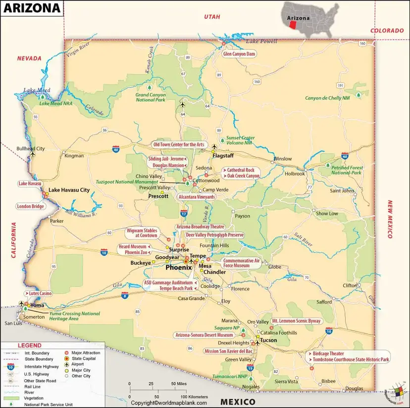
Labeled Map of Arizona Printable
The Labeled Map of Arizona Printable is useful for classroom activities, geography lessons, state projects, travel planning, and general reference.
Arizona contains 15 counties:
- Apache County
- Cochise County
- Coconino County
- Gila County
- Graham County
- Greenlee County
- La Paz County
- Maricopa County
- Mohave County
- Navajo County
- Pima County
- Pinal County
- Santa Cruz County
- Yavapai County
- Yuma County
The Arizona Secretary of State’s educational material confirms that Arizona has 15 counties and lists all of them.
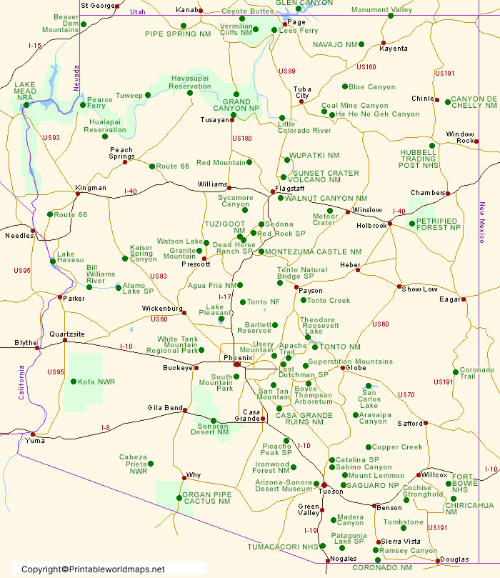
Labeled Map of Arizona with Cities
The Labeled Map of Arizona with Cities helps locate some of the state’s largest and best-known population centers.
Major Arizona cities commonly shown on reference maps include:
- Phoenix
- Tucson
- Mesa
- Chandler
- Scottsdale
- Glendale
- Gilbert
- Tempe
- Peoria
- Surprise
Phoenix is the state capital and the largest city in Arizona. The U.S. Census Bureau publishes annual population estimates for Arizona’s incorporated places, including city and town estimates through July 1, 2025.
For current city population information, it is better to use the latest Census estimates rather than older population figures from the 2020 Census.
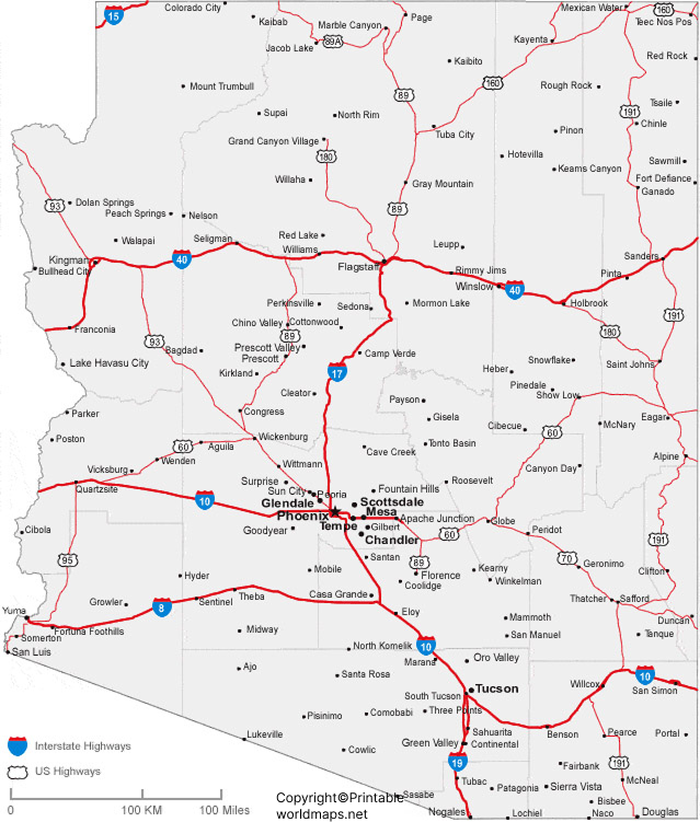
Labeled Arizona Map with Capital
The Labeled Arizona Map with Capital identifies Phoenix, the capital city of Arizona.
Phoenix is located in central Arizona within the Valley of the Sun. It serves as the state’s governmental center and is also one of the largest urban areas in the southwestern United States.
Older versions of this page stated that Phoenix had a population of 1,615,017 and described it as the fifth-largest U.S. city. Those figures should not be presented as current because city population rankings and estimates change over time. The U.S. Census Bureau’s current population datasets provide the appropriate source for updated city statistics.
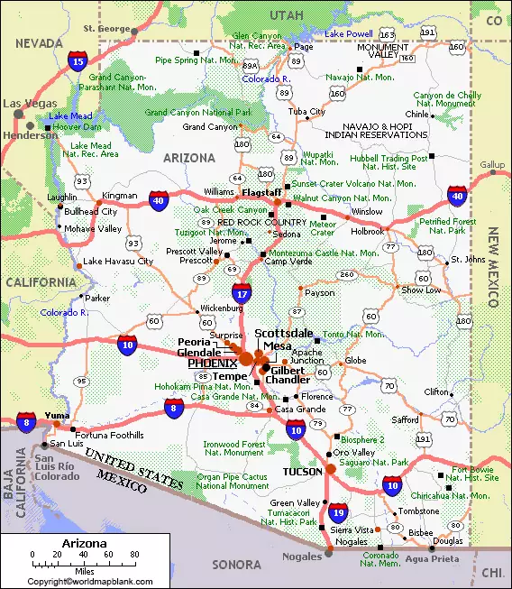
Arizona Geography and Regions
Arizona has a varied physical landscape despite being widely associated with desert terrain.
Three broad geographic areas are commonly used to describe the state’s landscape:
Colorado Plateau
The Colorado Plateau covers much of northern Arizona. It includes high-elevation landscapes and major features such as the Grand Canyon.
Transition Zone
The central part of Arizona contains mountainous and transitional landscapes between the higher Colorado Plateau and the lower desert regions.
Basin and Range
Southern and western Arizona include extensive basin-and-range terrain characterized by mountain ranges separated by broad valleys.
This geographic diversity means Arizona includes deserts, forests, mountains, plateaus, canyons, and river valleys.
Major Rivers in Arizona
The Labeled Map of Arizona can also help identify important rivers and waterways.
Major rivers and waterways associated with Arizona include:
- Colorado River
- Gila River
- Little Colorado River
- Salt River
- Verde River
- Santa Cruz River
- San Pedro River
- Agua Fria River
- Hassayampa River
The Colorado River forms much of Arizona’s western boundary. The Little Colorado River is an important tributary of the Colorado River and joins it within the Grand Canyon region. The U.S. Geological Survey maintains scientific and water-monitoring information for Arizona’s rivers and streams.
Arizona Population and Key Facts
Here are several useful facts to accompany the Labeled Map of Arizona:
| Fact | Information |
|---|---|
| State | Arizona |
| Region | Southwestern United States |
| Capital | Phoenix |
| Largest city | Phoenix |
| Statehood | February 14, 1912 |
| State number | 48th state |
| Counties | 15 |
| 2020 Census population | 7,151,502 |
| July 1, 2025 population estimate | 7,623,818 |
| State nickname | The Grand Canyon State |
| Major geographic feature | Grand Canyon |
| Four Corners | Arizona, Colorado, New Mexico and Utah |
The 2025 population estimate of 7,623,818 comes from the U.S. Census Bureau’s Vintage 2025 QuickFacts data. Arizona’s statehood date, 48th-state status, nickname, and county count are documented by Arizona state sources.
Interesting Facts About Arizona
- Arizona became a U.S. state on February 14, 1912.
- It was the 48th state admitted to the Union.
- Arizona has 15 counties.
- Phoenix is the state capital and largest city.
- Arizona’s official nickname is The Grand Canyon State.
- Arizona shares the Four Corners region with Colorado, New Mexico, and Utah.
- The Colorado River forms a significant portion of Arizona’s western boundary.
- The Little Colorado River is a major tributary of the Colorado River.
- Arizona contains landscapes ranging from low-elevation desert to high-elevation forests and plateaus.
- The state’s population reached an estimated 7.62 million in 2025, according to the U.S. Census Bureau.
Why Use a Labeled Map of Arizona?
A Labeled Map of Arizona makes it easier to understand the location of cities, counties, rivers, borders, and major geographic regions.
It can be useful for:
- School geography assignments
- Classroom teaching
- State research projects
- Homeschooling activities
- Travel planning
- Geography presentations
- Printable study materials
- Locating Arizona cities and counties
- Understanding Arizona’s physical geography
Arizona Map for Students and Teachers
Teachers and students can use a labeled Arizona map to practice identifying the state’s capital, major cities, counties, neighboring states, rivers, and geographic regions.
For a classroom worksheet, consider using a labeled map together with a blank Arizona map. Students can first study the labeled version and then test their knowledge by filling in the blank map.
Frequently Asked Questions
Frequently Asked Questions
Phoenix is the capital of Arizona. It is also the state’s largest city.
How many counties are in Arizona?
Arizona has 15 counties.
What is Arizona’s nickname?
Arizona’s official state nickname is The Grand Canyon State.
When did Arizona become a state?
Arizona became the 48th state of the United States on February 14, 1912.
What are the major cities shown on an Arizona map?
Major cities commonly shown on an Arizona map include Phoenix, Tucson, Mesa, Chandler, Scottsdale, Glendale, Gilbert, Tempe, Peoria, and Surprise.
Which states border Arizona?
Arizona borders California, Nevada, Utah, New Mexico, and Colorado. It also shares an international border with Mexico.
What river forms part of Arizona’s western border?
The Colorado River forms a substantial portion of Arizona’s western boundary.
What are the major rivers in Arizona?
Important rivers include the Colorado River, Gila River, Little Colorado River, Salt River, Verde River, Santa Cruz River, San Pedro River, Agua Fria River, and Hassayampa River.
What is the population of Arizona?
The U.S. Census Bureau estimated Arizona’s population at 7,623,818 on July 1, 2025. The 2020 Census counted 7,151,502 residents.
Why is a labeled Arizona map useful?
A labeled Arizona map helps users quickly identify cities, counties, rivers, the state capital, borders, and geographic regions. It is useful for education, research, travel, and general reference.
Reference Links
U.S. Census Bureau – Arizona QuickFacts
https://www.census.gov/quickfacts/fact/table/AZ/HSD410223
U.S. Census Bureau – Arizona Population Estimates
https://www.census.gov/data/datasets/time-series/demo/popest/2020s-state-total.html
U.S. Census Bureau – City and Town Population Estimates
https://www.census.gov/data/tables/time-series/demo/popest/2020s-total-cities-and-towns.html
Arizona Secretary of State – Arizona Facts
https://apps.azlibrary.gov/files/docs/SOS_for_Kids_BW.pdf
Arizona State Library – Arizona State Nickname
https://azlibrary.gov/state-nickname/7093
Arizona Government – Official State Government
https://az.gov/government/arizona-government
U.S. Geological Survey – Arizona Water Resources
https://www.usgs.gov/centers/arizona-water-science-center
U.S. Geological Survey – Little Colorado River
https://www.usgs.gov/publications/historical-floods-and-geomorphic-change-lower-little-colorado-river-during-late-19th
