
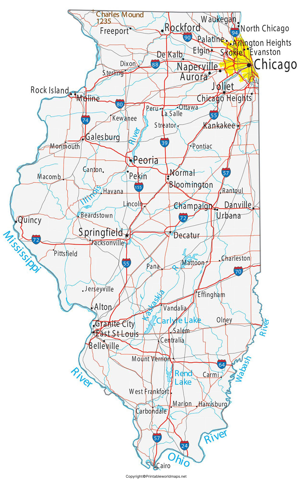
The Labeled Map of Illinois helps identify the state’s capital, major cities, counties, rivers, surrounding states, and other important geographic features. Illinois is located in the Midwestern United States and borders Wisconsin, Iowa, Missouri, Kentucky, Indiana, and Michigan. Lake Michigan forms part of its northeastern boundary, while the Mississippi River forms much of the western boundary.
Illinois is known as the Prairie State and became the 21st state of the United States on December 3, 1818. Springfield has served as the state capital since 1837.
This page provides printable Illinois maps, a map showing the state capital, major cities, geographic features, and useful facts for students, teachers, travelers, researchers, and anyone studying the geography of Illinois.
Labeled Map of Illinois
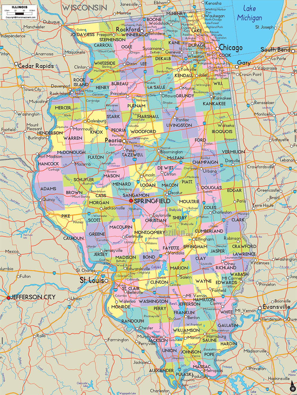
A Labeled Map of Illinois makes it easier to locate Springfield, Chicago, Rockford, Peoria, Aurora, Naperville, Joliet, Champaign, Waukegan, and other important places. Depending on the map version, additional features may include interstate highways, railroads, rivers, lakes, and county boundaries.
Illinois has a land area of about 55,513 square miles and a water area of about 2,400 square miles. The U.S. Census Bureau identifies Illinois as the 24th-largest U.S. state by total area.
The latest U.S. Census Bureau population estimate available for Illinois is 12,719,141 residents as of July 1, 2025. The 2020 Census counted 12,812,508 residents.
Illinois at a Glance
| Fact | Information |
|---|---|
| State | Illinois |
| Capital | Springfield |
| Nickname | The Prairie State |
| Statehood | December 3, 1818 |
| U.S. admission | 21st state |
| Counties | 102 |
| 2025 population estimate | 12,719,141 |
| Land area | About 55,513 sq. mi. |
| Water area | About 2,400 sq. mi. |
| Largest city | Chicago |
| State postal abbreviation | IL |
| Main geographic region | Midwest |
Illinois has 102 counties, according to the U.S. Census Bureau.
Labeled Map of Illinois Printable
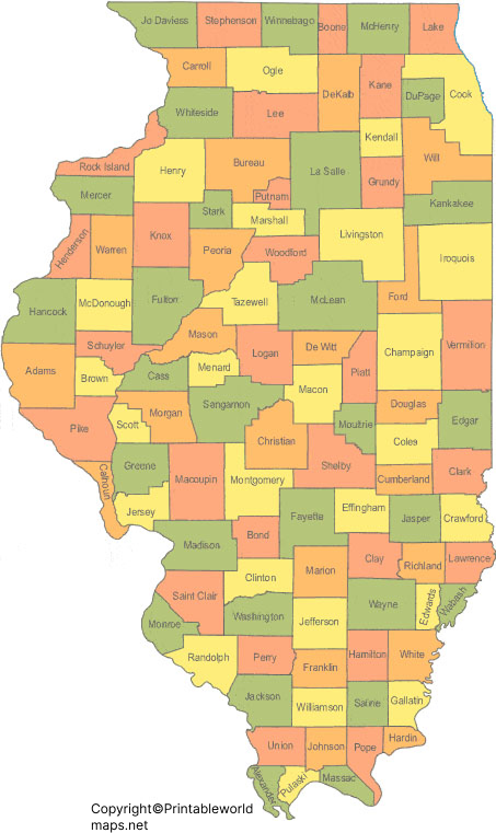
A printable Labeled Map of Illinois can be useful for classroom activities, geography assignments, state studies, travel planning, and reference work.
Illinois is divided into 102 counties. Cook County is the state’s most populous county, while Hardin County has the smallest population. The U.S. Census Bureau estimates Hardin County’s population at 3,588 in 2025.
McLean County is the largest Illinois county by land area, with approximately 1,183.25 square miles of land.
Putnam County has approximately 160.10 square miles of land, making it one of the state’s smallest counties by area.
Labeled Map of Illinois with Cities
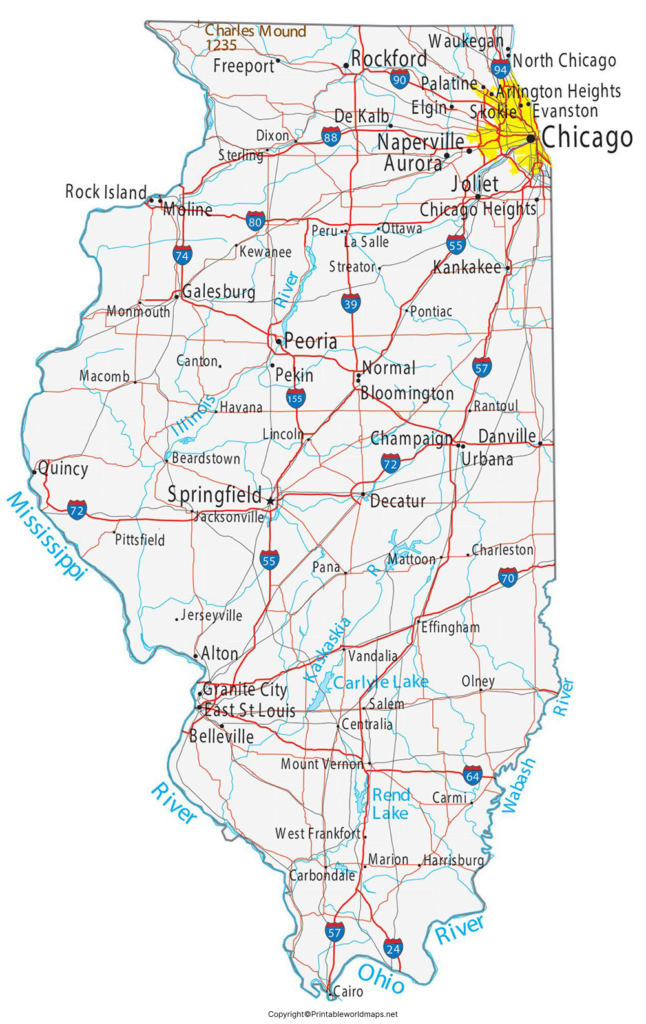
The Labeled Map of Illinois with Cities helps users locate major population centers across northern, central, and southern Illinois.
Labeled Illinois Map with Capital
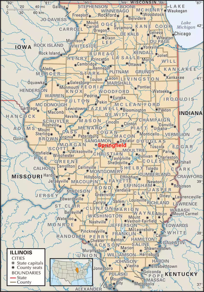
Important Illinois cities include:
- Chicago
- Aurora
- Rockford
- Joliet
- Naperville
- Springfield
- Peoria
- Elgin
- Waukegan
- Champaign
- Bloomington
- Decatur
- Evanston
- Quincy
- Rock Island
Chicago is the largest city in Illinois. The U.S. Census Bureau estimates Chicago’s population at 2,731,585 as of July 1, 2025.
The list of cities should not be interpreted as a current population ranking unless population estimates and their reference dates are specifically provided.
Major Illinois Cities to Find on the Map
Chicago
Chicago is located in northeastern Illinois on the southwestern shore of Lake Michigan. It is the state’s largest city and a major transportation, business, cultural, and population center. The 2025 Census estimate places its population at 2,731,585.
Aurora
Aurora is one of Illinois’ major cities and extends across portions of Kane, DuPage, Kendall, and Will counties. It is located west of Chicago.
Rockford
Rockford is located in northern Illinois near the Rock River and is an important regional center for manufacturing, business, education, and services.
Joliet
Joliet is located southwest of Chicago and is part of the Chicago metropolitan area. Its location near major highways and transportation routes makes it an important logistics and transportation center.
Naperville
Naperville is located west of Chicago and is primarily associated with DuPage and Will counties. It is one of the state’s major suburban communities.
Springfield
Springfield is the capital of Illinois and is located in central Illinois. The city is strongly associated with the state’s political history and Abraham Lincoln.
Peoria
Peoria is located along the Illinois River in central Illinois and serves as a regional center for business, healthcare, education, and culture.
Champaign
Champaign is located in east-central Illinois and forms the Champaign-Urbana metropolitan area with Urbana. The University of Illinois Urbana-Champaign is located in the area.
Waukegan
Waukegan is located along Lake Michigan in northeastern Illinois and is the county seat of Lake County.
Elgin
Elgin is located northwest of Chicago along the Fox River and is part of the greater Chicago metropolitan region.
Labeled Illinois Map with Capital
The capital of Illinois is Springfield. Illinois moved its capital from Vandalia to Springfield in 1837, and Springfield remains the capital today.
The current Illinois State Capitol in Springfield is the state’s sixth capitol building. The Old State Capitol served as the seat of state government from 1839 to 1876 before the current capitol was completed.
Springfield is also closely connected with the history of Abraham Lincoln. The Abraham Lincoln Presidential Library and Museum is located in Springfield, along with Lincoln’s former home and Lincoln’s Tomb at Oak Ridge Cemetery.
Illinois Borders and Neighboring States
An Illinois map is especially useful for understanding the state’s unusual combination of land and water boundaries.
Illinois borders:
- Wisconsin to the north
- Iowa across the Mississippi River to the west/northwest
- Missouri across the Mississippi River to the west
- Kentucky to the south and southeast
- Indiana to the east
- Michigan across Lake Michigan
Lake Michigan forms Illinois’ northeastern water boundary. The Mississippi River forms much of the western boundary, while the Ohio and Wabash rivers help define portions of the southern and southeastern boundaries.
Rivers and Water Features in Illinois
Illinois has an extensive network of rivers and streams. Major waterways associated with the state include the:
- Mississippi River
- Ohio River
- Wabash River
- Illinois River
- Kaskaskia River
- Rock River
- Fox River
- Little Wabash River
The Illinois Department of Natural Resources reports that Illinois has 880 miles of bordering rivers and approximately 87,110 miles of rivers and streams within the state. The Mississippi, Ohio, and Wabash rivers form important portions of Illinois’ boundaries.
The Illinois River is the second-longest river within or along Illinois’ boundaries at approximately 332 miles, while the Mississippi River forms a major western boundary.
Lake Michigan is another important geographic feature and gives northeastern Illinois access to one of North America’s Great Lakes.
Illinois Geography and Landscape
Illinois is often associated with broad prairies, agricultural land, river valleys, forests, wetlands, and urban areas.
The state’s geography changes considerably from north to south. Northern Illinois includes the Chicago metropolitan area and Lake Michigan shoreline, while central Illinois contains extensive agricultural landscapes. Southern Illinois includes more forested and hilly terrain, including areas influenced by the Shawnee region.
Illinois’ waterways are also important to understanding its geography. Most Illinois rivers ultimately drain toward the Mississippi or Ohio river systems, while a smaller northeastern portion drains toward Lake Michigan.
Illinois Counties
Illinois contains 102 counties. Cook County is the state’s largest county by population and contains Chicago.
For geographic study, county maps are useful because county boundaries help identify local governments, population centers, transportation networks, and regional differences.
McLean County has approximately 1,183.25 square miles of land and is the largest Illinois county by total area.
Illinois Population Facts
The U.S. Census Bureau estimates Illinois’ population at 12,719,141 on July 1, 2025. The 2020 Census recorded 12,812,508 residents.
Population data can change as new Census estimates are released. For that reason, population figures on maps and educational pages should always include the reference year.
Chicago remains Illinois’ largest city, with a Census Bureau population estimate of 2,731,585 in 2025.
Why Use a Labeled Map of Illinois?
A labeled state map can help with:
- Geography homework
- Classroom teaching
- State history lessons
- Identifying Illinois cities
- Locating Springfield, the state capital
- Learning Illinois county boundaries
- Understanding neighboring states
- Studying major rivers and lakes
- Planning educational projects
- Creating presentations and reports
- General geographic reference
For students, a labeled map can be especially useful when learning how physical geography and political boundaries relate to cities and counties.
Illinois Map Facts: Quick Reference
Illinois Map Facts: Quick Reference
| Category | Key Information |
|---|---|
| Capital | Springfield |
| Largest city | Chicago |
| State nickname | Prairie State |
| Statehood | December 3, 1818 |
| Counties | 102 |
| 2025 population estimate | 12,719,141 |
| 2020 Census population | 12,812,508 |
| Land area | 55,513.1 sq. mi. approximately |
| Water area | 2,400.3 sq. mi. approximately |
| Major lake | Lake Michigan |
| Major western boundary | Mississippi River |
| Major southern boundary | Ohio River |
| Major eastern boundary | Wabash River / Indiana border |
| Postal abbreviation | IL |
Frequently Asked Questions About the Labeled Map of Illinois
What is the capital of Illinois?
Springfield is the capital of Illinois. The state capital was moved from Vandalia to Springfield in 1837.
What is the largest city in Illinois?
Chicago is the largest city in Illinois by population. The U.S. Census Bureau estimated Chicago’s population at 2,731,585 on July 1, 2025.
How many counties are in Illinois?
Illinois has 102 counties.
What states border Illinois?
Illinois borders Wisconsin, Iowa, Missouri, Kentucky, Indiana, and Michigan. Lake Michigan also forms part of the state’s northeastern boundary.
Why is Illinois called the Prairie State?
Illinois is officially known as the Prairie State, reflecting the extensive prairie landscapes that historically characterized much of the state. Illinois state resources identify Prairie State as the state’s nickname.
What rivers are shown on an Illinois map?
Major rivers associated with Illinois include the Mississippi, Ohio, Wabash, Illinois, Kaskaskia, Rock, and Fox rivers.
Where is Springfield located?
Springfield is located in central Illinois and serves as the state capital. It is also an important location for Illinois political and Abraham Lincoln history.
What is the population of Illinois?
The U.S. Census Bureau estimated Illinois’ population at 12,719,141 on July 1, 2025.
Can I print the Illinois map?
Yes. The image and PDF versions provided on this page can be used as printable geographic references. Always check the individual map’s stated source, date, and intended use before publishing or redistributing it.
What can students learn from a labeled Illinois map?
Students can use the map to identify the state capital, major cities, neighboring states, counties, rivers, Lake Michigan, and other geographic features. It can also support state geography and history assignments.
Reference Links
https://data.census.gov/profile/Illinois?g=040XX00US17
https://www.census.gov/quickfacts/fact/table/IL/LFE041223
https://www.illinois.gov/about/fun-facts.html
https://dnr.illinois.gov/education/atoz/ilriversstreams.html
https://presidentlincoln.illinois.gov
https://pubs.usgs.gov/publication/sir20235064B/full
https://dnrhistoric.illinois.gov/experience/sites/central/old-capitol.html









