

Explore the South America Rivers Map to identify major rivers, understand drainage patterns, and learn about the continent’s physical geography. This page provides printable river maps, labeled maps, and PDF downloads for students, teachers, geography enthusiasts, and anyone preparing a school project.
South America has three major river systems: the Amazon, Orinoco, and Paraguay–Paraná basins. These river systems support rainforests, wetlands, agricultural regions, wildlife habitats, and communities across the continent.
Use the maps below to locate important rivers, trace their general courses, and improve your understanding of South American geography.
South America Rivers Map
View the South America rivers map to explore the locations of major waterways and their surrounding geographical regions.
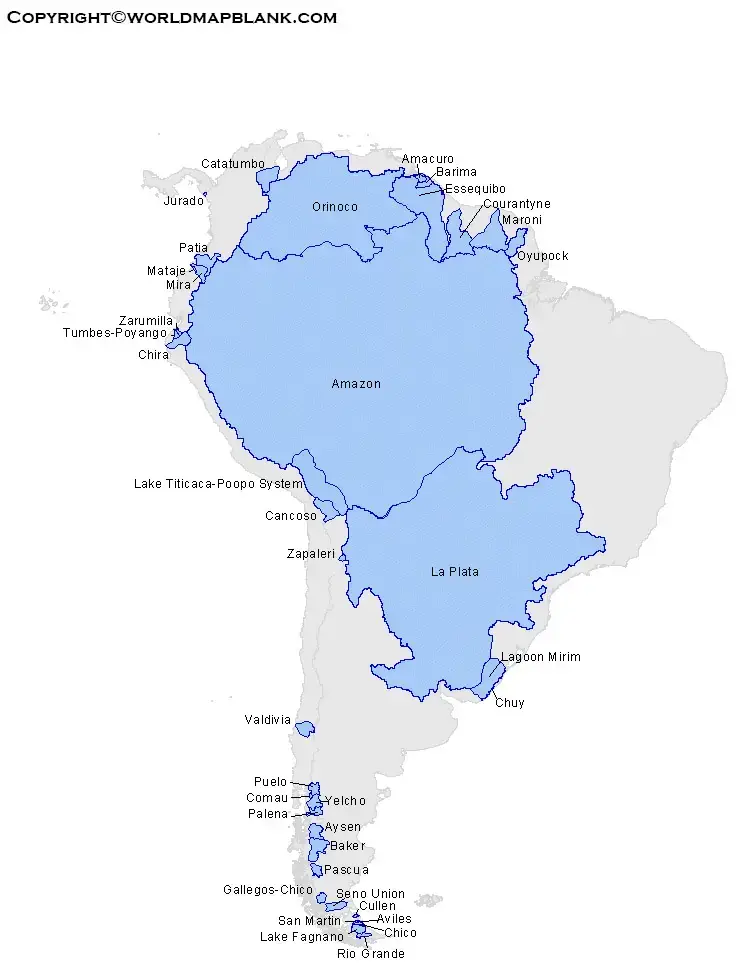
A river map is useful for understanding how waterways connect inland areas with the Atlantic Ocean and other coastal outlets. The Amazon system drains much of northern South America, while the Orinoco drains large areas of Venezuela and Colombia. The Paraná and Paraguay rivers form part of an extensive drainage system in the south-central and southeastern regions.
Printable South America Rivers Map
A printable South America rivers map is useful for classroom activities, geography lessons, revision, and map-labeling exercises. Students can use a blank or labeled map to locate major rivers, identify neighboring countries, and study where river systems flow.

For the best results, print the map at a size that keeps river names and labels readable. If the map is used for an assignment, check the labels against a reliable geographical reference.
Map of South America Rivers
The map of South America rivers helps readers understand the relationship between mountains, lowlands, river basins, and coastlines. Many major rivers receive water from tributaries, rainfall, and, in some areas, mountain snow and ice.

When studying a river map, look for the river’s source, the direction of its flow, major tributaries, and its mouth or final outlet. Not every map includes all these details, so consult the map legend and labels before drawing conclusions.
Map of South America Rivers Labeled
A labeled South America rivers map makes it easier to identify important waterways without having to guess their locations. It can support geography homework, classroom demonstrations, revision exercises, and independent learning.

To practise, locate the Amazon, Orinoco, Paraná, Paraguay, São Francisco, and Uruguay rivers. Then identify the countries and geographical regions associated with each river. Use a separate political map if you need to verify national borders.
Major Rivers of South America
South America has many rivers, but several stand out because of their size, drainage areas, ecological importance, and role in transportation and agriculture.
1. Amazon River
The Amazon River is the central waterway of the Amazon Basin and carries an exceptionally large volume of freshwater into the Atlantic Ocean. Its basin extends across several South American countries and supports extensive tropical rainforest and freshwater ecosystems.
2. Orinoco River
The Orinoco flows through Venezuela and along parts of the Colombia–Venezuela region before reaching the Atlantic Ocean. Its basin includes the Llanos, a vast tropical grassland region with seasonal flooding.
3. Paraná River
The Paraná is one of the major rivers of south-central South America. It flows through or along parts of Brazil, Paraguay, and Argentina and forms part of the wider Río de la Plata drainage system.
4. Paraguay River
The Paraguay River is an important tributary of the Paraná. It flows through Brazil, Bolivia’s border region, Paraguay, and Argentina’s wider drainage region, connecting extensive wetlands and lowland landscapes.
5. São Francisco River
The São Francisco flows entirely within Brazil. It is important for water supply, irrigation, hydropower, and communities in several regions of the country.
6. Uruguay River
The Uruguay River forms parts of the boundaries between Brazil, Argentina, and Uruguay. It eventually joins the Paraná system through the Río de la Plata estuary.
7. Magdalena River
The Magdalena is one of Colombia’s most important rivers. It flows northward through the country toward the Caribbean Sea and has played a major role in transportation, settlement, and economic activity.
Three Major River Basins of South America
Understanding river basins makes a rivers map more useful because a basin includes the main river and the land drained by its tributaries.
- Amazon Basin: The largest drainage basin on the continent, covering extensive areas of northern South America.
- Orinoco Basin: Drains much of Venezuela and parts of Colombia, including important tropical grassland and wetland environments.
- Paraguay–Paraná Basin: Drains large parts of south-central South America and connects with the Río de la Plata estuary.
These basins differ in climate, terrain, vegetation, and seasonal water levels. Their rivers influence ecosystems, farming, navigation, settlements, and freshwater availability.
Interesting Facts About South American Rivers
- The Amazon Basin is enormous. It is widely recognized as the world’s largest river drainage basin.
- The Amazon discharges into the Atlantic Ocean. Its vast network of tributaries drains a large portion of northern South America.
- The Orinoco supports the Llanos. Seasonal flooding influences the grasslands and wetlands of Venezuela and Colombia.
- The Paraná connects major waterways. It forms part of the wider Paraguay–Paraná river system and drains toward the Río de la Plata.
- The São Francisco remains within Brazil. It is a major river for water supply, irrigation, and hydropower.
- The Magdalena is vital to Colombia. Its valley has long supported settlement and transport.
- River levels change seasonally. Rainfall patterns, terrain, and climate influence flooding and water availability in different basins.
How to Use a South America Rivers Map for Learning
Follow these steps to get more value from a printable or digital map:
- Locate the Andes Mountains and identify rivers that begin in or near the mountain region.
- Trace the Amazon River eastward toward the Atlantic Ocean.
- Find the Orinoco River in northern South America.
- Locate the Paraná and Paraguay rivers in the south-central part of the continent.
- Identify the São Francisco River in eastern Brazil and the Magdalena River in Colombia.
- Use a political map to check the countries through which each river flows.
- Label the rivers on a blank map to test your geographical knowledge.
For schoolwork, confirm spellings, tributaries, and river courses using an atlas or an authoritative geographical source.
Frequently Asked Questions
What is the largest river basin in South America?
The Amazon Basin is the largest river drainage basin in South America and is widely recognized as the largest in the world.
Which are the three major river basins of South America?
The Amazon, Orinoco, and Paraguay–Paraná basins are three of the continent’s principal river systems.
Which ocean does the Amazon River flow into?
The Amazon River flows into the Atlantic Ocean along the northern coast of Brazil.
Which countries does the Orinoco River drain?
The Orinoco Basin extends across Venezuela and Colombia, with the majority of the basin in Venezuela.
What is a labeled South America rivers map used for?
A labeled map helps students identify rivers, learn their locations, understand drainage patterns, and complete geography assignments.
Can I download a South America rivers map as a PDF?
Yes. The PDF links provided above can be used to access the available printable maps. Check the file before printing to ensure the labels and map details suit your needs.
How can I learn the rivers of South America quickly?
Start with the Amazon, Orinoco, and Paraná–Paraguay systems. Then locate the São Francisco, Uruguay, and Magdalena rivers on a labeled map and practise marking them on a blank version.
Reference links
https://education.nationalgeographic.org/resource/south-america-physical-geography
https://www.nationalgeographic.org/explore/programs/perpetual-planet/expedition-amazon
https://media.nationalgeographic.org/assets/reference/assets/south-america-physical-geography-4.pdf
https://www.nationalgeographic.com/travel/world-heritage/article/central-amazon
