
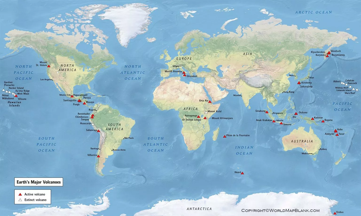

Map of Active Volcanoes in the World is a useful geographic resource for locating volcanoes with known Holocene eruptive activity and understanding the global distribution of volcanic regions. This page provides a map of active volcanoes in the world, printable map resources, PDF versions, and factual information about volcanic activity.
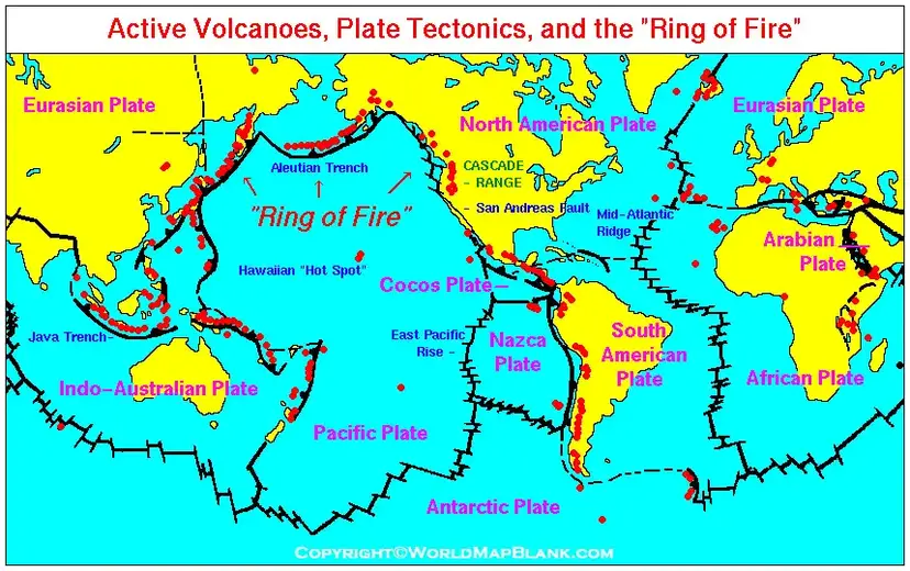
Volcanoes are not distributed randomly across Earth. Many occur around tectonic plate boundaries, while others develop within plates, such as volcanic systems associated with hotspots. More than half of the world’s active volcanoes above sea level are located around the Pacific Ocean in the region commonly known as the Ring of Fire.
The term “active volcano” also needs some clarification. There is no single worldwide definition. The Smithsonian Global Volcanism Program explains that the answer depends on the time period being considered and the criteria used. Its database currently records 1,214 volcanoes with eruptions during the Holocene, approximately the last 12,000 years.
Map of Active Volcanoes in the World
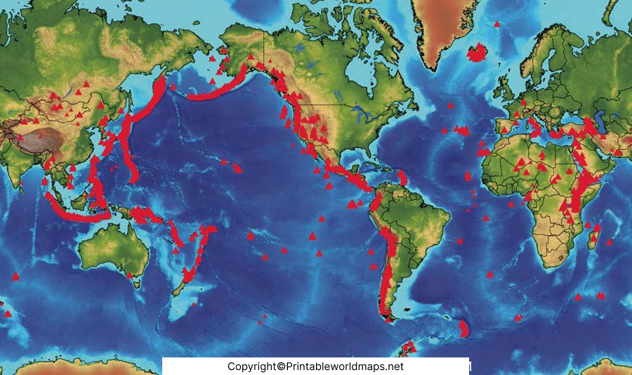
The Map of Active Volcanoes in the World provides a visual overview of volcanic locations across different continents and regions. It can be useful for geography lessons, classroom assignments, research, presentations, and general reference.
Volcanoes form through different geological processes. Many are associated with areas where tectonic plates converge or diverge, while others occur away from plate boundaries. The location and type of volcanic activity vary considerably from one volcanic system to another.
What Does “Active Volcano” Mean?
The phrase active volcano does not necessarily mean that a volcano is erupting today.
For example, the Smithsonian Global Volcanism Program uses Holocene activity as one important way of organizing volcanoes. Its database includes volcanoes that have erupted during the Holocene, a geological period covering approximately the last 12,000 years.
USGS assessments can also use a Holocene-based definition of active volcanoes, while considering additional evidence such as earthquakes, ground deformation, and gas emissions when assessing volcanic unrest.
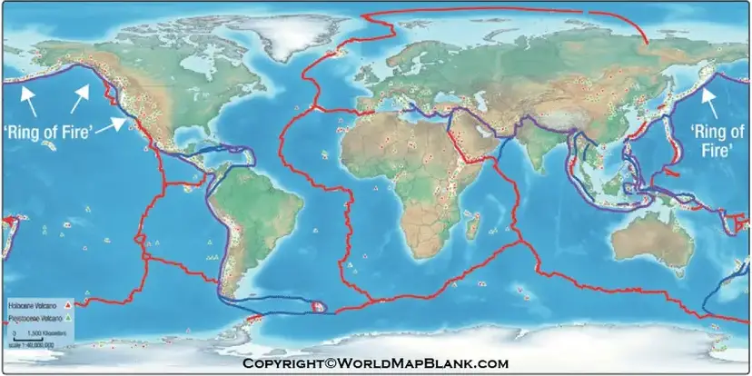
Active Volcanoes in the World
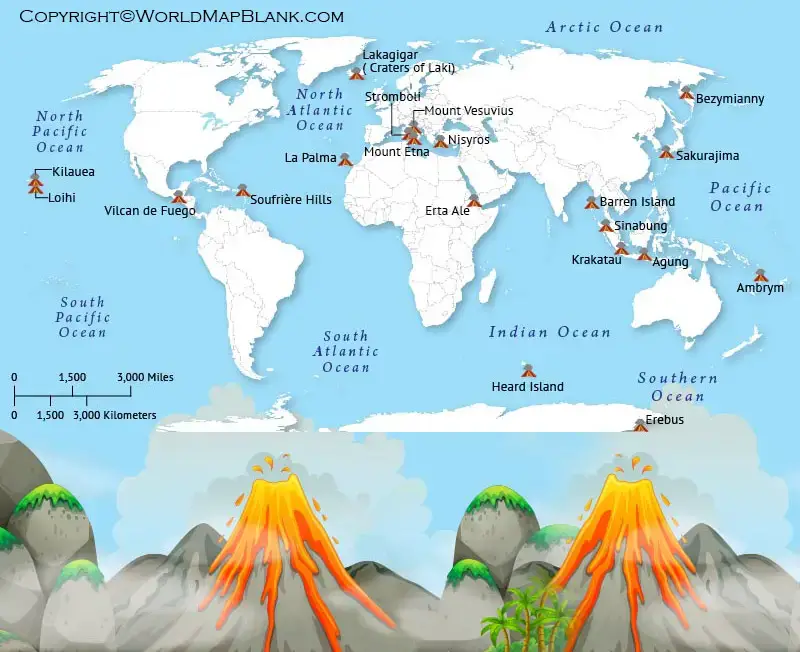
The world’s volcanoes are concentrated in several major geological regions. A particularly important area is the Pacific Ring of Fire, where numerous volcanic systems occur around the margins of the Pacific Ocean. USGS notes that more than half of the world’s active volcanoes above sea level encircle the Pacific.
However, volcanic activity is not limited to the Pacific. Holocene volcanoes are recorded across 78 countries plus Antarctica in the Smithsonian Global Volcanism Program database.
Some well-known volcanic regions include:
- Pacific Ring of Fire
- Japan and the Kuril Islands
- Indonesia
- New Zealand
- Iceland
- Mediterranean volcanic regions
- East African Rift
- Central and South America
- Hawaii
- Antarctica
The distribution of volcanoes provides an excellent example of how Earth’s internal processes influence surface geography.
Active Volcanoes Map
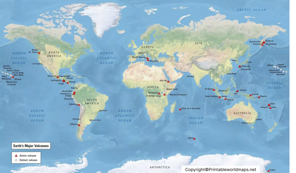
The Active Volcanoes Map can help students and researchers visualize the geographic distribution of volcanoes around the world.
A map is particularly useful when studying the relationship between volcanoes and tectonic plates. Many volcanoes occur near plate boundaries, where plates collide, separate, or interact with Earth’s mantle. However, volcanic activity can also occur away from plate boundaries.
For safety-related decisions, however, a static map should not replace official monitoring information. Scientists monitor volcanoes using methods such as earthquake measurements, ground deformation, gas observations, field observations, and satellite data. USGS explains that monitoring can identify changes in volcanic behavior, although scientists cannot generally predict the exact time and location of an eruption.
Printable Map of Active Volcanoes in the World
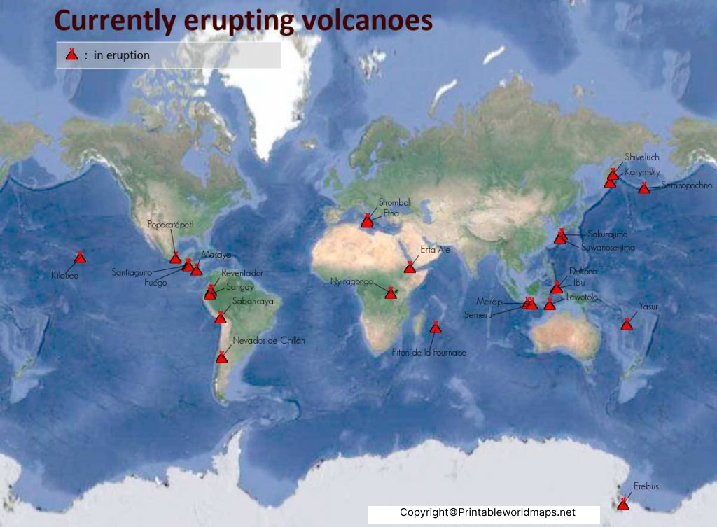
A Printable Map of Active Volcanoes in the World can be useful for classroom activities, geography projects, research notes, presentations, and personal study.
The PDF format is convenient when you want to:
- Print a world volcano map for classroom use
- Mark individual volcanic regions
- Compare volcano locations with continents
- Study the Pacific Ring of Fire
- Use the map in geography assignments
- Add notes about volcanic regions
- Keep a printable reference for offline study
The map should be considered a geographic reference, rather than a real-time volcanic alert map. Volcano status can change, and official monitoring agencies should be consulted for current activity.
How Many Active Volcanoes Are There in the World?
There is no single number that represents every definition of an “active volcano.”
According to the Smithsonian Global Volcanism Program’s 2026 database, there are 1,214 volcanoes with eruptions during the Holocene. The same database records 522 volcanoes with confirmed eruptions since 1800 and 333 with confirmed eruptions since 1960.
For current eruption statistics, the Smithsonian reported 47 eruptions in progress or recorded during 2026 through its March 31, 2026 data update, while noting that these statistics are subject to updates and corrections.
This is why statements such as “there are exactly X active volcanoes in the world” should be used carefully.
Where Are Most Active Volcanoes Located?
The Pacific Ring of Fire is one of the world’s most significant volcanic regions. It follows much of the Pacific Ocean’s margins and includes numerous volcanic arcs and tectonic boundaries. USGS states that more than half of the world’s active volcanoes above sea level are located around the Pacific.
Other important volcanic areas include parts of:
- Indonesia
- Japan
- New Zealand
- Iceland
- Italy
- Central America
- South America
- East Africa
- Antarctica
The Smithsonian database records Holocene volcanoes in 78 countries plus Antarctica, demonstrating that volcanic activity occurs across a wide geographic range.
How Scientists Monitor Active Volcanoes
Modern volcano monitoring uses several types of scientific observations.
Scientists can monitor:
- Earthquakes and volcanic tremors
- Ground deformation
- Volcanic gases
- Thermal changes
- Lava movement
- Ash plumes
- Satellite imagery
- Changes around volcanic vents
Satellite observations are particularly important for remote volcanoes. NOAA explains that satellites can monitor volcanic ash and gases such as sulfur dioxide and can observe volcanic activity over isolated areas.
Why Use a World Volcano Map?
A world volcano map can make complex geological information easier to understand visually.
For Students
Students can use the map to study:
- Earth’s physical geography
- Tectonic plates
- Volcano distribution
- The Pacific Ring of Fire
- Continental geography
- Volcanic regions
For Teachers
Teachers can use printable maps for:
- Geography worksheets
- Classroom demonstrations
- Map-labeling exercises
- Science projects
- Volcano lessons
- Research assignments
Volcano Hazards
Volcanoes can produce several different hazards depending on the type and scale of an eruption.
Potential hazards include:
- Lava flows
- Volcanic ash
- Pyroclastic flows
- Lahars
- Volcanic gases
- Rockfalls
- Explosive eruptions
- Ash clouds affecting aviation
USGS identifies volcanic eruptions as sources of multiple geological and hydrological hazards.
Volcanic ash can also affect aviation, infrastructure, health, and economic activity. NOAA notes that satellite monitoring plays an important role in tracking ash and volcanic gases.
Interesting Facts About Active Volcanoes
Here are several useful facts for geography and science readers:
- The Smithsonian Global Volcanism Program currently lists 1,214 Holocene volcanoes.
- Holocene volcanoes in the Smithsonian database occur in 78 countries plus Antarctica.
- More than half of the world’s active volcanoes above sea level are associated with the Pacific Ring of Fire.
- Volcanoes can occur both at tectonic plate boundaries and within plates.
- Scientists use earthquakes, ground deformation, gases, satellite observations, and other measurements to monitor volcanic systems.
- The Volcanic Explosivity Index, or VEI, is used to describe the explosiveness of explosive eruptions on a scale from 0 to 8.
- Satellite technology is especially useful for observing remote volcanic regions and volcanic ash.
How to Use the Map of Active Volcanoes in the World
You can use the Map of Active Volcanoes in the World for educational and geographic reference purposes.
A simple activity is to identify a volcano on the map, locate the surrounding country or region, and then compare its location with tectonic plate boundaries. You can also use the Smithsonian Global Volcanism Program to investigate its eruption history and scientific information.
For current eruption information, always check the latest reports from the relevant national volcano observatory or recognized scientific monitoring organization.
Frequently Asked Questions
What is a map of active volcanoes in the world?
A map of active volcanoes in the world shows the geographic distribution of volcanoes that meet a particular definition of volcanic activity. Definitions vary, so a map should identify its underlying data source and criteria.
How many active volcanoes are there in the world?
There is no single universally accepted number because “active” can be defined using different time periods and criteria. The Smithsonian Global Volcanism Program currently lists 1,214 volcanoes with Holocene eruptions in its database.
What is the Ring of Fire?
The Pacific Ring of Fire is a broad zone surrounding much of the Pacific Ocean where numerous volcanoes and tectonic features occur. More than half of the world’s active volcanoes above sea level are located in this region.
Can an active volcano be dormant?
Yes. “Active” does not necessarily mean that a volcano is erupting at this moment. A volcano may have evidence of relatively recent geological activity while remaining quiet for long periods.
Can a world volcano map show live eruptions?
A static printable map cannot reliably provide live eruption information. For current activity, use updated information from official volcano observatories, the Smithsonian Global Volcanism Program, USGS, or other recognized monitoring agencies.
What are the main hazards of volcanic eruptions?
Depending on the volcano and eruption, hazards can include lava flows, ashfall, pyroclastic flows, lahars, volcanic gases, rockfalls, and impacts on aviation.
How do scientists monitor volcanoes?
Scientists use seismic measurements, ground deformation, volcanic gas measurements, field observations, thermal information, satellite imagery, and other techniques to detect changes in volcanic behavior.
Is the printable active volcano map useful for students?
Yes. A printable map can be used for geography assignments, science projects, classroom activities, map-labeling exercises, and research preparation.
Where can I find reliable volcano data?
The Smithsonian Global Volcanism Program provides a major global database of volcanoes and eruptions. USGS and national volcano observatories also provide monitoring and hazard information.
Reference Links
https://volcano.si.edu/volcanolist_holocene.cfm
https://volcano.si.edu/gvp_currenteruptions.cfm
https://volcano.si.edu/volcanolist_countries.cfm
https://pubs.usgs.gov/gip/monitor/intro.html
https://www.usgs.gov/publications/what-are-volcano-hazards
https://www.usgs.gov/media/audio/what-ring-fire
https://www.nesdis.noaa.gov/our-environment/dust-ash-fire/ash
