

A labeled map of Nevada helps you locate the state capital, major cities, county boundaries, rivers, highways, and neighboring states. Nevada is in the western United States and shares borders with California, Oregon, Idaho, Utah, and Arizona. Its capital is Carson City, while Las Vegas is its best-known major city.
Whether you are studying U.S. geography, preparing a school project, planning a trip, or looking for a printable reference, these labeled Nevada maps can help you identify important places quickly.
Labeled Map of Nevada
A labeled map of Nevada provides a visual overview of the state’s location, boundaries, capital, cities, and major geographic features. Depending on the map, it may also show roads, rivers, lakes, and other reference points.
Nevada is the seventh-largest U.S. state by land area, covering approximately 109,800 square miles (284,000 square kilometers). It became the 36th state on October 31, 1864. Its geography includes extensive desert basins, mountain ranges, and valleys.
For current demographic information, consult the U.S. Census Bureau’s Nevada QuickFacts.
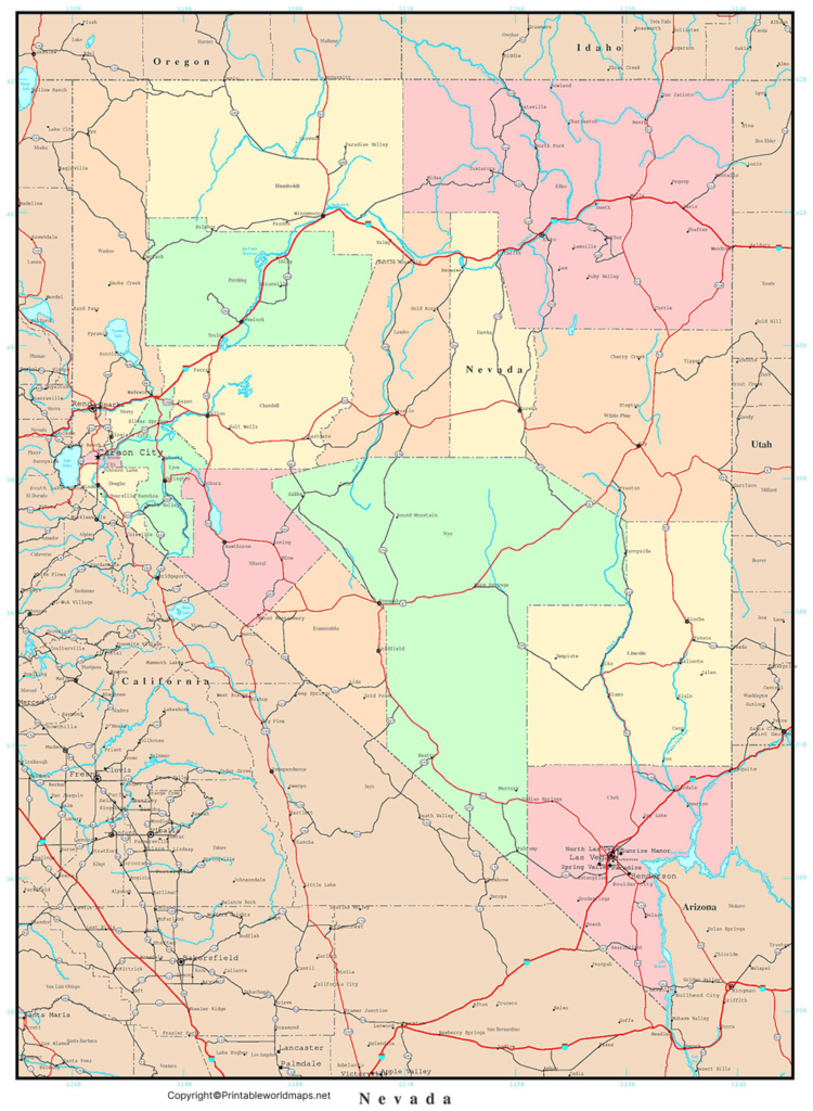
Printable Map of Nevada Labeled
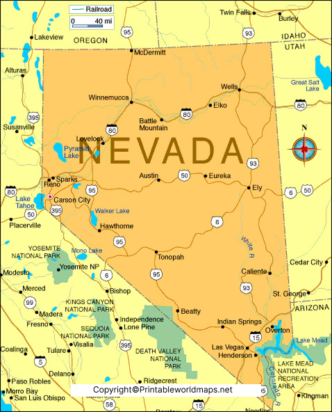
A printable Nevada map is useful for classroom activities, geography lessons, travel preparation, and personal reference. A high-resolution image works well for viewing on a screen, while a PDF is generally convenient for printing.
Before printing, check the map’s labels and legend to confirm which features are included. A basic outline map may show only state boundaries, while a more detailed map may identify cities, counties, highways, and physical features.
Printing tip: Use landscape or portrait orientation according to the map’s proportions. Select “Fit to page” to reduce the risk of cutting off the state boundaries or labels.
Labeled Map of Nevada with Cities
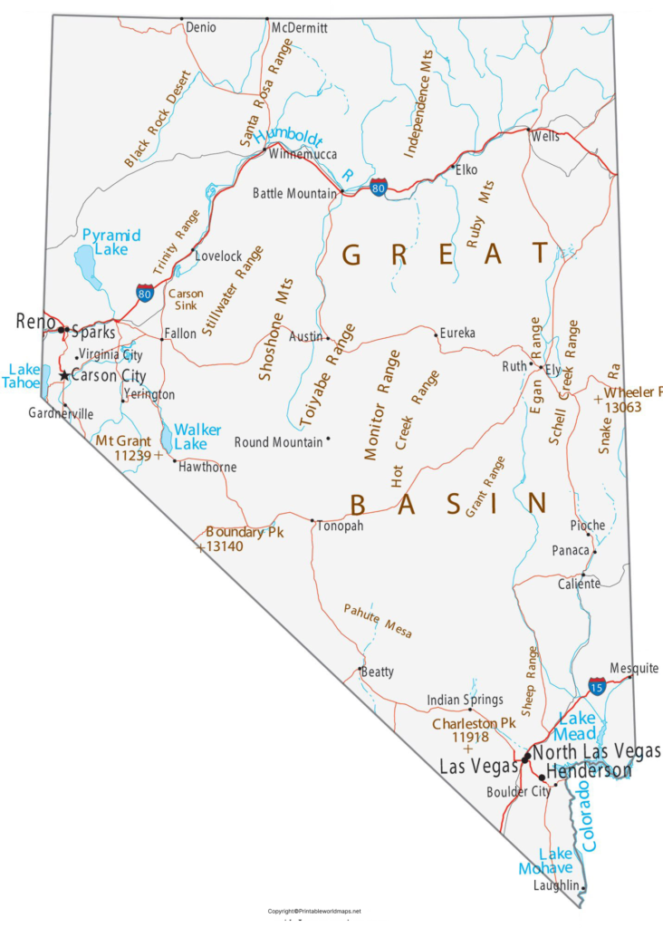
A labeled map of Nevada with cities helps readers understand where major urban areas are located across the state. Important cities and urban communities include:
- Las Vegas: A major population, tourism, and entertainment center in southern Nevada.
- Henderson: A large city southeast of Las Vegas.
- North Las Vegas: An incorporated city within the Las Vegas metropolitan area.
- Reno: A major city in western Nevada, near the California border.
- Sparks: A city adjoining Reno in the Reno–Sparks urban area.
- Carson City: Nevada’s state capital, west of the central part of the state.
- Elko: An important northeastern Nevada community and regional service center.
- Mesquite: A city in southeastern Nevada near the Arizona and Utah region.
City population figures change over time, and population rankings depend on the year and whether city limits or metropolitan areas are being compared. For reliable, current figures, use the U.S. Census Bureau’s city and state population data.
Labeled Nevada Map with Capital
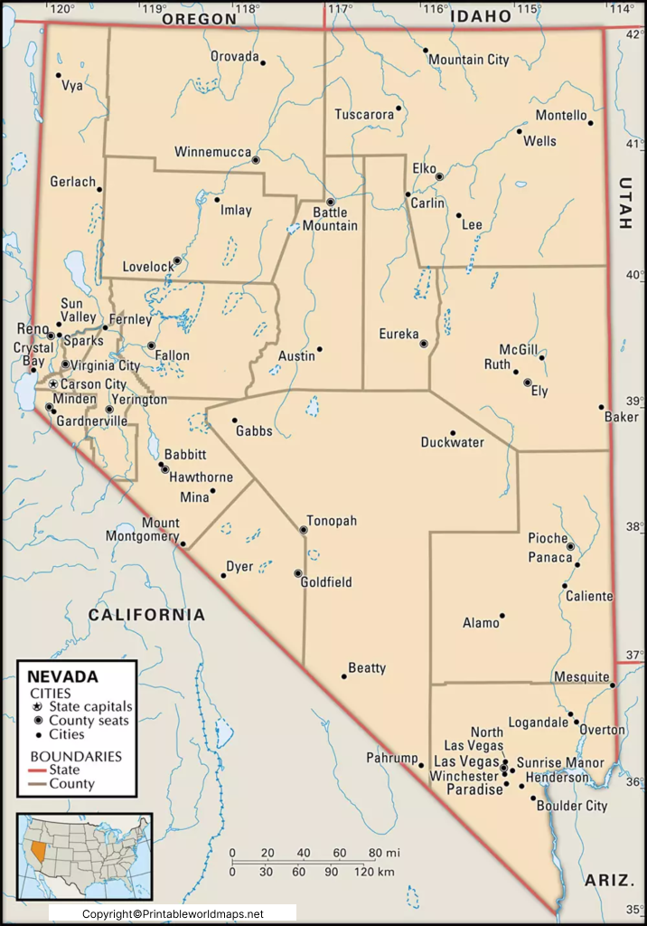
Carson City is the capital of Nevada. It is an independent city that also functions as a county-equivalent for administrative and census purposes. The city was named after the frontiersman Kit Carson and has served as Nevada’s capital since the state entered the Union in 1864.
Carson City is home to important state government institutions, including the Nevada State Capitol and the Nevada Legislature. Visitors can also explore local museums and learn about the state’s mining, railroad, and settlement history.
When reading a labeled Nevada map, look for the capital symbol or label to distinguish Carson City from larger population centers such as Las Vegas and Reno. The largest city is not necessarily the state capital.
For additional information, visit the official Carson City website.
Nevada Bordering States and Location
Nevada shares boundaries with five states:
- Oregon: North and northwest.
- Idaho: Northeast.
- Utah: East.
- Arizona: Southeast, with the Colorado River forming part of the boundary.
- California: West and southwest.
A state-boundary map is particularly useful for understanding Nevada’s location between the Pacific Coast region and the interior western United States.
Nevada is landlocked, meaning it has no coastline on an ocean. However, the state contains lakes and reservoirs, including parts of Lake Tahoe and Lake Mead.
Nevada Counties and Carson City
Nevada has 16 counties and the independent city of Carson City, which serves as a county-equivalent government. County boundaries help explain local administration, elections, public services, and regional geography.
Nye County is the state’s largest county by land area. Esmeralda County is among the least populous counties, so it should not be described as Nevada’s most populous county.
A county-labeled map can help students and researchers identify the boundaries of Clark, Washoe, Nye, Elko, Lincoln, and other counties. For official county information and state history, consult the Nevada state government’s history page.
Major Rivers and Geographic Features of Nevada
Nevada’s physical geography includes mountain ranges, desert basins, valleys, rivers, and reservoirs. Important water features include:
- Colorado River: Runs along part of Nevada’s southeastern boundary and is associated with Lake Mead.
- Truckee River: Flows through the Reno area and toward Pyramid Lake.
- Humboldt River: Crosses northern Nevada and is an important regional river system.
- Walker River: Flows through parts of western Nevada.
The state also contains portions of Lake Tahoe, a large alpine lake on the California–Nevada border. These features help explain the variation in elevation, climate, settlement, and transportation across Nevada.
Not every labeled map includes rivers or physical features. Check the map legend before using it for detailed physical geography.
Nevada’s History and Statehood
Nevada became the 36th state of the United States on October 31, 1864, during the American Civil War. President Abraham Lincoln issued the proclamation admitting Nevada to the Union.
The state’s history is closely associated with mining, including the Comstock Lode silver discovery in 1859. Mining contributed to the growth of early settlements and helped shape the development of transportation and communities throughout the region.
The name Nevada comes from Spanish and is associated with the meaning “snow-covered” or “snowy,” a reference to the region’s mountains.
For primary historical information, see the Nevada Legislature’s state constitution and admission documents.
How to Use a Labeled Map of Nevada
A labeled map of Nevada can support several practical activities:
- School projects: Identify the state capital, bordering states, and major cities.
- Geography practice: Compare city locations with rivers, mountain ranges, and county boundaries.
- Travel planning: Understand the relative positions of Las Vegas, Reno, Carson City, and other destinations.
- Research: Use county and city labels as a starting point for finding official government or census information.
- Printable worksheets: Use a map as a reference for labeling exercises and classroom quizzes.
For navigation, road conditions, or current travel routes, use an up-to-date mapping service rather than relying on a static printable map.
Frequently Asked Questions About Nevada Maps
What is the capital of Nevada?
Carson City is the capital of Nevada. It has served as the state capital since Nevada became a state in 1864.
What is the largest city in Nevada?
Las Vegas is Nevada’s largest incorporated city by population. Population estimates change over time, so consult the U.S. Census Bureau for the latest figures.
How many counties are in Nevada?
Nevada has 16 counties and the independent city of Carson City, which functions as a county-equivalent government.
Which states border Nevada?
Nevada borders California, Oregon, Idaho, Utah, and Arizona.
Can I print a labeled map of Nevada?
Yes. You can view the map images and use the linked PDF versions provided above. Check the PDF’s page layout and print settings before printing.
Which rivers are shown on a Nevada map?
Depending on the map, major rivers may include the Colorado River, Truckee River, Humboldt River, and Walker River.
When did Nevada become a state?
Nevada became the 36th U.S. state on October 31, 1864.
Where can I find reliable Nevada population statistics?
The U.S. Census Bureau publishes official census counts and population estimates through its Nevada QuickFacts page and other population data resources.
Reference links
https://www.census.gov/quickfacts/NV
https://www.census.gov/quickfacts
https://www.carsoncity.gov/our-city/city-facts
https://jic.nv.gov/About/History_of_Nevada
