

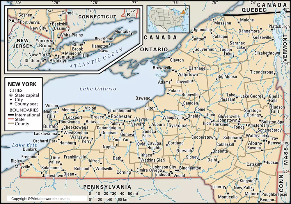
A labeled map of New York helps you locate the state capital, major cities, county boundaries, rivers, lakes, and neighboring states. Located in the northeastern United States, New York stretches from the Atlantic coast and New York City region to the Great Lakes and the Canadian border.
Whether you are a student studying U.S. geography, a teacher preparing classroom materials, or a traveler planning a trip, these labeled New York maps make it easier to understand the state’s location and geography.
Use the maps below to identify Albany, New York City, Buffalo, Rochester, Syracuse, and other important places. Printable PDF versions are also available for offline study and reference.
Labeled Map of New York
A labeled map of New York shows the state’s overall shape, surrounding states, major waterways, and important geographic locations. New York borders Pennsylvania, New Jersey, Connecticut, Massachusetts, and Vermont. It also shares international boundaries with the Canadian provinces of Ontario and Quebec.
New York is commonly known as the Empire State. According to the U.S. Census Bureau, its land area is approximately 47,123 square miles, while its total area, including water, is larger.
The state has a varied landscape, including the Adirondack Mountains, the Catskill Mountains, the Hudson River Valley, the Great Lakes shoreline, and the Atlantic coastal region. Its major waterways include the Hudson River, St. Lawrence River, Mohawk River, Delaware River, and Susquehanna River.
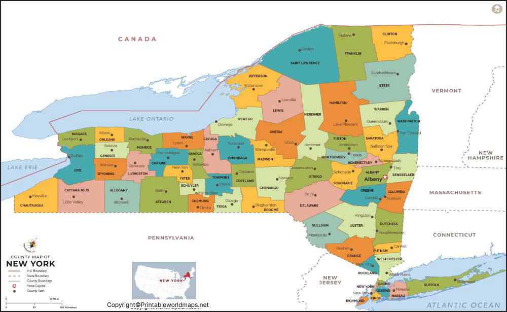
Printable New York Map Labeled
A printable New York map labeled with counties is useful for learning about the state’s administrative divisions and geographic regions. New York has 62 counties, including the five counties that correspond to New York City’s five boroughs: the Bronx, Kings (Brooklyn), New York (Manhattan), Queens, and Richmond (Staten Island).
St. Lawrence County, in northern New York, is the state’s largest county by land area. Its location along the St. Lawrence River and the Canadian border makes it an important geographic feature to identify on a county map.
A county-labeled map can help students compare locations, understand regional boundaries, and identify counties near major cities. It is also useful for classroom assignments, geography projects, and general reference.
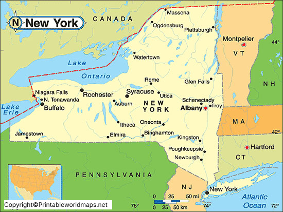
Labeled Map of New York with Cities
A labeled map of New York with cities helps you distinguish major urban centers across the state. New York City is the state’s largest city and a major international center for business, culture, transportation, and tourism.
Other important cities include Buffalo, Rochester, Syracuse, Albany, Yonkers, and Utica. Each serves a different regional role, from commerce and education to government and manufacturing.
- New York City: Located in southeastern New York, it is known for Times Square, Central Park, and its global cultural influence.
- Buffalo: Situated near Lake Erie and the Canadian border, Buffalo is a major city in western New York.
- Rochester: Located in the Finger Lakes region, Rochester is known for its educational institutions and historical connections to imaging and manufacturing.
- Syracuse: Situated in central New York, Syracuse is an important regional center for education, healthcare, and transportation.
- Albany: Located along the Hudson River, Albany is the state capital and the seat of New York’s state government.
Use the map to compare the cities’ locations and understand how New York’s population centers are distributed across the state.
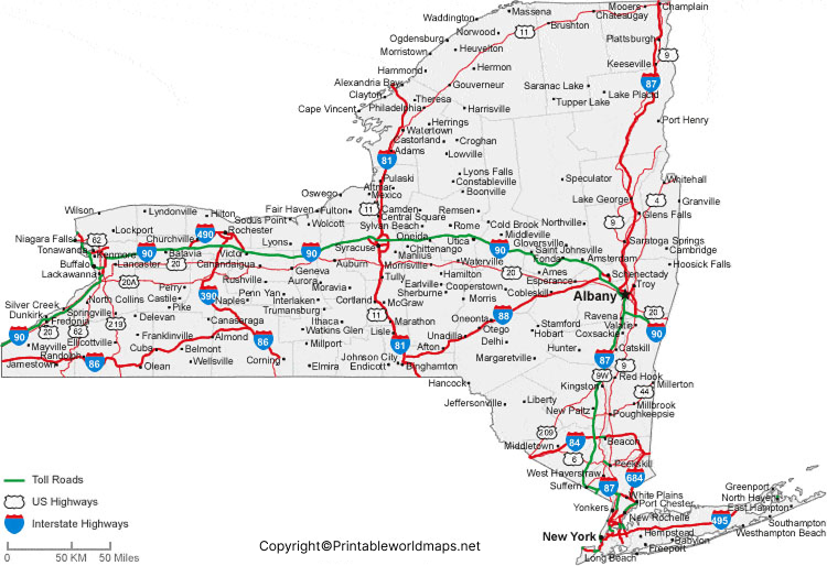
Labeled New York Map with Capital
Albany is the capital of New York State. It is located in eastern New York, on the west bank of the Hudson River, near the point where the Mohawk River joins the Hudson.
Albany serves as the center of New York’s state government and has a long history dating back to the Dutch colonial period. Today, it is recognized for its historic architecture, educational institutions, cultural attractions, and government buildings.
Notable attractions include the Empire State Plaza, The Egg performing arts center, the New York State Museum, and the Albany Institute of History & Art.
A New York map with the capital marked helps students distinguish Albany from New York City, which is the state’s largest city but not its capital. This is one of the most important distinctions to remember when studying U.S. state geography.
New York Geography: Important Facts to Know
The following facts provide additional context when reading a labeled map of New York.
| Geographic fact | Details |
|---|---|
| State capital | Albany |
| Largest city | New York City |
| State nickname | The Empire State |
| Number of counties | 62 |
| Land area | Approximately 47,123 square miles |
| Major waterways | Hudson River, St. Lawrence River, Mohawk River, Delaware River, and Susquehanna River |
| Great Lakes bordering the state | Lake Erie and Lake Ontario |
| International neighbor | Canada, including Ontario and Quebec |
| Statehood | July 26, 1788; New York became the 11th state |
Sources: U.S. Census Bureau and official New York State resources.
How to Use a Printable New York Map
A printable map can be used for schoolwork, geography practice, travel planning, and general reference.
- Choose the right map: Use a city-labeled map to study urban centers, a county map to explore administrative boundaries, or a capital map to locate Albany.
- Download the file: Select the PNG image for quick viewing or the PDF version for printing.
- Check the labels: Locate the state capital, major cities, rivers, lakes, and neighboring states.
- Use a current reference: For detailed boundary information, compare the map with official New York State geographic resources.
- Print for study: For a classroom activity, print the map at a size that keeps place names legible.
Map labels and boundaries can vary by map scale and publication date. Use an official geographic source when precise boundaries or current administrative information are required.
Frequently Asked Questions
1. What is the capital of New York State?
Albany is the capital of New York State. It is located along the Hudson River in eastern New York.
2. What is the largest city in New York?
New York City is the largest city in New York State by population. It is different from Albany, which serves as the state capital.
3. How many counties are in New York?
New York has 62 counties. The five counties associated with New York City’s boroughs are Bronx, Kings, New York, Queens, and Richmond.
4. Can I download a labeled map of New York for free?
You can use the PNG and PDF map links provided in this article to access the available files. Check the website’s terms of use before reproducing or redistributing a map.
5. Which cities should I find on a New York map?
Start with New York City, Buffalo, Rochester, Syracuse, and Albany. You can also locate Yonkers and Utica to learn more about the state’s urban geography.
6. Which Great Lakes border New York?
Lake Erie and Lake Ontario border New York State. They are important features of its western and northwestern geography.
7. Why is Albany the capital instead of New York City?
Albany became the state capital in 1797. New York City remains the state’s largest city, but Albany is the seat of state government.
8. Where can I find official New York geographic information?
The U.S. Census Bureau provides state demographic and geographic data. New York State’s GIS resources provide authoritative boundary information, including county and municipal boundaries.
Reference links
https://data.census.gov/profile/New_York?g=0400000US36
https://www.census.gov/quickfacts/fact/table/NY/BZA110220
https://www.ny.gov/counties/albany
https://gis.ny.gov/civil-boundaries
https://www.health.ny.gov/statistics/vital_statistics/2023/table02.htm
https://content.govdelivery.com/accounts/USCENSUS/bulletins/3675e59

1 thought on “Labeled Map of New York with Capital & Cities”