

A Labeled Map of North Carolina helps you identify the state capital, major cities, counties, neighboring states, rivers, and important geographic features. Whether you are a student, teacher, traveler, or geography enthusiast, these labeled and printable maps make it easier to understand North Carolina’s location and layout.
North Carolina is located in the southeastern United States and stretches from the Appalachian Mountains in the west to the Atlantic coastal region in the east. Its capital is Raleigh, while Charlotte is its largest city by population. The state is also known as the Tar Heel State.
Use the maps below to explore North Carolina’s cities, capital, and counties, or download a printable PDF for classroom activities, study, and personal reference.
Labeled Map of North Carolina
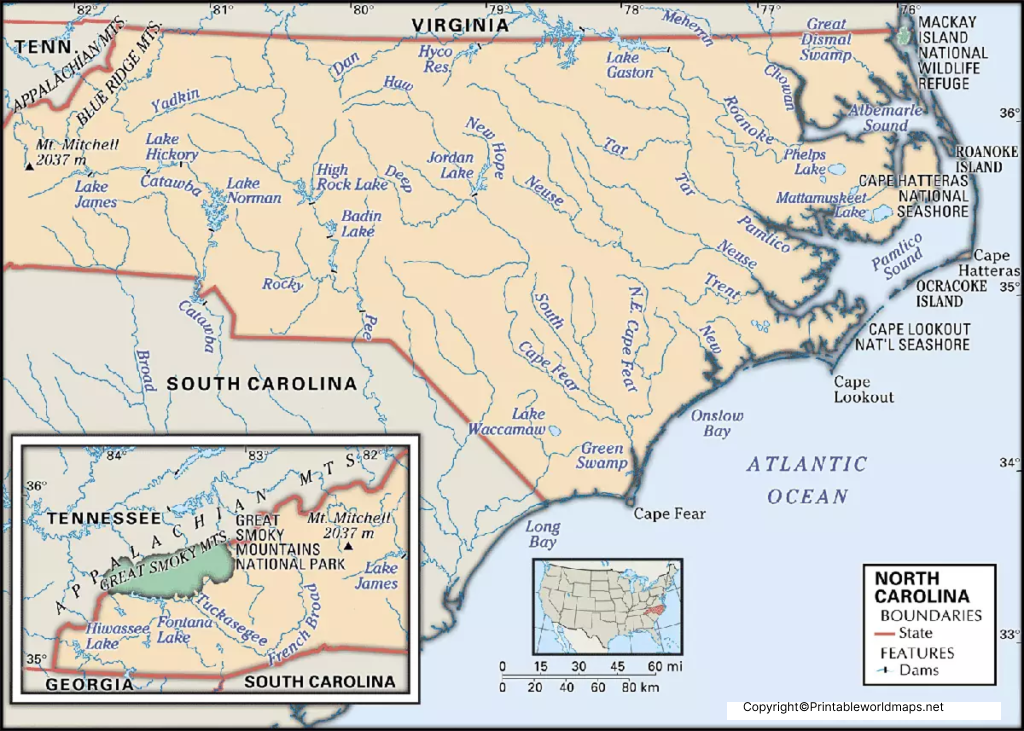
North Carolina shares land borders with Virginia to the north, South Carolina to the south, Tennessee to the west, and Georgia near its southwestern corner. The Atlantic Ocean lies along its eastern coast.
According to the U.S. Census Bureau, North Carolina had an estimated population of 11,197,968 on July 1, 2025. Its land area is approximately 48,623 square miles, based on 2020 Census geographic data.

The state’s geography includes the Blue Ridge and Appalachian Mountains, the Piedmont plateau, coastal plains, rivers, forests, and barrier islands. These features make a labeled map useful for learning about regional geography and planning trips.
Printable Map of North Carolina Labeled

A printable map of North Carolina can help students practice identifying state boundaries, cities, counties, and geographic regions. It is also useful for preparing school projects, geography worksheets, and travel plans.
Choose a PDF when you want to print the map without relying on a screenshot. Before printing, check the page orientation and print preview so the state’s outline and labels remain readable.
North Carolina has 100 counties, each with its own county government. Examples include Wake, Mecklenburg, Guilford, Buncombe, Cumberland, Durham, and New Hanover counties. For an official list and county information, visit the North Carolina government website.
Labeled Map of North Carolina with Cities

A labeled map of North Carolina with cities makes it easier to compare the locations of the state’s major urban centers and understand how they are distributed across different regions.
Some well-known cities include:
- Charlotte: The state’s largest city by population and a major financial and business center.
- Raleigh: The state capital and part of the Research Triangle region.
- Greensboro: A major city in the Piedmont Triad.
- Durham: Known for its universities, research, and healthcare institutions.
- Winston-Salem: A city with a strong history in manufacturing and the arts.
- Fayetteville: Home to Fort Liberty and a significant military community.
- Wilmington: A coastal city with a historic downtown and port.
- Asheville: A mountain city known for its arts, architecture, and access to outdoor recreation.
- Cary: A large municipality in the Raleigh metropolitan area.
- High Point: Known for its furniture industry and related trade events.
City population rankings depend on the year and whether the comparison uses city boundaries or metropolitan areas. For current population estimates, consult the U.S. Census Bureau.
Labeled North Carolina Map with Capital
Raleigh is the capital of North Carolina and is located in Wake County. It is an important center for state government, education, technology, and research. Raleigh is also part of the Research Triangle, a region associated with Raleigh, Durham, and Chapel Hill.
The North Carolina State Capitol, which opened in 1840, is a historic landmark in downtown Raleigh. The city is often called the City of Oaks, reflecting its association with oak trees.
One important map detail is that Raleigh is in Wake County, not Mecklenburg County. Mecklenburg County contains Charlotte, the state’s largest city by population.
North Carolina’s Geographic Regions
North Carolina can be understood through three broad geographic regions. A physical or regional map helps distinguish their locations and landscapes.
1. Mountain Region
The western part of the state contains the Appalachian Mountains, including the Blue Ridge Mountains. Asheville, Boone, and surrounding mountain communities are useful reference points when studying this region.
2. Piedmont Region
The Piedmont lies between the mountains and the coastal plain. It includes major urban centers such as Charlotte, Greensboro, Winston-Salem, Raleigh, and Durham.
3. Coastal Plain
The eastern part of the state contains low-lying coastal landscapes, estuaries, rivers, beaches, and barrier islands. Wilmington and the Outer Banks are prominent geographic reference points.
These regions help explain differences in terrain, settlement patterns, transportation, and outdoor recreation across North Carolina.
Important Rivers and Water Features in North Carolina
A physical map of North Carolina can help identify rivers and coastal water features. Important rivers include the Roanoke, Tar, Neuse, Cape Fear, and Catawba rivers.
The state also has extensive sounds, estuaries, and coastal wetlands. The Outer Banks, a chain of barrier islands, form a distinctive part of its Atlantic coastline.
Use a physical map alongside a labeled political map when you need to compare landforms and waterways with state, county, or city boundaries.
North Carolina Map Facts
| Feature | Information |
|---|---|
| State capital | Raleigh |
| Largest city by population | Charlotte |
| State nickname | Tar Heel State |
| Number of counties | 100 |
| Land area | Approximately 48,623 square miles |
| Estimated population | 11,197,968 (July 1, 2025 estimate) |
| Bordering states | Virginia, South Carolina, Tennessee, and Georgia |
| Eastern coastline | Atlantic Ocean |
| Broad geographic regions | Mountains, Piedmont, and Coastal Plain |
Data note: Population estimates change over time. The population figure above is the U.S. Census Bureau’s July 1, 2025 estimate; land area is based on 2020 Census geographic data. Use the linked official sources for updates.
How to Use a Labeled Map of North Carolina
A labeled North Carolina map can be used for school assignments, travel planning, and general geographic research.
- Locate Raleigh to identify the state capital.
- Find Charlotte, Greensboro, Durham, and other major cities.
- Identify the state’s four neighboring states and its Atlantic coastline.
- Compare the mountain, Piedmont, and coastal regions.
- Use a county map when you need to locate a specific county or county seat.
- Download a printable PDF for offline reference or classroom activities.
Different maps serve different purposes. A city map is best for finding urban centers, a county map is better for administrative boundaries, and a physical map is useful for understanding terrain and waterways.
Frequently Asked Questions
What is the capital of North Carolina?
Raleigh is the capital of North Carolina. It is located in Wake County and serves as the state’s center of government.
What is the largest city in North Carolina?
Charlotte is North Carolina’s largest city by population. Population rankings can differ when comparing city limits with metropolitan areas.
How many counties are in North Carolina?
North Carolina has 100 counties. Official county information is available through the North Carolina government website.
Where can I download a printable map of North Carolina?
You can download the printable map linked in this article as a PDF. Select the version that best suits your needs, such as a general labeled map, a cities map, or a map showing the state capital.
Which states border North Carolina?
North Carolina shares land borders with Virginia, South Carolina, Tennessee, and Georgia. The Atlantic Ocean lies along its eastern coastline.
What are the three main geographic regions of North Carolina?
The three broad regions are the Mountain Region, Piedmont, and Coastal Plain. They differ in elevation, landscape, and settlement patterns.
Is Raleigh in Mecklenburg County?
No. Raleigh is in Wake County. Mecklenburg County is home to Charlotte.
What is North Carolina’s nickname?
North Carolina is known as the Tar Heel State. The nickname is widely associated with the state’s history and traditions.
What is the population of North Carolina?
The U.S. Census Bureau estimated North Carolina’s population at 11,197,968 on July 1, 2025. Check the Census Bureau for the latest estimates.
Reference links
https://www.census.gov/quickfacts/NC
https://data.census.gov/profile/North_Carolina?g=0400000US37
https://www.nc.gov/your-government/county-government-websites
https://www.ncleg.gov/EnactedLegislation/Statutes/HTML/BySection/Chapter_153A/GS_153A-10.html
https://historicsites.nc.gov/all-sites/north-carolina-state-capitol
