

A labeled map of Sudan is a useful resource for students, teachers, geography enthusiasts, and anyone who wants to learn about the country’s states, major cities, and capital. Located in northeastern Africa, Sudan has diverse landscapes, including desert regions, river valleys, plains, and Red Sea coastline.
Khartoum is Sudan’s capital. The country is commonly divided into 18 administrative states, making a labeled map especially helpful for understanding its regional geography. You can use the maps below for educational activities, geography assignments, presentations, and general reference.
Labeled Map of Sudan
A labeled map of Sudan helps you identify the country’s location, major geographical features, and important places. It provides a visual overview that makes studying Sudan’s geography easier than relying on place names alone.

Use the map to locate Sudan within Africa, identify important cities, and understand the country’s general shape and position relative to neighboring countries. For schoolwork, check that the map’s labels are readable at your preferred print size.
Labeled Map of Sudan with States
Sudan’s administrative divisions are useful for understanding the country’s regional geography. Reference sources commonly list 18 states, including Khartoum, Gezira, Northern, Red Sea, North Darfur, and Blue Nile.

A state map helps learners compare the locations of administrative areas and understand how Sudan is organized geographically. Use it to practise identifying state names, locating neighboring states, and matching each state with its administrative capital.
Administrative arrangements and place-name spellings can vary between map editions. For formal research, compare older printable maps with a recent administrative reference.
Sudan Map with Cities Labeled
A Sudan map with cities labeled helps readers identify important urban centers and understand their positions in relation to rivers, states, roads, and neighboring countries.

Some well-known Sudanese cities include Khartoum, Omdurman, Port Sudan, Wad Madani, Kassala, and El Obeid. Their locations help illustrate the relationship between settlement patterns, transport routes, administrative centers, and the country’s physical geography.
City labels and boundaries may differ according to the map’s publication date and level of detail. Always check the map legend and date when using it for academic work.
Labeled Sudan Map with Capital
Khartoum is the capital of Sudan and is located near the meeting point of the Blue Nile and White Nile rivers. The surrounding urban area includes Omdurman and Khartoum North, also known as Bahri.
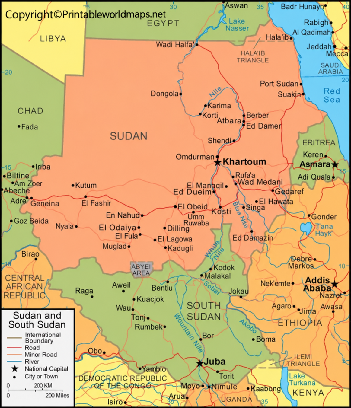
A capital-labeled map helps distinguish the national capital from state administrative capitals and other major cities. Sudan’s states have their own administrative centers, but these should not be confused with the country’s national capital.
Because conflict and changing administrative conditions can affect access to cities and government operations, this map is intended for geographical and educational reference rather than current travel or security planning.
Sudan’s 18 States: Names to Know
The following names are commonly listed as Sudan’s 18 administrative states:
- Blue Nile
- Central Darfur
- East Darfur
- Gedaref
- Gezira (Al Jazirah)
- Kassala
- Khartoum
- North Darfur
- North Kordofan
- Northern
- Red Sea
- River Nile
- Sennar
- South Darfur
- South Kordofan
- West Darfur
- West Kordofan
- White Nile
Use this list alongside the state map to practise locating each administrative area. Alternative English spellings, such as Gezira and Al Jazirah, may appear in different references.
Important Geography Facts About Sudan
These facts provide additional context when studying a labeled map of Sudan.
- Continent: Africa, in the northeastern part of the continent.
- National capital: Khartoum.
- Administrative divisions: Commonly listed as 18 states.
- Coastline: Sudan borders the Red Sea to the east.
- Neighboring countries: Egypt, Libya, Chad, the Central African Republic, South Sudan, Ethiopia, and Eritrea.
- Major river system: The Nile, including the Blue Nile and White Nile.
- Major mountain area: The Marrah Mountains in western Sudan.
- Landscape: Northern desert, central plains, river valleys, western highlands, and eastern Red Sea hills.
These geographical features explain why physical maps, political maps, and city maps each provide different kinds of information.
Why Use a Printable Map of Sudan?
Printable maps are convenient for learning, teaching, and reference. A labeled map can help users:
- Memorize state and city names.
- Locate Sudan’s capital and major urban centers.
- Understand the country’s borders and neighboring countries.
- Prepare geography assignments, classroom worksheets, and presentations.
- Compare political boundaries with rivers and other physical features.
- Practise map-reading skills without relying entirely on digital devices.
For best results, choose a high-resolution image or PDF. Check the map’s labels before printing, especially if you need to read smaller state or city names.
How to Use the Sudan Map for Learning
Start by locating Sudan in northeastern Africa. Next, identify Khartoum and the Nile river system. Then use the state map to find individual administrative divisions and the city map to practise locating major urban centers.
For a simple study exercise, cover the labels on a printed copy and try to name the states from memory. Check your answers against the labeled version. Teachers can also use the map for quizzes, classroom discussions, and geography projects.
If you need the map for a formal report, verify boundary information and spellings against a recognized geographical or humanitarian mapping source.
Frequently Asked Questions About the Labeled Map of Sudan
1. What is the capital of Sudan?
Khartoum is the capital of Sudan. It is located near the confluence of the Blue Nile and White Nile rivers.
2. How many states does Sudan have?
Sudan is commonly listed as having 18 administrative states. For current administrative or operational information, consult an up-to-date reference.
3. Can I download a labeled map of Sudan as a PDF?
Yes. PDF versions are linked in the sections above. Open the relevant PDF link to view or download the map, subject to the source website’s availability.
4. What is the difference between a state map and a city map?
A state map emphasizes administrative boundaries and state names. A city map focuses on urban locations and place names. Some maps combine both types of information.
5. Which major cities should I locate on a Sudan map?
Khartoum, Omdurman, Port Sudan, Wad Madani, Kassala, and El Obeid are useful starting points for geography study.
6. Which countries border Sudan?
Sudan shares land borders with Egypt, Libya, Chad, the Central African Republic, South Sudan, Ethiopia, and Eritrea. It also has a coastline along the Red Sea.
7. Why is the Nile important to Sudan’s geography?
The Nile river system is a major physical feature of Sudan. The Blue Nile and White Nile meet in the Khartoum area, and the river system is important for understanding settlement patterns and regional geography.
8. Are these maps suitable for school projects?
They can be useful for school projects, classroom activities, and general geography learning. Check the map’s source, publication date, labels, and permitted use before including it in a published or formally assessed project.
Reference links
https://www.cia.gov/the-world-factbook/countries/sudan
https://www.britannica.com/place/Sudan
https://www.euaa.europa.eu/coi/sudan/2025/country-focus/sudan-country-focus/maps
https://tran.sudanembassy-kw.com/state.html
https://whc.unesco.org/en/statesparties/sd
https://data.worldbank.org/country/sudan
https://printableworldmaps.net/wp-content/uploads/2023/07/Labeled-Map-of-Sudan.png
https://printableworldmaps.net/wp-content/uploads/2025/05/Labeled-Map-of-Sudan.pdf
https://worldmapblank.com/wp-content/uploads/2021/04/Labeled-Sudan-Map-with-States.jpg
https://printableworldmaps.net/wp-content/uploads/2023/07/Labeled-Sudan-Map-with-States.pdf
https://printableworldmaps.net/wp-content/uploads/2023/07/Sudan-Map-with-Cities-Labeled.png
https://printableworldmaps.net/wp-content/uploads/2025/05/Sudan-Map-with-Cities-Labeled.pdf
https://printableworldmaps.net/wp-content/uploads/2023/07/image-380.png
https://printableworldmaps.net/wp-content/uploads/2023/07/Labeled-Sudan-Map-with-Capital.pdf


