


The Danube River on World Map helps you locate one of Europe’s most important rivers and understand its route through Central and Southeastern Europe. The Danube flows from Germany toward the Black Sea, passing through or forming the borders of ten European countries.
On this page, you can explore a Danube River map with cities, view its location on a world map, and access printable map images and PDF versions for educational use. These maps are useful for students, teachers, geography projects, and anyone interested in European rivers.
Danube River Map with Cities
Use the Danube River map with cities to identify the river’s route and some of the major urban centres along its banks.

The Danube is approximately 2,850 kilometres (1,770 miles) long, making it the second-longest river in Europe after the Volga. It begins in Germany’s Black Forest region and flows generally eastward toward the Black Sea.
Several well-known cities are located along the river, including Vienna in Austria, Bratislava in Slovakia, Budapest in Hungary, and Belgrade in Serbia. These cities have long benefited from the Danube’s importance in transport, trade, settlement, and tourism.
The river passes through or forms the borders of ten countries: Germany, Austria, Slovakia, Hungary, Croatia, Serbia, Romania, Bulgaria, Moldova, and Ukraine.

A city map is particularly useful for understanding how the Danube connects different European countries and capital cities. Check the labels on the map to identify individual locations and follow the river’s course.
Danube River on World Map
The Danube River on World Map shows the river’s position within Europe and its connection to the Black Sea.

The Danube is located in Central and Southeastern Europe. It starts in southwestern Germany, travels through or along several national territories, and reaches the Black Sea through the Danube Delta, primarily in Romania, with part of the delta extending into Ukraine.
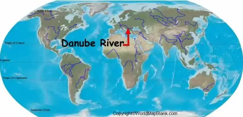
A world map provides a broad geographical view, while a regional map gives more detail about the river’s route, nearby countries, cities, and tributaries.
When studying the Danube on a world map, look for Germany in Central Europe and trace the river eastward. Follow its route past Austria, Slovakia, Hungary, Serbia, and Romania toward the Black Sea.
These maps can help learners identify the river’s general location, trace its direction of flow, and understand its importance to the geography of Europe.
Printable Danube River on World Map
A printable Danube River on World Map is useful for classroom assignments, geography revision, school projects, and personal study.

You can use a printable map to mark the river’s source, major cities, countries, and mouth. A PDF is convenient for printing or viewing on a computer, tablet, or smartphone.
For the best results, choose a map with clear labels and sufficient resolution. If you plan to use it in a school assignment or publication, check the image’s licence and attribution requirements before reproducing it.
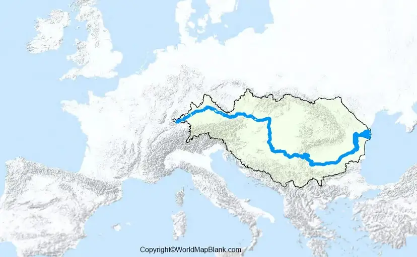
You can also compare the world map with a regional map to understand the Danube’s route in greater detail.
Where Is the Danube River Located?
The Danube River is in Europe. Its source region lies in Germany’s Black Forest, and its water flows eastward through Central and Southeastern Europe before reaching the Black Sea.
The river’s location makes it an important geographical link between inland Europe and the Black Sea region. Its course crosses varied landscapes, including valleys, plains, gorges, and wetlands.
The Danube Delta is an extensive wetland environment formed where the river divides into distributaries before entering the Black Sea. It is known for its ecological importance and diverse wildlife.
Which Countries Does the Danube River Flow Through?
The main course of the Danube passes through or forms a border along ten countries:
- Germany
- Austria
- Slovakia
- Hungary
- Croatia
- Serbia
- Romania
- Bulgaria
- Moldova
- Ukraine
The exact relationship between the river and each country varies: in some places, it flows within the country, while elsewhere it marks an international boundary.
Important geographical distinction: The Danube River itself is associated with ten countries, whereas the wider Danube River Basin, including tributaries and surrounding drainage areas, extends across 19 countries. These figures describe different geographical areas.
What Is the Source and Mouth of the Danube River?
The Danube’s source region is in Germany’s Black Forest. The river is formed by the meeting of the Brigach and Breg streams at Donaueschingen.
Its mouth is the Danube Delta, where the river enters the Black Sea. The delta is an important wetland region shared by Romania and Ukraine.
Knowing the source and mouth makes it easier to trace the river accurately on a map and understand the direction in which its water flows.
7 Amazing Facts About the Danube River
- Second-longest river in Europe: The Danube is approximately 2,850 kilometres long, after the Volga.
- Ten countries along its main course: The river flows through or forms borders between ten European countries.
- Four capital cities on the river: Vienna, Bratislava, Budapest, and Belgrade are directly located on the Danube.
- Flows into the Black Sea: The river reaches the sea through the Danube Delta.
- A major international river basin: The wider drainage basin extends across 19 countries.
- Important for transport and trade: The Danube supports inland navigation and economic connections across Europe.
- Rich natural habitats: The Danube Delta and other river environments support diverse fish, birds, and wetland ecosystems.
Why Is the Danube River Important?
The Danube has geographical, economic, cultural, and environmental importance. It connects cities and communities across national borders and supports inland shipping, tourism, fishing, and other economic activities.
The wider river basin also provides freshwater and supports agriculture, ecosystems, and human settlements. However, pollution, habitat loss, and other environmental pressures make river protection and international cooperation important.
The International Commission for the Protection of the Danube River (ICPDR) coordinates cooperation among participating countries to improve water quality and protect the river basin.
How to Use a Danube River Map for Study
Follow these steps to get the most value from a Danube River map:
- Locate Europe on a world map.
- Find Germany and identify the Danube’s source region.
- Trace the river toward Austria, Slovakia, Hungary, and Southeastern Europe.
- Mark Vienna, Bratislava, Budapest, and Belgrade.
- Follow the lower river toward Romania, Bulgaria, Moldova, and Ukraine.
- Locate the Danube Delta and the Black Sea.
- Compare the river map with a political map of Europe to understand country boundaries.
This exercise helps improve map-reading skills and builds an understanding of European physical and political geography.
Frequently Asked Questions About the Danube River
Where is the Danube River on the world map?
The Danube River is in Europe. It begins in Germany’s Black Forest region and flows eastward through Central and Southeastern Europe to the Black Sea.
How many countries does the Danube River flow through?
The Danube’s main course passes through or forms borders along ten countries. Its wider river basin extends across 19 countries.
What is the length of the Danube River?
The Danube is approximately 2,850 kilometres (1,770 miles) long. Published figures can vary slightly depending on the measurement method and the definition of its source.
Where does the Danube River start and end?
The river originates in Germany’s Black Forest region, where the Brigach and Breg streams meet at Donaueschingen. It ends in the Black Sea through the Danube Delta.
Which capital cities are located on the Danube River?
Vienna, Bratislava, Budapest, and Belgrade are the four national capital cities directly located on the Danube.
Can I download a printable Danube River map?
Yes. You can use the map and PDF links provided above to view or print the available Danube River maps. Check the individual file and its usage permissions before reproducing it.
Why is the Danube River important to Europe?
The Danube supports inland navigation, trade, tourism, freshwater resources, cultural connections, and important natural habitats across several European countries.
Is the Danube the longest river in Europe?
No. The Danube is the second-longest river in Europe, after the Volga.
Reference links
https://www.icpdr.org/danube-basin/danube-river-basin/danube-river-basin-overview-map
https://www.icpdr.org/danube-basin/countries
https://www.cia.gov/the-world-factbook/about/archives/2023/field/major-rivers-by-length-in-km
