
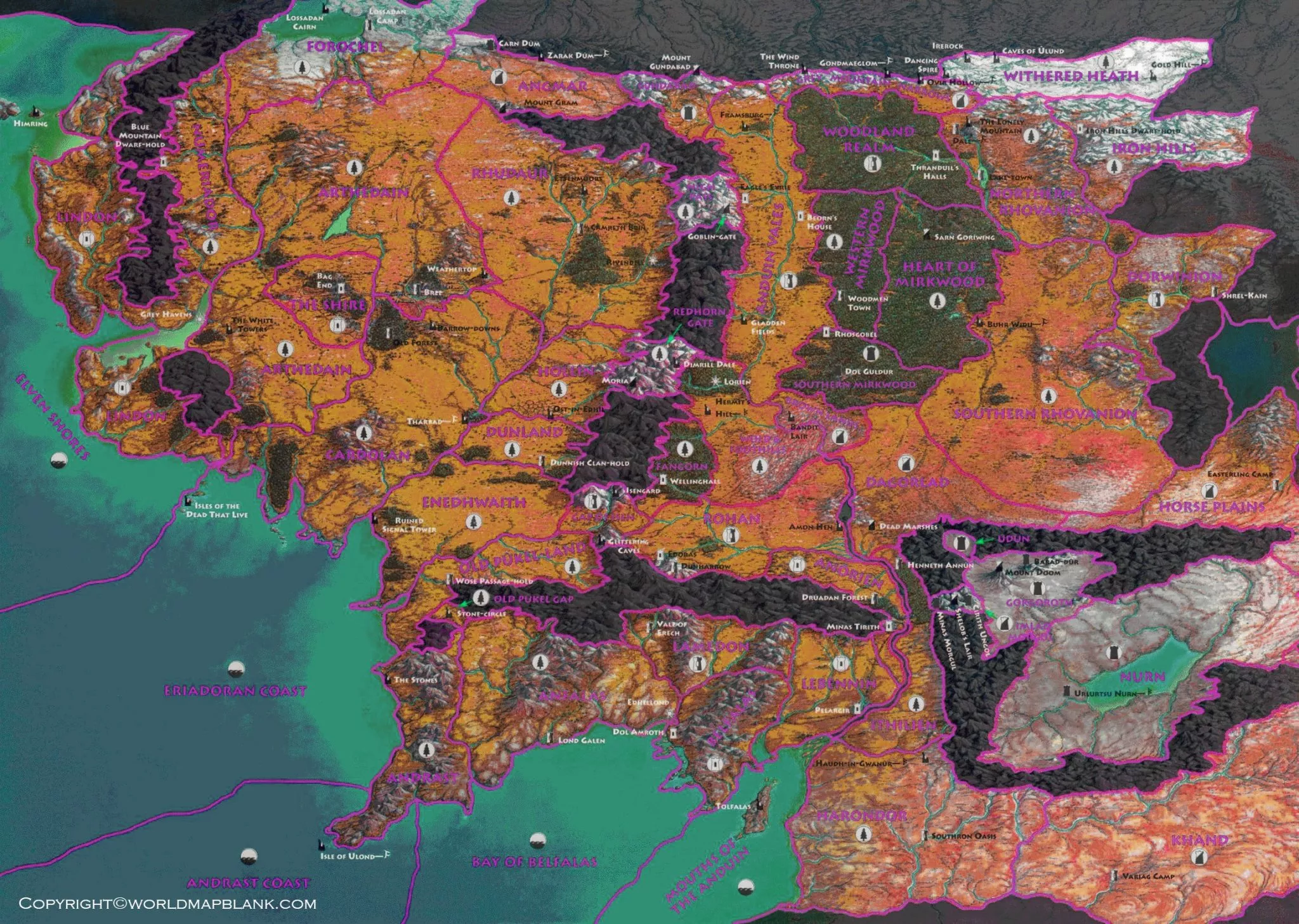

The Middle Earth Map is a detailed representation of the fictional lands created by J.R.R. Tolkien for his Middle-earth stories. Middle-earth is an imagined setting within Tolkien’s larger legendarium and is most closely associated with The Hobbit, The Lord of the Rings, and The Silmarillion.
Tolkien treated maps as an important part of his creative process. The Tolkien Estate notes that he created more than thirty maps while developing his stories, using them to understand geography, locations, journeys, and events within his fictional world.
This Middle Earth Map collection provides different views of Tolkien’s fictional geography, including detailed maps, labeled maps, high-resolution versions, and printable PDF resources.
Middle Earth Map
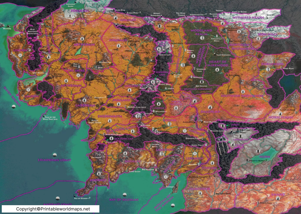
A Middle Earth Map can help readers understand the locations and geographical relationships that appear throughout Tolkien’s stories. Important areas commonly shown on maps of Middle-earth include Eriador, Rohan, Gondor, Mordor, the Misty Mountains, the Shire, Rivendell, and many other locations.
Tolkien’s maps were not simply decorative illustrations. Mapping was part of how he developed and visualized the setting of his stories. The Tolkien Estate describes his maps as an integral part of his world-building process.
Middle Earth Map
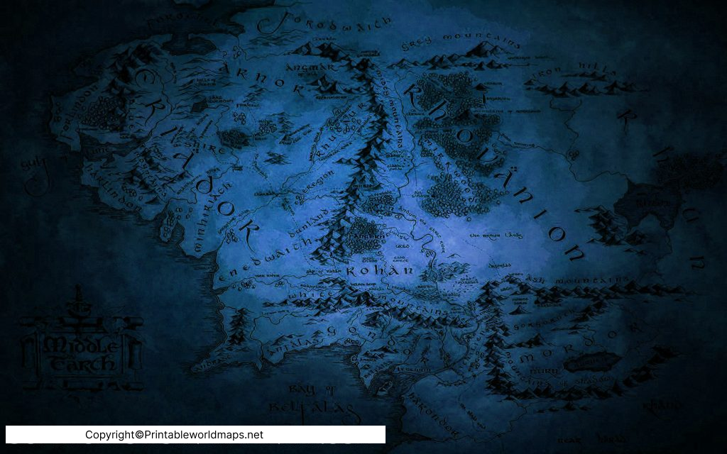
Different maps of Middle-earth can represent different periods, regions, and levels of detail. This is important because Tolkien’s fictional world changed substantially over its long history.
For example, Beleriand belongs primarily to the First Age and was later destroyed during the War of Wrath. Later maps associated with The Lord of the Rings primarily show the western regions of Middle-earth during the Third Age.
Therefore, a map should always be considered in relation to the period and source it represents rather than treated as one permanent map of Middle-earth.
World Map of Middle Earth [Detailed Map of Middle Earth]
![World Map of Middle Earth [Detailed Map of Middle Earth]](https://worldmapblank.com/wp-content/uploads/2021/12/middle-earth-world-map-1024x723.jpg?ezimgfmt=rs:828x585/rscb2/ng:webp/ngcb2 "Middle Earth Map | Middle Earth Full World Map in Detailed 5")
The World Map of Middle Earth is useful for understanding the broad geographical layout of Tolkien’s fictional setting. Depending on the map, readers may be able to identify major mountain ranges, rivers, forests, settlements, kingdoms, and other locations connected with the stories.
One important distinction is that Middle-earth is not the entire world of Tolkien’s legendarium. Tolkien’s wider fictional world is called Arda, while Middle-earth is one of its major regions. This distinction helps avoid confusion when comparing maps from different books and historical periods.
The maps associated with The Lord of the Rings focus particularly on the western parts of Middle-earth relevant to the story. Christopher Tolkien later produced revised maps incorporating additional information from Tolkien’s writings.
Middle Earth Map High Resolution
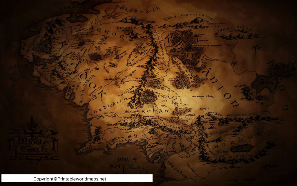
A high-resolution Middle Earth Map is useful when you want to examine smaller geographical details. Depending on the map, you may be able to identify places such as the Shire, Bree, Rivendell, Moria, Lothlórien, Rohan, Gondor, Mordor, and other locations associated with Tolkien’s stories.
The Misty Mountains are particularly important geographically because they form a major mountain range through the western portion of Middle-earth. Tolkien also created artwork and maps of locations such as the Misty Mountains as part of his creative process.
Full Map of Middle Earth
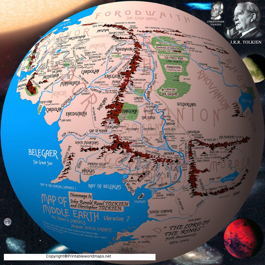
A Full Map of Middle Earth can provide a broader view of the regions connected with Tolkien’s stories. Labeled versions are especially useful for readers who want to identify places while reading The Hobbit or The Lord of the Rings.
However, there is no single map that perfectly represents every period of Tolkien’s fictional history. First Age maps can look substantially different from Third Age maps because the geography itself changes over Tolkien’s chronology. Beleriand, for example, was a major First Age region that was destroyed at the end of that age.
Middle Earth Full World Map
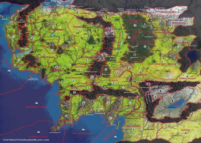
A Middle Earth Full World Map is useful for readers who want to explore Tolkien’s fictional geography beyond individual locations. Maps can make long journeys and relationships between regions easier to understand while reading the books.
For example, the journey in The Lord of the Rings crosses several important geographical areas, making locations such as the Shire, Rivendell, the Misty Mountains, Rohan, Gondor, and Mordor significant points of reference.
Christopher Tolkien’s later map, The West of Middle-earth at the End of the Third Age, represents the western regions during the period surrounding the War of the Ring and incorporates additional information from Tolkien’s writings.
Important Places on the Middle Earth Map
A detailed Middle Earth Map becomes easier to understand when its major locations are grouped geographically.
- The Shire – Home of the Hobbits and the starting point of Frodo and Sam’s journey.
- Bree – An important settlement in Eriador and a meeting point on the road east.
- Rivendell – The refuge of Elrond and an important location in The Lord of the Rings.
- Misty Mountains – A major mountain range crossed during the journey.
- Moria – The ancient underground realm of the Dwarves beneath the Misty Mountains.
- Lothlórien – The woodland realm associated with Galadriel and Celeborn.
- Rohan – A kingdom of the Rohirrim.
- Gondor – One of the major kingdoms of Men during the Third Age.
- Mordor – The land dominated by Sauron and the location of Mount Doom.
- Isengard – The fortified location associated with Saruman.
- Fangorn Forest – An ancient forest important to the events of The Lord of the Rings.
Middle Earth Map and Tolkien’s World-Building
Maps were unusually important to Tolkien’s writing process. The Tolkien Estate explains that Tolkien drew maps while developing his stories and used them to visualize scenes, places, distances, and journeys.
The surviving maps also demonstrate that Tolkien’s geography developed over time. The General Map of Middle-earth was created by Christopher Tolkien from sketches and material associated with J.R.R. Tolkien, while later maps incorporated additional information from Tolkien’s other writings.
This makes the Middle Earth Map more than a simple fictional location chart. It is also useful for understanding how Tolkien connected geography, history, languages, cultures, and storytelling.
First Age, Second Age and Third Age Maps
One of the most useful ways to understand Tolkien’s maps is through his fictional chronology.
First Age
The First Age includes regions such as Beleriand. Beleriand occupied the northwestern part of Middle-earth and was the setting for major events described in The Silmarillion. It was destroyed at the end of the First Age. Tolkien Gateway
Second Age
The Second Age includes major events involving Númenor, Sauron, the Rings of Power, and the Last Alliance of Elves and Men. Maps from this period can therefore differ significantly from familiar maps of the War of the Ring.
Third Age
The Third Age is the period most closely associated with The Hobbit and The Lord of the Rings. Maps from this period show locations such as the Shire, Rohan, Gondor, Mordor, and other regions central to the stories.
Middle Earth Map for Students and Readers
A printable Middle Earth Map can be useful for:
- Following character journeys while reading Tolkien’s books
- Identifying fictional regions and settlements
- Understanding distances and geographical relationships
- Creating classroom or literature-study materials
- Using as a visual reading companion
- Comparing First Age and Third Age geography
- Studying Tolkien’s approach to fictional world-building
For educational use, it is helpful to identify the source and time period of a map rather than assuming that every Middle-earth map represents exactly the same geography.
Why Middle Earth Maps Are Different
There are multiple versions and interpretations of Middle-earth maps. Tolkien himself produced maps and sketches, while Christopher Tolkien later edited and developed maps based on his father’s materials. Other cartographers have also created interpretive maps and atlases.
Karen Wynn Fonstad’s The Atlas of Middle-earth, for example, presents maps of locations and events from The Hobbit, The Lord of the Rings, and The Silmarillion. It treats Tolkien’s geography using techniques associated with conventional atlases, while also attempting to reconcile information from different writings.
This is why readers may encounter differences in scale, place names, boundaries, and geographical interpretations between different Middle-earth maps.
Frequently Asked Questions About the Middle Earth Map
Is Middle-earth a real place?
No. Middle-earth is a fictional setting created by J.R.R. Tolkien. It is part of his larger imagined world and is associated particularly with The Hobbit and The Lord of the Rings.
Is Middle-earth the entire world?
No. Middle-earth is a major region within Tolkien’s fictional world of Arda. Maps of Arda can include regions beyond Middle-earth.
Who created the original Middle-earth maps?
J.R.R. Tolkien created numerous maps and sketches during the development of his stories. Christopher Tolkien later created and edited important published maps using his father’s materials.
What are the main locations on a Middle Earth Map?
Commonly identified locations include the Shire, Bree, Rivendell, the Misty Mountains, Moria, Lothlórien, Rohan, Gondor, Mordor, Isengard, and Fangorn Forest.
Why are there different Middle Earth Maps?
Tolkien’s fictional geography changed across different periods of his legendarium, and different maps focus on different regions or periods. Later editors and cartographers also created maps using Tolkien’s writings and surviving map material.
What is Beleriand?
Beleriand was a major region of northwestern Middle-earth during the First Age. It was destroyed during the War of Wrath at the end of the First Age.
What is the best map to use while reading The Lord of the Rings?
A detailed Third Age map focused on the western regions of Middle-earth is generally the most relevant type for following the main journey in The Lord of the Rings. Christopher Tolkien’s later map specifically depicts the Westlands during the War of the Ring.
Can I print a Middle Earth Map?
You can use the printable image and PDF resources provided on this page according to the applicable copyright and usage rights. Tolkien-related maps and artwork may be copyrighted, so check the rights associated with a particular map before redistributing or commercially using it.
Reference Links
https://tolkiengateway.net/wiki/General_Map_of_Middle-earth
https://tolkiengateway.net/wiki/The_West_of_Middle-earth_at_the_End_of_the_Third_Age
