

A labeled map of Kansas helps you identify the state’s location, capital city, major cities, neighboring states, rivers, and county boundaries. Located in the Midwestern United States, Kansas is known for its Great Plains landscapes, agricultural heritage, and extensive road network.
Kansas borders Nebraska to the north, Missouri to the east, Oklahoma to the south, and Colorado to the west. It became the 34th U.S. state on January 29, 1861. Its capital is Topeka, while Wichita is its largest city.
Whether you are a student, teacher, traveler, or geography enthusiast, these Kansas maps can help you understand the state’s geography and locate important places.
Labeled Map of Kansas
A labeled map of Kansas provides a convenient overview of the state’s boundaries and geographical features. Depending on the map’s level of detail, it may show cities, highways, rivers, lakes, and neighboring states.
Kansas covers approximately 81,759 square miles of land, making it the 13th-largest U.S. state by land area. Its landscape includes broad plains, rolling hills, river valleys, and the distinctive Flint Hills region.
Use this map to identify Kansas’s position within the Midwest and understand how its major transportation routes connect different parts of the state.
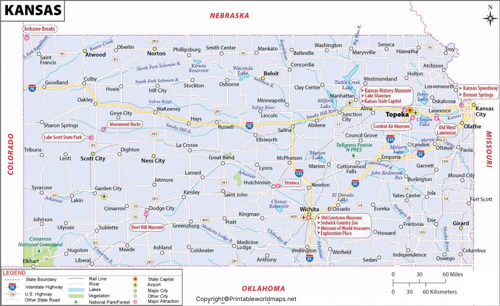
Labeled Map of Kansas Printable
A printable Kansas map is useful for classroom activities, geography assignments, presentations, and personal reference. A PDF version is particularly convenient when you need a document that can be printed or saved for offline use.
Before printing, check whether the map includes the labels you need. A general state map may show major cities and boundaries, while a county map is more suitable for studying local administrative divisions.
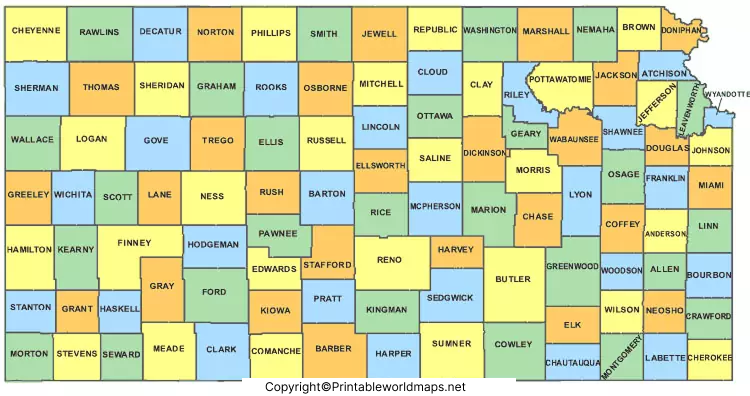
Kansas has 105 counties. A county map can help students understand how the state is divided into smaller geographic and administrative areas.

For a more detailed geography exercise, label the neighboring states, the capital city, major rivers, and several prominent cities on a blank Kansas map.
Labeled Map of Kansas with Cities
A labeled map of Kansas with cities helps readers locate major population centers and understand their distribution across the state.
Important Kansas cities include:
- Wichita: The largest city in Kansas and an important center for aviation, manufacturing, and business.
- Overland Park: A major city in the Kansas City metropolitan area.
- Kansas City, Kansas: A city in Wyandotte County, near the Missouri state line.
- Topeka: The state capital and the seat of Kansas state government.
- Lawrence: A university city known for the University of Kansas.
- Manhattan: Home to Kansas State University.
- Olathe: A major city in the Kansas City metropolitan area.
- Salina: A regional center in north-central Kansas.
- Hutchinson: Known for its salt deposits and the Kansas Cosmosphere.
- Garden City: An important regional center in southwestern Kansas.

City populations change over time, so current population comparisons should use the latest U.S. Census Bureau estimates or census results rather than undated figures.
When using a city map, check the labels carefully. Kansas City, Kansas, and Kansas City, Missouri, are separate cities located in different states.
Labeled Kansas Map with Capital
The capital of Kansas is Topeka, located in Shawnee County in the northeastern part of the state. Topeka is an important center for state government, public administration, education, and regional commerce.
A Kansas map with the capital marked makes it easier to distinguish the state capital from its largest city, Wichita. Although Wichita has the largest city population, Topeka serves as the seat of state government.
Notable places in Topeka include the Kansas State Capitol, Washburn University, and the Kansas Museum of History. These landmarks provide additional context for understanding the city’s civic, educational, and historical importance.
If you are preparing a school assignment, mark Topeka on the map and identify the Kansas River and the neighboring state of Missouri to build a clearer picture of the region.
Kansas Rivers and Physical Geography
Kansas has an extensive network of rivers and streams that influence its landscape, agriculture, water resources, and settlement patterns.
Major rivers associated with Kansas include:
- Kansas River: Flows eastward through northeastern Kansas and joins the Missouri River near Kansas City, Kansas.
- Arkansas River: Crosses the state and passes through the Wichita area.
- Republican River: Flows through north-central Kansas.
- Smoky Hill River: Flows eastward through central Kansas and joins the Republican River to form the Kansas River.
- Missouri River: Forms part of Kansas’s northeastern and eastern boundary.
The Flint Hills, High Plains, and river valleys are useful geographic features to look for on a physical map. These features help explain the differences in terrain across Kansas.
For additional geographic context, consult the Kansas Secretary of State’s official geography publication and the Kansas Historical Society’s information about the Kansas River.
Kansas Counties and Neighboring States
Kansas contains 105 counties, each with its own geographic boundaries. A county map is especially useful for locating communities, understanding local administration, and comparing population distributions.
The state’s four neighboring states are:
- Nebraska to the north
- Missouri to the east
- Oklahoma to the south
- Colorado to the west
Kansas’s central location makes it an important part of regional road and freight networks. An outline map is useful for identifying the state boundary, while a detailed road map is more appropriate for trip planning.
Interesting Facts About Kansas
Here are some useful facts to remember when studying a labeled Kansas map:
- State capital: Topeka
- Largest city: Wichita
- Statehood: January 29, 1861
- State number: 34th state admitted to the Union
- Number of counties: 105
- Postal abbreviation: KS
- Largest geographic region: Kansas is part of the Great Plains and the U.S. Midwest.
- State nickname: The Sunflower State
- Highest point: Mount Sunflower, near the Colorado border, at approximately 4,039 feet above sea level.
These facts can help students and geography enthusiasts connect map labels with the state’s history, physical landscape, and administrative divisions.
How to Use a Kansas Map for Learning
A labeled Kansas map can be used for several practical activities:
- Geography practice: Locate Topeka, Wichita, Lawrence, and other major cities.
- State identification: Label Nebraska, Missouri, Oklahoma, and Colorado around Kansas.
- River study: Trace the Kansas, Arkansas, Republican, and Smoky Hill rivers.
- County exercises: Use a county map to learn the names and locations of Kansas’s 105 counties.
- Travel planning: Use a road map to identify routes between cities, then verify directions with a current navigation service.
- Classroom printing: Choose a clear PDF or high-resolution map that remains readable when printed.
For travel, always use a current road or navigation map because older printable maps may not show recent road changes or closures.
Frequently Asked Questions About the Labeled Map of Kansas
What is the capital of Kansas?
Topeka is the capital of Kansas. It is located in Shawnee County in the northeastern part of the state.
What is the largest city in Kansas?
Wichita is the largest city in Kansas by population.
How many counties are in Kansas?
Kansas has 105 counties.
Which states border Kansas?
Kansas borders Nebraska, Missouri, Oklahoma, and Colorado.
When did Kansas become a state?
Kansas became the 34th state of the United States on January 29, 1861.
Where can I download a printable Kansas map?
You can use the printable map and PDF links provided in this article. Check the map’s labels and print quality before using it for a school project or presentation.
What rivers should I look for on a Kansas map?
Important rivers include the Kansas, Arkansas, Republican, Smoky Hill, and Missouri rivers.
What is the difference between Topeka and Wichita?
Topeka is the state capital, while Wichita is the largest city in Kansas. They serve different roles in the state’s government and urban geography.
Reference links
https://www.census.gov/quickfacts/fact/table/KS/PST045225
https://www.census.gov/geographies/reference-files/2010/geo/state-local-geo-guides-2010/kansas.html
https://www.travelks.com/media/kansas-facts
https://www.sos.ks.gov/Pubs/Publications/KTAN.pdf
https://www.kansashistory.gov/kansapedia/kansas-river/18523
